
Advanced Search for Maps
Showing 31-36 of 36
Official, Insert/poster-size map with accompanying report
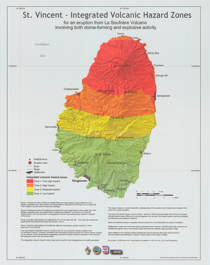
St. Vincent - Integrated volcanic hazard zones for an eruption from La Soufrière Volcano involving both dome-forming and explosive activity
Pocket insert in: Robertson, R. (2005). St. Vincent. In: Lindsay, J.M., Shepherd, J.B., Robertson, R.E.A., & Ali, S. (Eds) Volcanic hazard atlas of the Lesser Antilles. Seismic Research Unit, The University of the West Indies, Trinidad and Tobago, W.I., p. 241-261
Official, Map sheet or poster
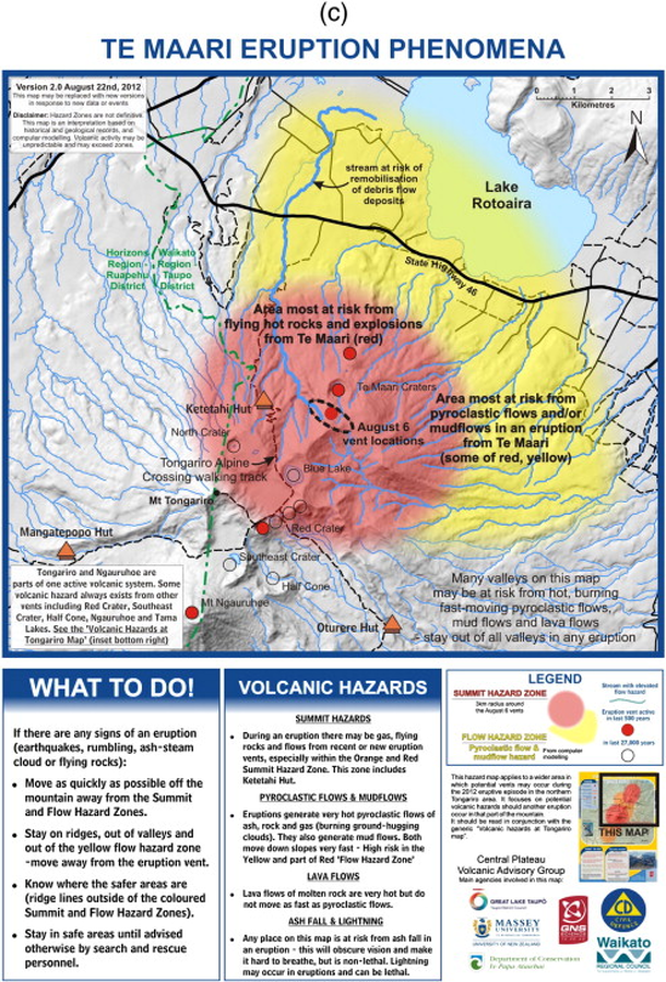
Te Maari Eruption Phenomena
GNS Science (compiler). (2012). Te Maari Eruption Phenomena. Version 2.0, 22 August 2012.
Official, Figure in hazard assessment
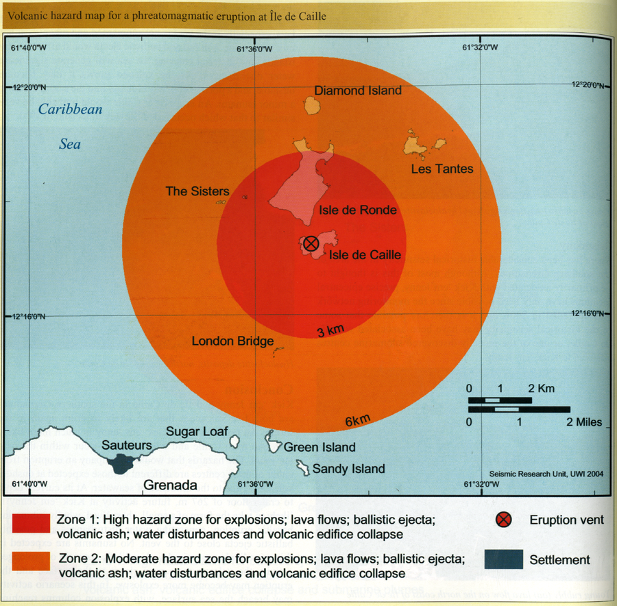
Volcanic hazard map for a phreatomagmatic eruption at Ile de Caille
Page 124 in: Lindsay, J.M. & Shepherd, J.B. (2005). Kick’em Jenny and Ile de Caille. In: Lindsay, J.M., Shepherd, J.B., Robertson, R.E.A., & Ali, S. (Eds) Volcanic hazard atlas of the Lesser Antilles. Seismic Research Unit, The University of the West Indies, Trinidad and Tobago, W.I., p. 105-125.
Official, Figure in hazard assessment
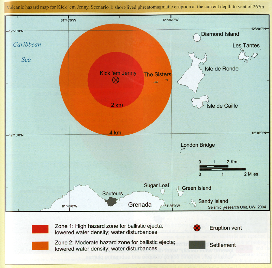
Volcanic hazard map for Kick 'em Jenny, Scenario 1: short-lived phreatomagmatic eruption at the current depth to vent of 267m
Page 121 in: Lindsay, J.M. & Shepherd, J.B. (2005). Kick’em Jenny and Ile de Caille. In: Lindsay, J.M., Shepherd, J.B., Robertson, R.E.A., & Ali, S. (Eds) Volcanic hazard atlas of the Lesser Antilles. Seismic Research Unit, The University of the West Indies, Trinidad and Tobago, W.I., p. 105-125.
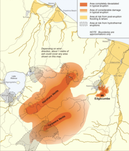
Figure in a journal article
Volcanic hazard map of the Okataina Volcanic Centre
Figure 8 in: Becker, J.S., Saunders, W.S.A., Robertson, C.M., Leonard, G.S., & Johnston, D.M. (2010). A synthesis of challenges and opportunities for reducing volcanic risk through land use planning in New Zealand. The Australasian Journal of Disaster and Trauma Studies, 2010-1. (Simplified from: Nairn, 2002)
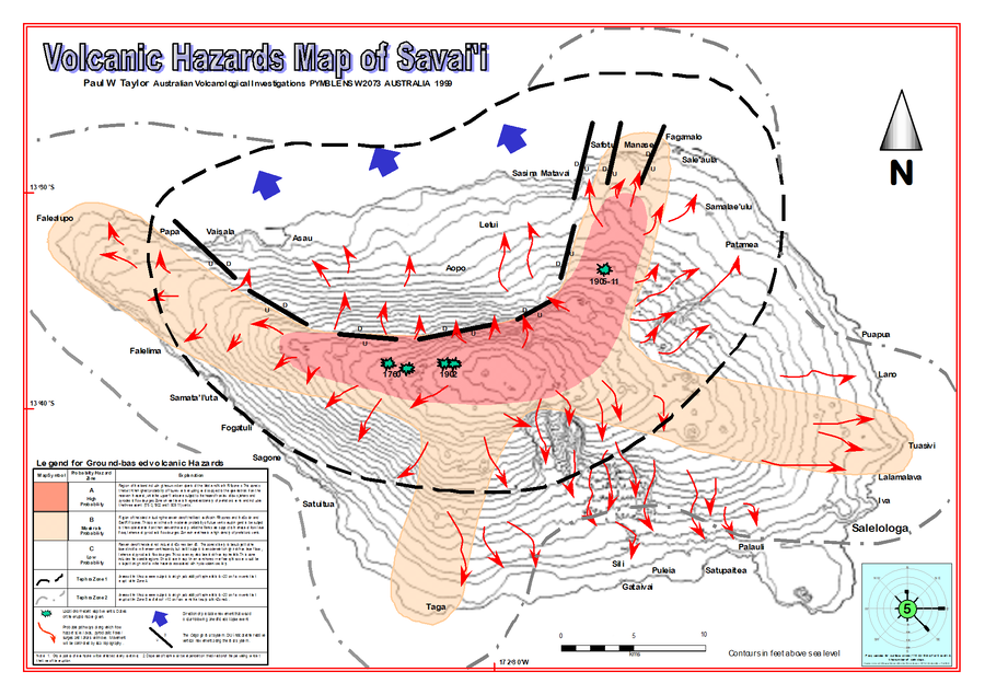
Official, Insert/poster-size map with accompanying report
Volcanic Hazards Map of Savai'i
Insert in: Taylor, P. & Talia, L. (1999). Volcanic Hazards Assessment of Savai'i, Samoa. Pacific Islands Applied Geoscience Commission (SOPAC) Technical Report 295, 25 p.