
Advanced Search for Maps
Showing 21-30 of 36
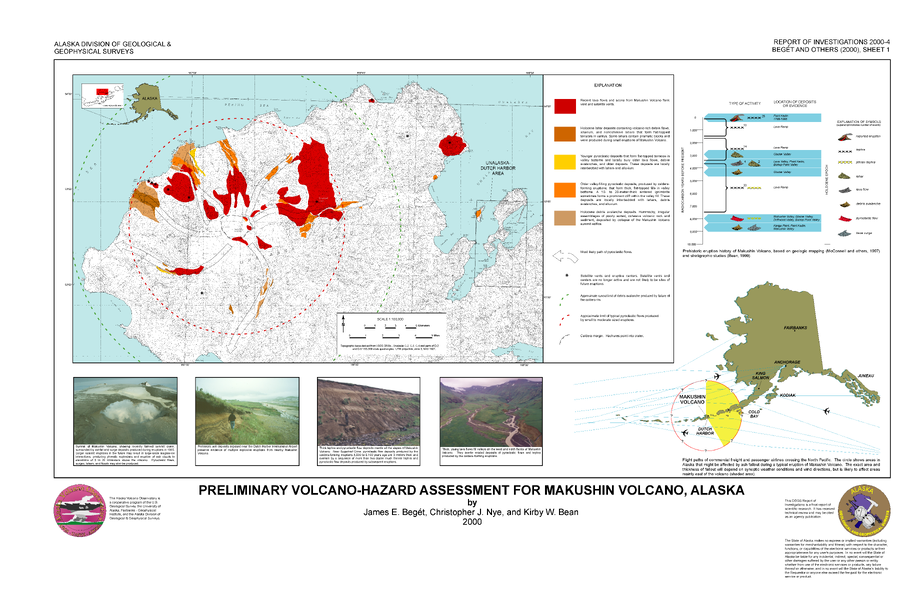
Official, Insert/poster-size map with accompanying report
Preliminary Volcano-Hazard Assessment for Makushin Volcano, Alaska
Sheet 1 in: Beget, J.E., Nye, C.J. & Bean, K.W. (2000). Preliminary volcano-hazard assessment for Makushin Volcano, Alaska. Alaska Division of Geological & Geophysical Surveys, Report of Investigation 2000-4, 22 p., 1 sheet, scale 1:100,000.
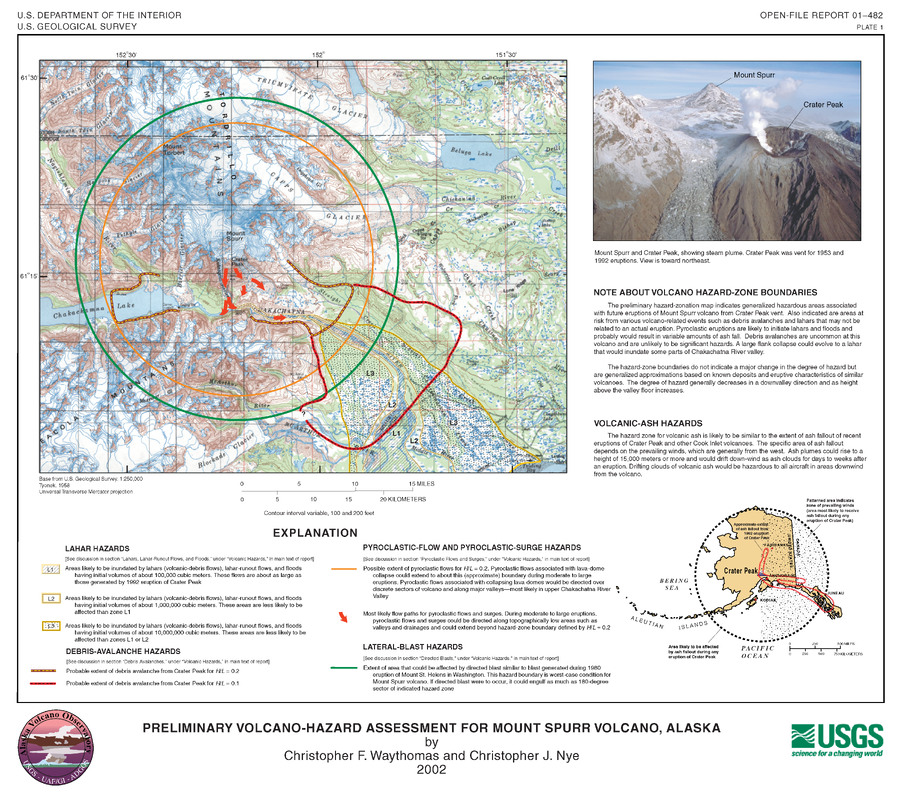
Official, Insert/poster-size map with accompanying report
Preliminary Volcano-Hazard Assessment for Mount Spurr Volcano, Alaska
Plate1 in: Waythomas, C.F. & Nye, C.J. (2002). Preliminary volcano-hazard assessment for Mount Spurr Volcano, Alaska. U.S. Geological Survey, Open-File Report 2001-482, 40 p., 1 plate. https://doi.org/10.3133/ofr01482
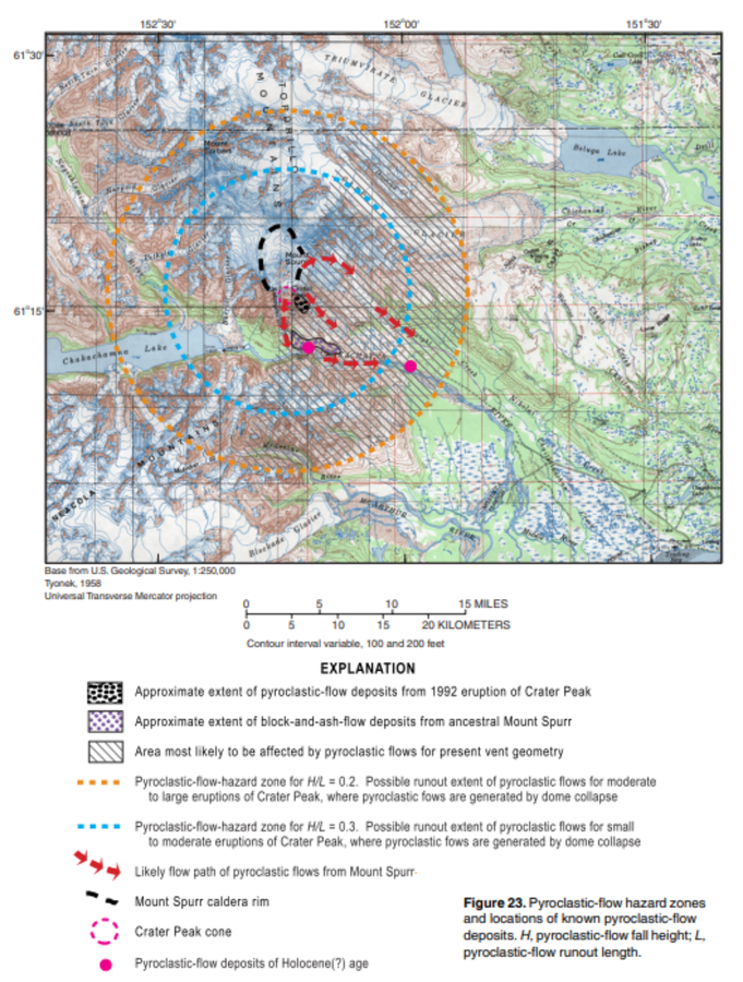
Official, Figure in hazard assessment
Pyroclastic-flow hazard zones and locations of known pyroclastic-flow deposits
Figure 23 in: Waythomas, C.F. & Nye, C.J. (2002). Preliminary volcano-hazard assessment for Mount Spurr Volcano, Alaska. U.S. Geological Survey, Open-File Report 2001-482, 40 p., 1 plate. https://doi.org/10.3133/ofr01482
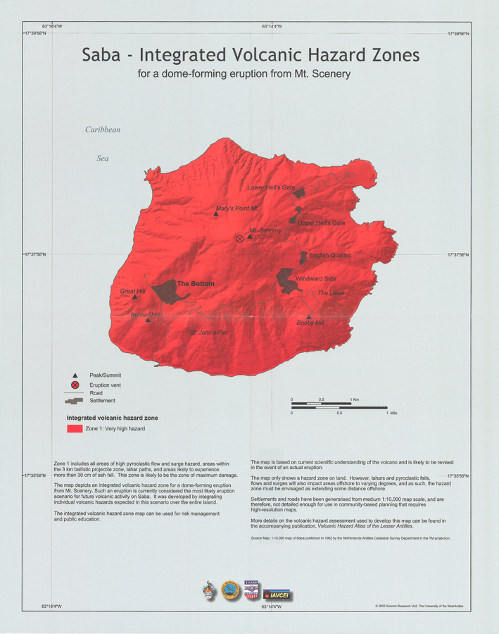
Official, Insert/poster-size map with accompanying report
Saba - Integrated Volcanic Hazard Zones for a dome-forming eruption from Mt. Scenery
Pocket insert in: Smith, A.L. & Roobol, M.J. (2005). Saba. In: Lindsay, J.M., Shepherd, J.B., Robertson, R.E.A., & Ali, S. (Eds) Volcanic hazard atlas of the Lesser Antilles. Seismic Research Unit, The University of the West Indies, Trinidad and Tobago, W.I., p. 181-191.
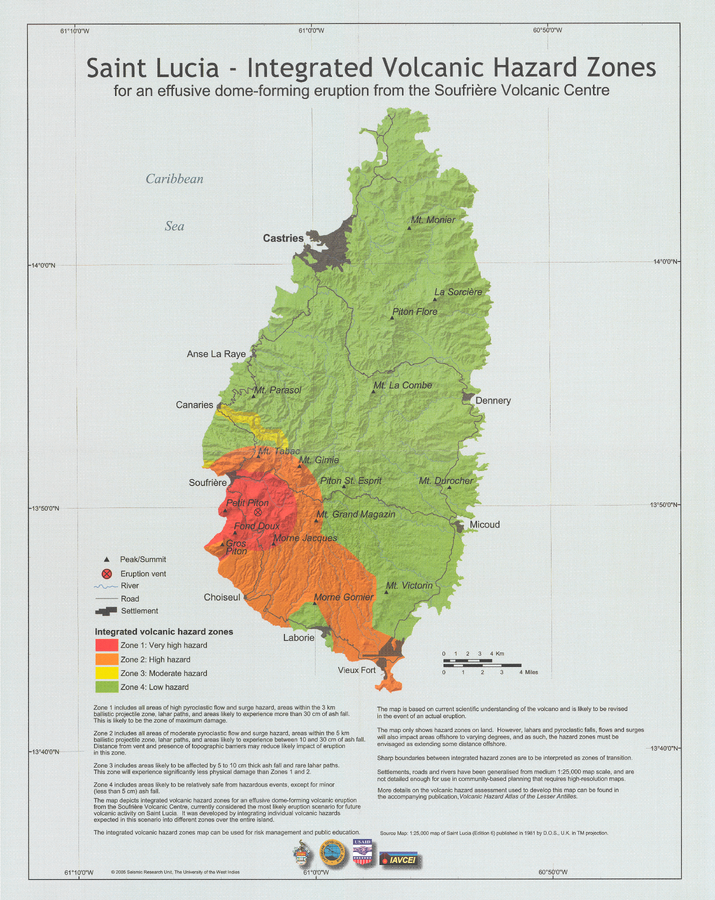
Official, Insert/poster-size map with accompanying report
Saint Lucia - Integrated Volcanic Hazard Zones for an effusive dome-forming eruption from the Soufrière Volcanic Centre
Pocket Insert in: Lindsay, J.M. (2005). Saint Lucia. In: Lindsay, J.M., Shepherd, J.B., Robertson, R.E.A., & Ali, S. (Eds) Volcanic hazard atlas of the Lesser Antilles. Seismic Research Unit, The University of the West Indies, Trinidad and Tobago, W.I., p. 219-239.

Official, Map sheet or poster
Santorini Volcano Hazard Zonation Maps
Vougioukalakis, G., Papazachos, C., Lekkas, E., & Antonakos, A. (Year Unknown). Santorini Volcano Hazard Zonation Maps.
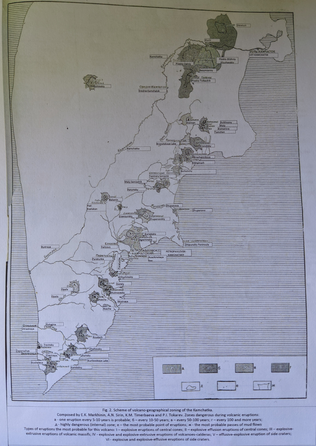
Official, Figure in a journal article
Scheme of volcano-geographical zoning in Kamchatka
Figure 2 in: Markhinin, E. K., Sirin, A. N., Timerbayeva, K. M., & Tokarev, P. I. (1962). Experience of volcanic-geographic zoning of Kamchatka and Kuril Islands. Bulletin of the Volcanological Station, Petropavlousk, Kamchatskiy, USSR, 32, 52-70.
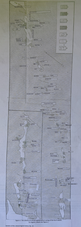
Official, Figure in a journal article
Scheme of volcano-geographical zoning in the Kuril Islands
Figure 3 in: Markhinin, E. K., Sirin, A. N., Timerbayeva, K. M., & Tokarev, P. I. (1962). Experience of volcanic-geographic zoning of Kamchatka and Kuril Islands. Bulletin of the Volcanological Station, Petropavlousk, Kamchatskiy, USSR, 32, 52-70.
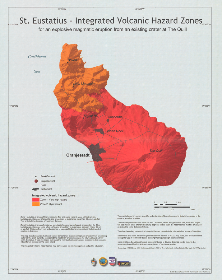
Official, Insert/poster-size map with accompanying report
St. Eustatius - Integrated Volcanic Hazard Zones for an explosive magmatic eruption from an existing crater at The Quill
Pocket Insert in: Smith, A.L. & Roobol, M.J. (2005). St. Eustatius. In: Lindsay, J.M., Shepherd, J.B., Robertson, R.E.A., & Ali, S. (Eds) Volcanic hazard atlas of the Lesser Antilles. Seismic Research Unit, The University of the West Indies, Trinidad and Tobago, W.I., p. 193-203
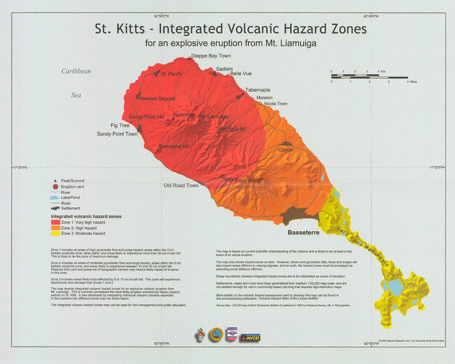
Official, Insert/poster-size map with accompanying report
St. Kitts - Integrated Volcanic Hazard Zones for an explosive eruption from Mt. Liamuiga
Pocket insert in: Robertson, R.E.A. (2005). St. Kitts. In: Lindsay, J.M., Shepherd, J.B., Robertson, R.E.A., & Ali, S. (Eds) Volcanic hazard atlas of the Lesser Antilles. Seismic Research Unit, The University of the West Indies, Trinidad and Tobago, W.I., p. 205-217.