← Back to Search ResultsMaps Showing Lava Inundation Zones for Mauna Loa, Hawai'i
Mauna Loa, United States, 2002
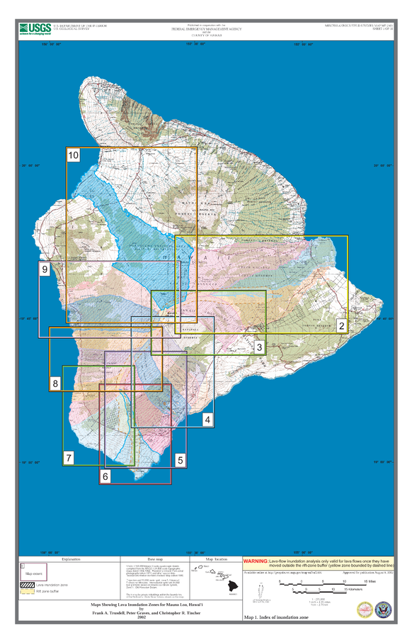
Sheet 1 in: Trusdell, F.A., Graves, P., & Tincher, C.R. (2002). Map Showing Lava Inundation Zones for Mauna Loa, Hawai‘i. U.S. Geological Survey, Miscellaneous Field Studies Map MF-2401. 10 Map Sheets (each 22 x 34 inches); Pamphlet (14 p.) scale 1:70000. https://doi.org/10.3133/mf2401
This map was produced by an official agency, but may not be the most recent, most complete, or main operational map.
For the current operational hazard map, please consult the proper institutional authorities.
Click on image for full-size map. If link seems broken, try the archived
version.Map Set
Trusdell, F.A., Graves, P., & Tincher, C.R. (2002). Map Showing Lava Inundation Zones for Mauna Loa, Hawai‘i. U.S. Geological Survey, Miscellaneous Field Studies Map MF-2401. 10 Map Sheets (each 22 x 34 inches); Pamphlet (14 p.) scale 1:70000. https://doi.org/10.3133/mf2401
https://doi.org/10.3133/mf2401
Other Maps In Set:
- Maps Showing Lava Inundation Zones for Mauna Loa, Hawai'i - Map 2. Kaumana, Waiakea, and Volcano-Mountain View inundation zones
- Maps Showing Lava Inundation Zones for Mauna Loa, Hawai'i - Map 3. Kapapala inundation zone
- Maps Showing Lava Inundation Zones for Mauna Loa, Hawai'i - Map 4. Pahala, Punalu'u, and Wood Valley inundation zones
- Maps Showing Lava Inundation Zones for Mauna Loa, Hawai'i - Map 5. Na'alehu inundation zone
- Maps Showing Lava Inundation Zones for Mauna Loa, Hawai'i - Map 6. Ka Lae inundation zone
- Maps Showing Lava Inundation Zones for Mauna Loa, Hawai'i - Map 7. HOVE, Kapu'a, and Miloli'i inundation zones
- Maps Showing Lava Inundation Zones for Mauna Loa, Hawai'i - Map 8. Ho'okena, Ka'ohe, and Ka'apuna inundation zones
- Maps Showing Lava Inundation Zones for Mauna Loa, Hawai'i - Map 9. Honaunau and Kealakekua inundation zones
- Maps Showing Lava Inundation Zones for Mauna Loa, Hawai'i - Map 10. Puako lava inundation zone
Map Data
Go to Global Volcanism Program page for Mauna Loa →
