
Advanced Search for Maps
Showing 511-520 of 726
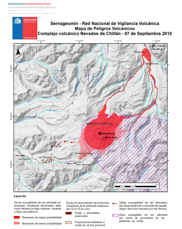
Official, Map in an information statement
Sernageomin - Red Nacional de Vigilancia Volcánica - Mapa de Peligros Volcánicos - Complejo volcánico Nevados de Chillán - 07 de Septiembre 2018
(Sernageomin - National Network of Volcanic Surveillance - Map of Volcanic Hazards - Nevados de Chillán volcanic complex - September 7, 2018)
Servicio Nacional de Geología y Minería (SERNAGEOMIN) Observatorio Volcanológico de los Andes del Sur (OVDAS). (2018). Reporte de Actividad Volcánica (RAV), 07-09-2018, RAV Región de Ñuble Año 2018 Septiembre - Volumen 1. Observatorio Volcanológico de los Andes del Sur (OVDAS).
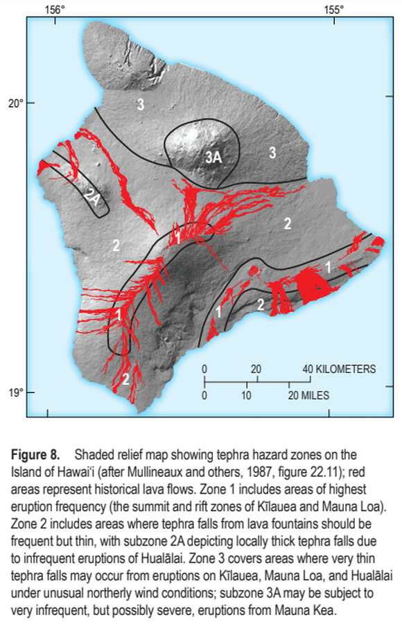
Official, Figure in a journal article
Shaded relief map showing tephra hazard zones on the Island of Hawai‘i
Figure 8 in: Kauahikaua, J.P. & Tilling, R.I. (2014). Natural hazards and risk reduction in Hawai‘i. In: Poland, M.P., Takahashi, T.J., & Landowski, C.M. (eds.) Characteristics of Hawaiian Volcanoes. US Geological Survey Professional Paper 1801, p. 397-427. https://doi.org/10.3133/pp180110
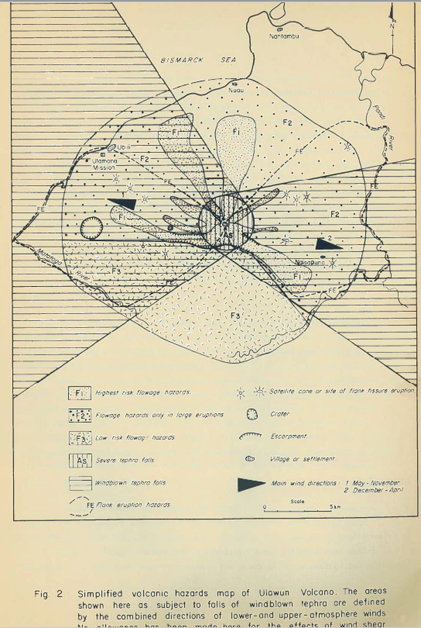
Official, Figure in hazard assessment
Simplified volcanic hazards map of Ulawun Volcano
Figure 2 in: McKee, C.O. (1983). Volcanic hazards at Uluwan volcano. Geological Survey of Papua New Guinea, Report 83/13, 1:100,000
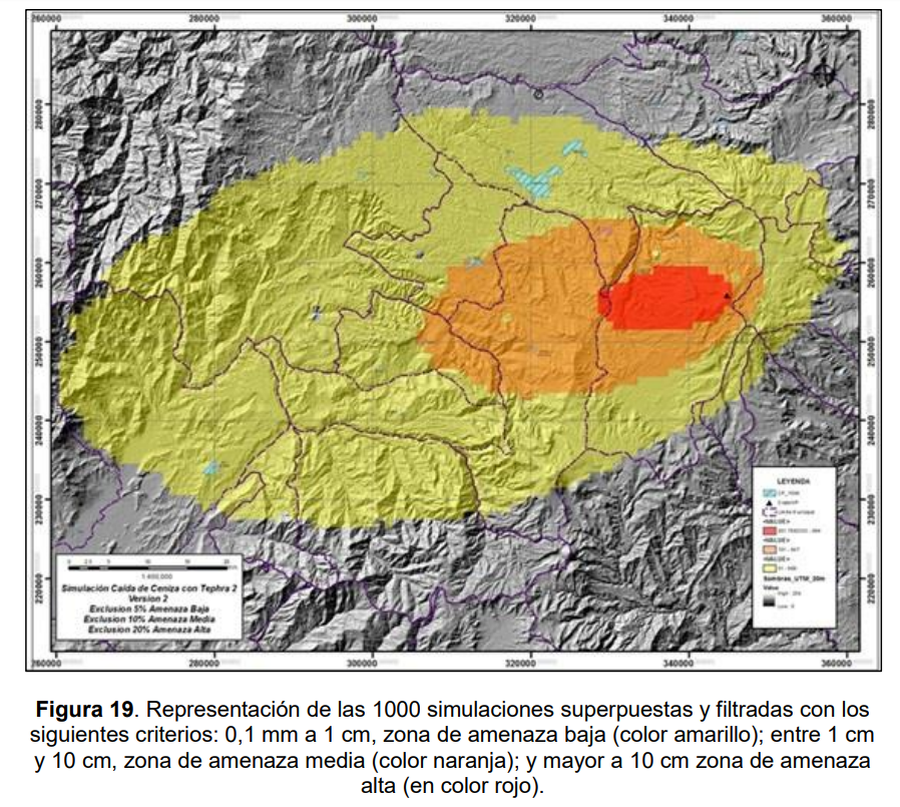
Official, Figure in hazard assessment
Simulación Caida de Ceniza con Tephra 2 Version 2
(Ash Fall Simulation with Tephra 2 Version 2)
Figure 19 in: Galarza Zambrano, J.J., Zuluaga Mazo, I, Monsalve Bustamante, M.L., & Laverde Castano, C.A. (2014). Implementación de Herramientas Computacionales para la Simulación de Fenómenos Volcánicos, para la Actualización del Mapa de Amenaza del Volcán Puracé Actual: Tephra 2, Titán 2D, Lahar Z, Lava PL. Servicio Geológico Colombiano (SGC). Bogotá.
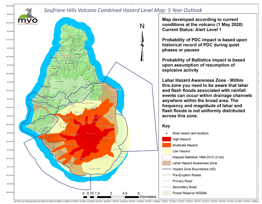
Official, Figure on website
Soufriere Hills Volcano Combined Hazard Level Map: 5 Year Outlook
Miller, V. et al. (2020) reproduced in: Montserrat Volcano Observatory. (2026). Volcanic Hazard-Previous Volcanic Hazard Maps. https://www.mvo.ms/hazards/volcanic-hazard/. Accessed 02-24-2016.

Official, Figure on website
Spring Village Community Multi-Hazard Map
The University of the West Indies Seismic Research Centre (UWI-SRC) and National Emergency Management Organization (NEMO). (2021). Spring Village Community Multi-Hazard Map. https://uwiseismic.com/wp-content/uploads/2021/10/Spring-Village-Hazard-Map-scaled.jpg
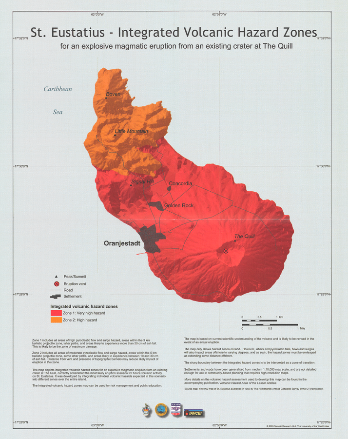
Official, Insert/poster-size map with accompanying report
St. Eustatius - Integrated Volcanic Hazard Zones for an explosive magmatic eruption from an existing crater at The Quill
Pocket Insert in: Smith, A.L. & Roobol, M.J. (2005). St. Eustatius. In: Lindsay, J.M., Shepherd, J.B., Robertson, R.E.A., & Ali, S. (Eds) Volcanic hazard atlas of the Lesser Antilles. Seismic Research Unit, The University of the West Indies, Trinidad and Tobago, W.I., p. 193-203
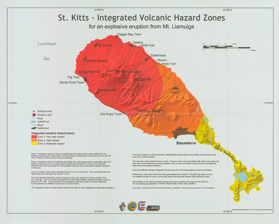
Official, Insert/poster-size map with accompanying report
St. Kitts - Integrated Volcanic Hazard Zones for an explosive eruption from Mt. Liamuiga
Pocket insert in: Robertson, R.E.A. (2005). St. Kitts. In: Lindsay, J.M., Shepherd, J.B., Robertson, R.E.A., & Ali, S. (Eds) Volcanic hazard atlas of the Lesser Antilles. Seismic Research Unit, The University of the West Indies, Trinidad and Tobago, W.I., p. 205-217.
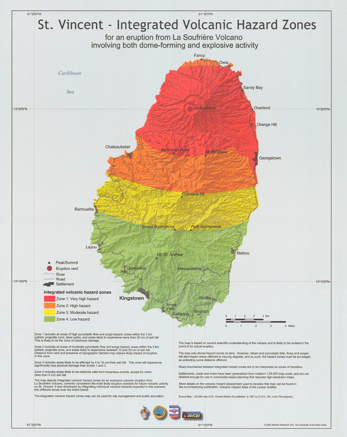
Official, Insert/poster-size map with accompanying report
St. Vincent - Integrated volcanic hazard zones for an eruption from La Soufrière Volcano involving both dome-forming and explosive activity
Pocket insert in: Robertson, R. (2005). St. Vincent. In: Lindsay, J.M., Shepherd, J.B., Robertson, R.E.A., & Ali, S. (Eds) Volcanic hazard atlas of the Lesser Antilles. Seismic Research Unit, The University of the West Indies, Trinidad and Tobago, W.I., p. 241-261
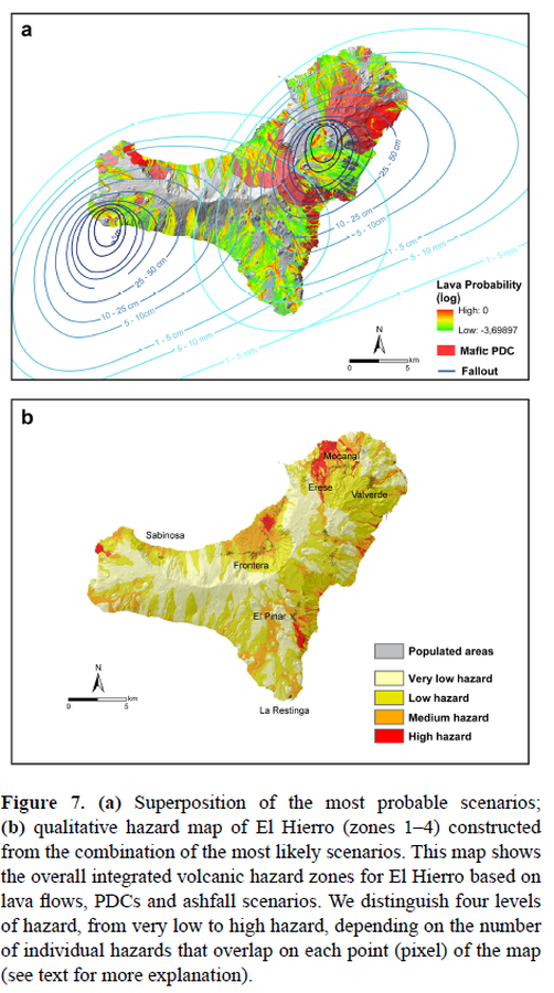
Figure in a journal article
Superposition of the most probable scenarios; qualitative hazard map of El Hierro (zones 1–4) constructed from the combination of the most likely scenarios
Figure 7 in: Becerril, L., Bartolini, S., Sobradelo, R., Martí, J., Morales, J. M., & Galindo, I. (2014). Long-term volcanic hazard assessment on El Hierro (Canary Islands). Natural Hazards and Earth System Sciences, 14(7), 1853-1870. https://doi.org/10.5194/nhess-14-1853-2014, 2014