
Advanced Search for Maps
Showing 61-70 of 88
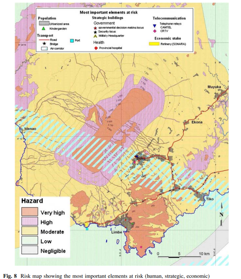
Figure in a journal article
Risk map showing the most important elements at risk (human, strategic, economic)
Figure 8 in: Thierry, P., Stieltjes, L., Kouokam, E., Nguéya, P., & Salley, P. M. (2008). Multi-hazard risk mapping and assessment on an active volcano: the GRINP project at Mount Cameroon. Natural Hazards, 45(3), 429-456. https://doi.org/10.1007/s11069-007-9177-3
Official, Figure in a journal article
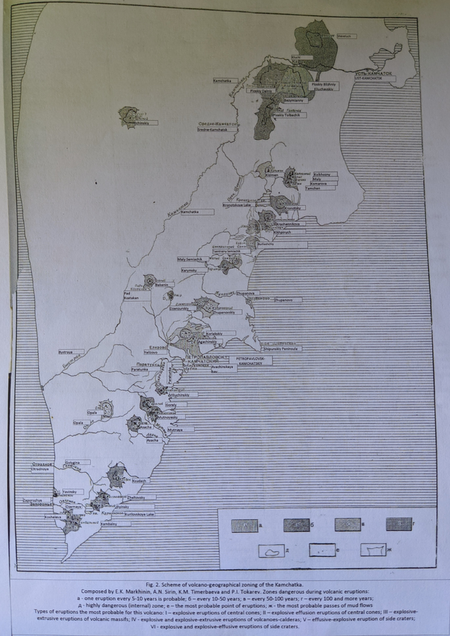
Scheme of volcano-geographical zoning in Kamchatka
Figure 2 in: Markhinin, E. K., Sirin, A. N., Timerbayeva, K. M., & Tokarev, P. I. (1962). Experience of volcanic-geographic zoning of Kamchatka and Kuril Islands. Bulletin of the Volcanological Station, Petropavlousk, Kamchatskiy, USSR, 32, 52-70.
Official, Figure in a journal article
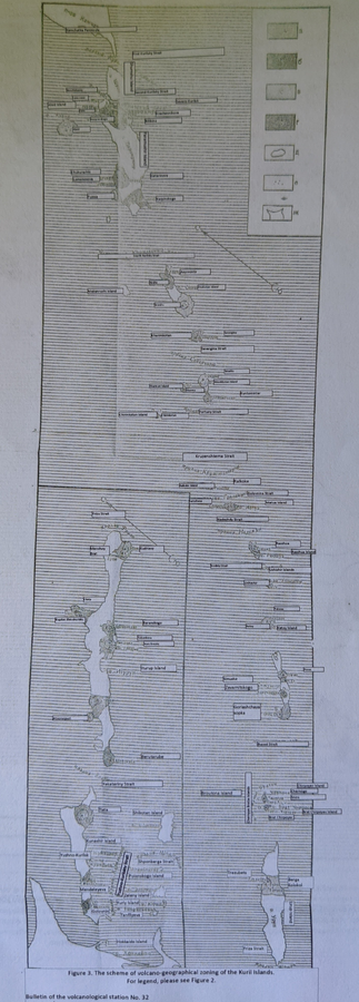
Scheme of volcano-geographical zoning in the Kuril Islands
Figure 3 in: Markhinin, E. K., Sirin, A. N., Timerbayeva, K. M., & Tokarev, P. I. (1962). Experience of volcanic-geographic zoning of Kamchatka and Kuril Islands. Bulletin of the Volcanological Station, Petropavlousk, Kamchatskiy, USSR, 32, 52-70.
Official, Figure on website
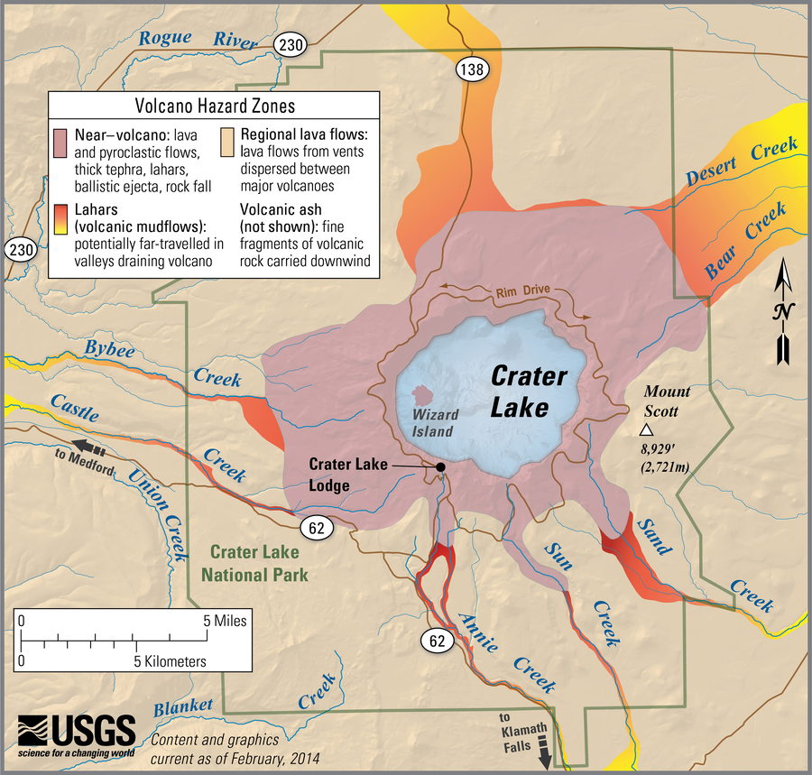
Simplified volcano hazards map of Crater Lake, Oregon
Bacon, C.R., Mastin, L.G., Scott, K., Nathenson, M., Driedger, C.L., Scott, W.E., Iverson, R.M., Ramsey, D.W., & Faust, L.M. (2014). Simplified volcano hazards map of Crater Lake, Oregon. U.S. Geological Survey. Crater Lake, OR Simplified Hazards Map. https://www.usgs.gov/media/images/crater-lake-or-simplified-hazards-map (Modified from: U.S. Geological Survey, Open-File Report 97-487)
Official, Figure on website
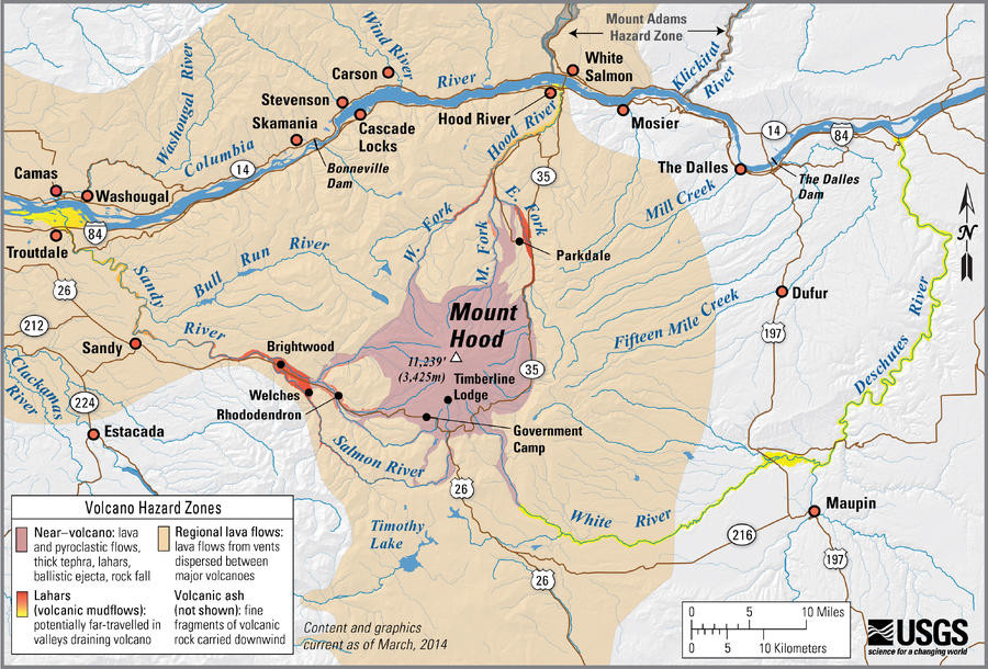
Simplified volcano hazards map of Mount Hood, Oregon
Scott, W.E., Pierson, T.C., Schilling, S.P., Costa, J.E., Gardner, C.A., Vallance, J.W., Major, J.J., Driedger, C.L., Iverson, R.M., Ramsey, D.W., & Faust, L.M. (2014). Simplified volcano hazards map of Mount Hood, Oregon. U.S. Geological Survey. Mount Hood, OR Simplified Hazards Map. https://www.usgs.gov/media/images/mount-hood-or-simplified-hazards-map (Modified from: U.S. Geological Survey, Open-File Report 97-89)
Official, Figure on website
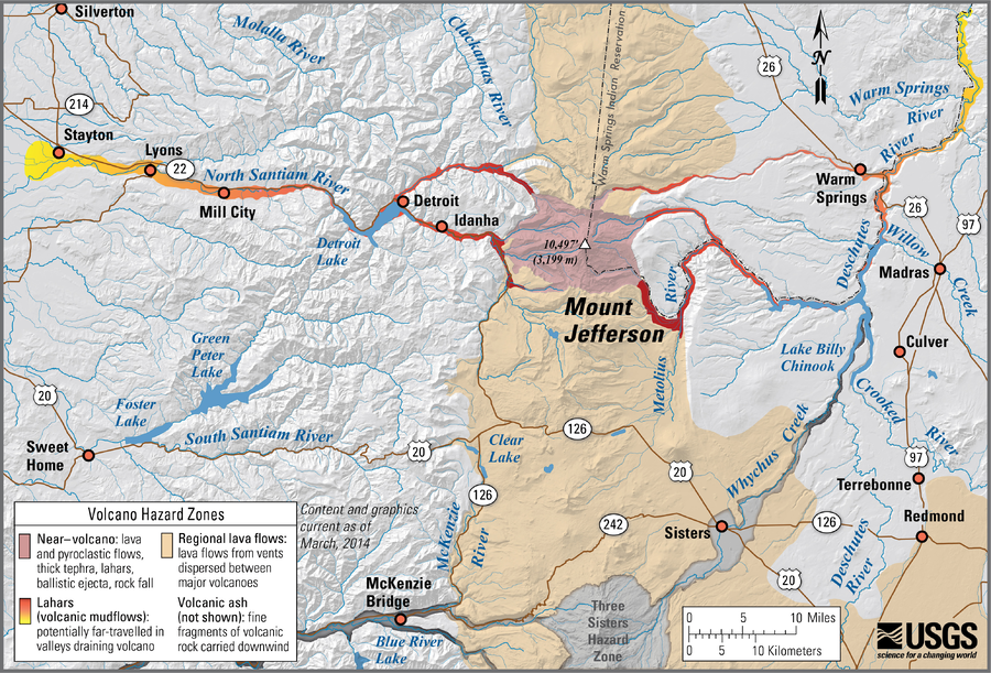
Simplified volcano hazards map of Mount Jefferson, Oregon
Walder, J.S., Gardner, C., Conrey, R.M., Fisher, B.J., Schilling, S.P., Driedger, C.L., Scott, W.E., Iverson, R.M., Ramsey, D.W., & Faust, L.M. (2014). Simplified volcano hazards map of Mount Jefferson, Oregon. U.S. Geological Survey. Mount Jefferson, OR Simplified Hazards Map. https://www.usgs.gov/media/images/mount-jefferson-or-simplified-hazards-map (Modified from: U.S. Geological Survey, Open-File Report 99-24)

Official, Figure on website
Simplified volcano hazards map of Newberry Volcano, Oregon
Sherrod, D.R., Mastin, L.G., Scott, W.E., Schilling, S.P., Driedger, C.L., Iverson, R.M., Ramsey, D.W., & Faust, L.M. (2014). Simplified volcano hazards map of Newberry Volcano, Oregon. U.S. Geological Survey. Newberry Volcano, OR simplified hazards map. https://www.usgs.gov/media/images/newberry-volcano-or-simplified-hazards-map (Modified from: U.S. Geological Survey, Open-File Report 97-513)
Official, Figure on website
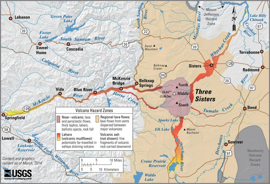
Simplified volcano hazards map of Three Sisters, Oregon
Scott, W.E., Iverson, R.M., Schilling, S.P., Fisher, B.J., Driedger, C.L., Ramsey, D.W., & Faust, L.M. (2014). Simplified volcano hazards map of Three Sisters, Oregon. U.S. Geological Survey. Three Sisters, OR Simplified Hazards Map. https://www.usgs.gov/media/images/three-sisters-or-simplified-hazards-map (Modified from: U.S. Geological Survey, Open-File Report 99-437)
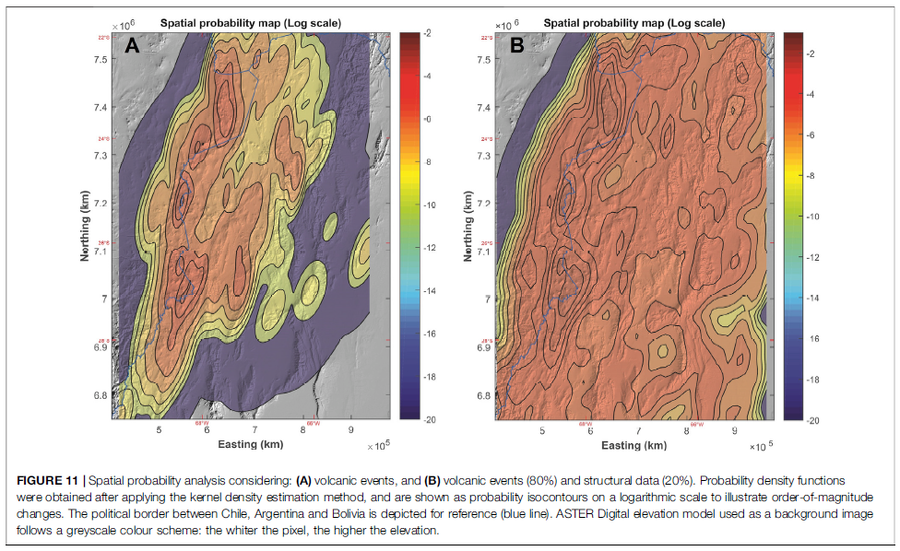
Figure in a journal article
Spatial probability analysis considering: (A) volcanic events, and (B) volcanic events (80%) and structural data (20%)
Figure 11 in: Bertin, D., Lindsay, J.M., Cronin, S.J., de Silva, S.L., Connor, C.B., Caffe, P.J., Grosse, P., Báez, W., Bustos, E., & Constantinescu, R. (2022). Probabilistic Volcanic Hazard Assessment of the 22.5–28° S Segment of the Central Volcanic Zone of the Andes. Frontiers in Earth Science, 10. https://doi.org/10.3389/feart.2022.875439
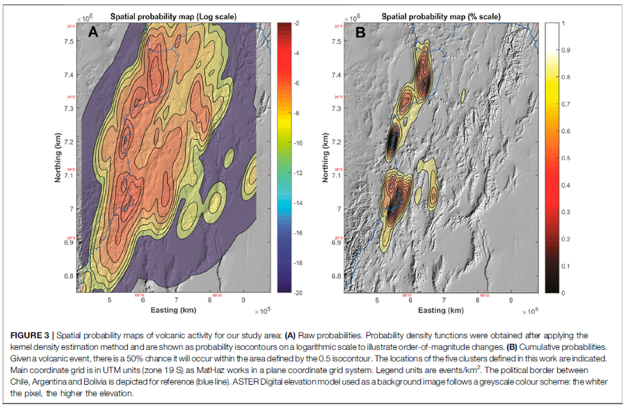
Figure in a journal article
Spatial probability maps of volcanic activity for our study area
Figure 3 in: Bertin, D., Lindsay, J.M., Cronin, S.J., de Silva, S.L., Connor, C.B., Caffe, P.J., Grosse, P., Báez, W., Bustos, E., & Constantinescu, R. (2022). Probabilistic Volcanic Hazard Assessment of the 22.5–28° S Segment of the Central Volcanic Zone of the Andes. Frontiers in Earth Science, 10. https://doi.org/10.3389/feart.2022.875439