
Advanced Search for Maps
Showing 1-7 of 7
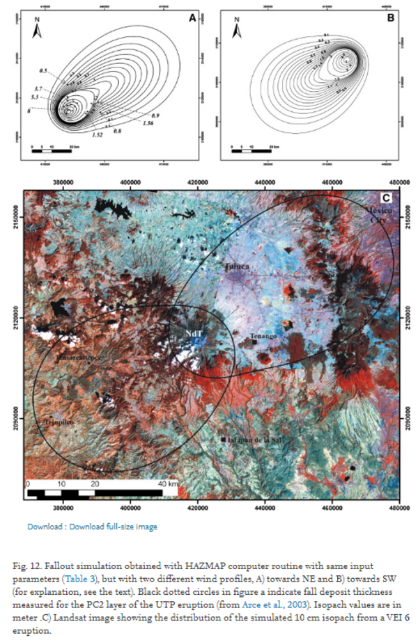
Figure in a journal article
Fallout simulation obtained with HAZMAP computer routine with same input parameters (Table 3), but with two different wind profiles
Figure 12 in: Capra, L., Norini, G., Groppelli, G., Macías, J.L., & Arce, J.L. (2008). Volcanic hazard zonation of the Nevado de Toluca volcano, México. Journal of Volcanology and Geothermal Research, 176(4), p. 469-484. https://doi.org/10.1016/j.jvolgeores.2008.04.016
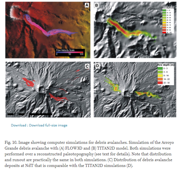
Figure in a journal article
Image showing computer simulations for debris avalanches
Figure 10 in: Capra, L., Norini, G., Groppelli, G., Macías, J.L., & Arce, J.L. (2008). Volcanic hazard zonation of the Nevado de Toluca volcano, México. Journal of Volcanology and Geothermal Research, 176(4), p. 469-484. https://doi.org/10.1016/j.jvolgeores.2008.04.016
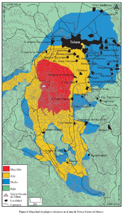
Figure in a journal article
Mapa final de peligros volcánicos en el área de Toluca, Centro de México
(Final map of volcanic hazards in the Toluca area, Central Mexico)
Figure 4 in: Aceves-Quesada, F., López-Blanco, J., & Martin del Pozzo, A. L. (2006). Determinación de peligros volcánicos aplicando técnicas de evaluación multicriterio y SIG en el área del Nevado de Toluca, centro de México. Revista Mexicana de Ciencias Geológicas, 23(2), 113-124.
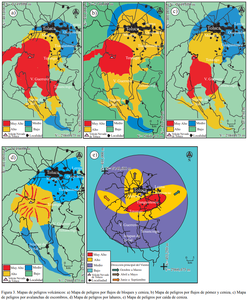
Figure in a journal article
Mapas de peligros volcánicos
(Volcanic hazard maps)
Figure 3 in: Aceves-Quesada, F., López-Blanco, J., & Martin del Pozzo, A. L. (2006). Determinación de peligros volcánicos aplicando técnicas de evaluación multicriterio y SIG en el área del Nevado de Toluca, centro de México. Revista Mexicana de Ciencias Geológicas, 23(2), 113-124.
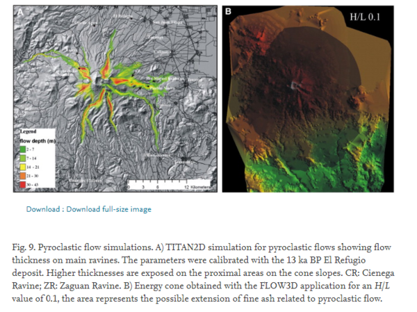
Figure in a journal article
Pyroclastic flow simulations
Figure 9 in: Capra, L., Norini, G., Groppelli, G., Macías, J.L., & Arce, J.L. (2008). Volcanic hazard zonation of the Nevado de Toluca volcano, México. Journal of Volcanology and Geothermal Research, 176(4), p. 469-484. https://doi.org/10.1016/j.jvolgeores.2008.04.016
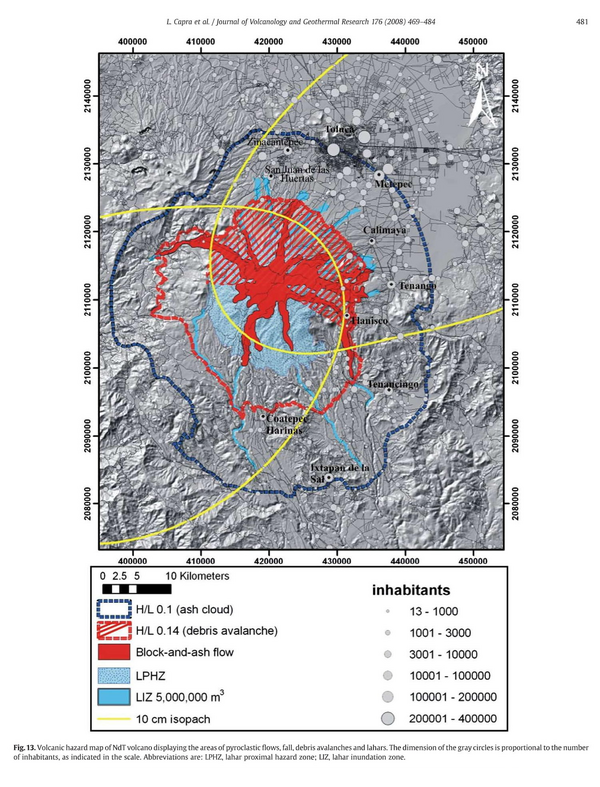
Figure in a journal article
Volcanic hazard map of NdT volcano displaying the areas of pyroclastic flows, fall, debris avalanches and lahars
Figure 13 in: Capra, L., Norini, G., Groppelli, G., Macías, J.L., & Arce, J.L. (2008). Volcanic hazard zonation of the Nevado de Toluca volcano, México. Journal of Volcanology and Geothermal Research, 176(4), p. 469-484. https://doi.org/10.1016/j.jvolgeores.2008.04.016
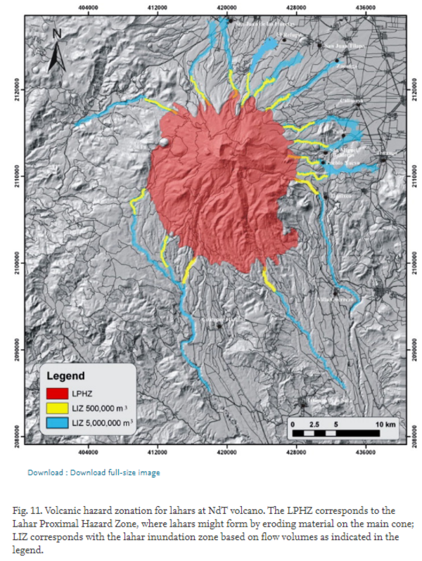
Figure in a journal article
Volcanic hazard zonation for lahars at NdT volcano
Figure 11 in: Capra, L., Norini, G., Groppelli, G., Macías, J.L., & Arce, J.L. (2008). Volcanic hazard zonation of the Nevado de Toluca volcano, México. Journal of Volcanology and Geothermal Research, 176(4), p. 469-484. https://doi.org/10.1016/j.jvolgeores.2008.04.016