
Advanced Search for Maps
Showing 1-10 of 10
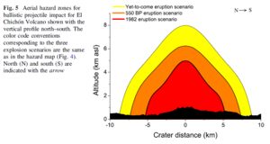
Figure in a journal article
Aerial hazard zones for ballistic projectile impact for El Chichón Volcano shown with the vertical profile north–south
Figure 5 in: Alatorre-Ibargüengoitia, M.A., Morales-Iglesias, H., Ramos-Hernández, S.G., Jon-Selvas, J., & Jiménez-Aguilar, J.M. (2016). Hazard zoning for volcanic ballistic impacts at El Chichón Volcano (Mexico). Natural Hazards, 81(3), p. 1733-1744. https://doi.org/10.1007/s11069-016-2152-0
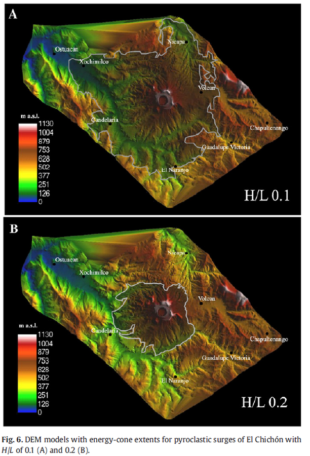
Figure in a journal article
DEM models with energy-cone extents for pyroclastic surges of El Chichón with H/L of 0.1 (A) and 0.2 (B).
Figure 6 in: Macías, J. L., Capra, L., Arce, J. L., Espíndola, J. M., García-Palomo, A., & Sheridan, M. F. (2008). Hazard map of El Chichón volcano, Chiapas, México: Constraints posed by eruptive history and computer simulations. Journal of Volcanology and Geothermal Research, 175(4), 444-458. https://doi.org/10.1016/j.jvolgeores.2008.02.023
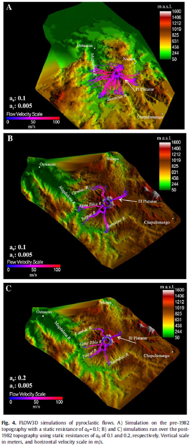
Figure in a journal article
FLOW3D simulations of pyroclastic flows
Figure 4 in: Macías, J. L., Capra, L., Arce, J. L., Espíndola, J. M., García-Palomo, A., & Sheridan, M. F. (2008). Hazard map of El Chichón volcano, Chiapas, México: Constraints posed by eruptive history and computer simulations. Journal of Volcanology and Geothermal Research, 175(4), 444-458. https://doi.org/10.1016/j.jvolgeores.2008.02.023
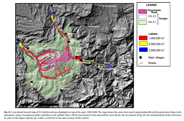
Figure in a journal article
Generalized hazard map of El Chichón volcano displayed on top of the post-1982 DEM
Figure 11 in: Macías, J. L., Capra, L., Arce, J. L., Espíndola, J. M., García-Palomo, A., & Sheridan, M. F. (2008). Hazard map of El Chichón volcano, Chiapas, México: Constraints posed by eruptive history and computer simulations. Journal of Volcanology and Geothermal Research, 175(4), 444-458. https://doi.org/10.1016/j.jvolgeores.2008.02.023
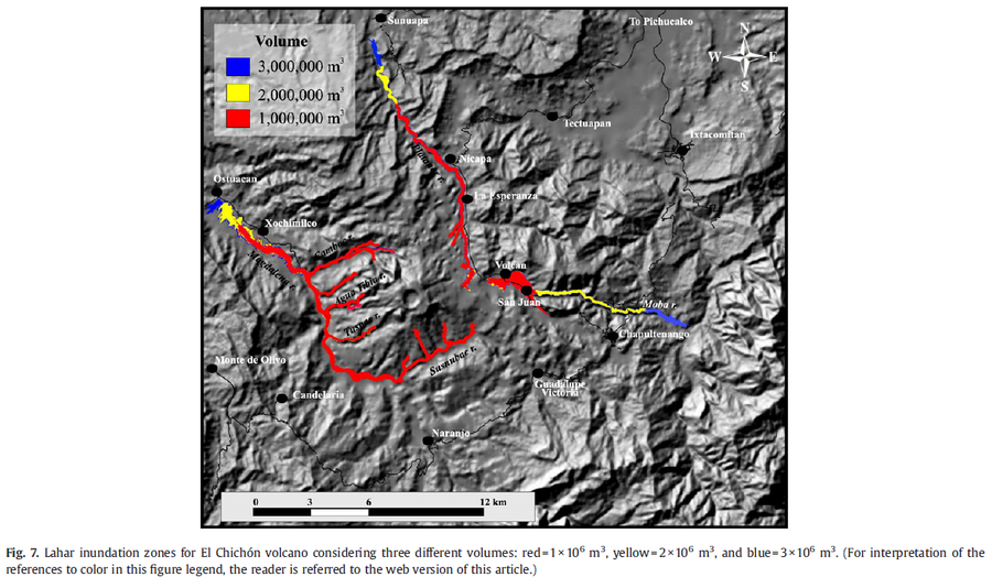
Figure in a journal article
Lahar inundation zones for El Chichón volcano considering three different volumes: red=1×10^6 m3, yellow=2×10^6 m3, and blue=3×10^6 m3.
Figure 7 in: Macías, J. L., Capra, L., Arce, J. L., Espíndola, J. M., García-Palomo, A., & Sheridan, M. F. (2008). Hazard map of El Chichón volcano, Chiapas, México: Constraints posed by eruptive history and computer simulations. Journal of Volcanology and Geothermal Research, 175(4), 444-458. https://doi.org/10.1016/j.jvolgeores.2008.02.023
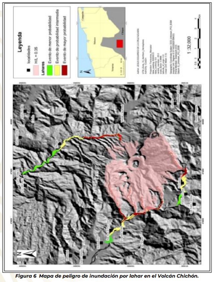
Official, Figure in hazard assessment
Mapa de peligro de inundación por lahar en el Volcán Chichón
(Hazard map of flooding by lahar at Chichón Volcano)
Figure 6 in: Subsecretaría de Planeacíon, Informacíon y Protección Civil, Coorinacíon Nacional de Protección Civil, & Centro Nacional de Prevención de Desastres. (2018). Report Of Practical Hazard Maps Of Volcanoes, Ceboruco, Colima, Citlaltépetl, Chichonal And Tacaná. Subdirección de Riesgos Volcánicos. Dirección de Investigación. Ciudad de México.
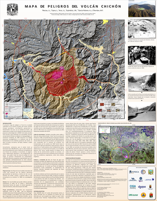
Official, Map sheet or poster
Mapa de Peligros del Volcán Chichón
(Chichón Volcano Hazard Map)
Macías, J.L., Capra, L., Arce, J.L., Espíndola, J.M., García-Palomo, A., & Sheridan, M.F. (2008). Mapa de Peligros del Volcán Chichón.

Official, Figure in hazard assessment
Mapa práctico de peligros del volcán Chichón
(Practical hazard map of the Chichón volcano)
Figure 15 in: Subsecretaría de Planeacíon, Informacíon y Protección Civil, Coorinacíon Nacional de Protección Civil, & Centro Nacional de Prevención de Desastres. (2018). Report Of Practical Hazard Maps Of Volcanoes, Ceboruco, Colima, Citlaltépetl, Chichonal And Tacaná. Subdirección de Riesgos Volcánicos. Dirección de Investigación. Ciudad de México.
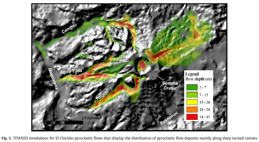
Figure in a journal article
TITAN2D simulations for El Chichón pyroclastic flows that display the distribution of pyroclastic flow deposits mainly along deep incised ravines
Figure 5 in: Macías, J. L., Capra, L., Arce, J. L., Espíndola, J. M., García-Palomo, A., & Sheridan, M. F. (2008). Hazard map of El Chichón volcano, Chiapas, México: Constraints posed by eruptive history and computer simulations. Journal of Volcanology and Geothermal Research, 175(4), 444-458. https://doi.org/10.1016/j.jvolgeores.2008.02.023
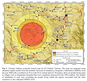
Figure in a journal article
Volcanic ballistic projectile hazard map for El Chichón Volcano
Figure 4 in: Alatorre-Ibargüengoitia, M.A., Morales-Iglesias, H., Ramos-Hernández, S.G., Jon-Selvas, J., & Jiménez-Aguilar, J.M. (2016). Hazard zoning for volcanic ballistic impacts at El Chichón Volcano (Mexico). Natural Hazards, 81(3), p. 1733-1744. https://doi.org/10.1007/s11069-016-2152-0