
Advanced Search for Maps
Showing 1-10 of 131
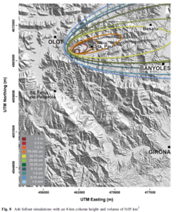
Figure in a journal article
Ash fallout simulations with an 8-km column height and volume of 0.05 km³
Figure 8 in: Bartolini, S., Bolós, X., Martí, J., Pedra, E. R., & Planagumà, L. (2015). Hazard assessment at the quaternary La Garrotxa volcanic field (NE Iberia). Natural Hazards, 78(2), 1349-1367. https://doi.org/10.1007/s11069-015-1774-y
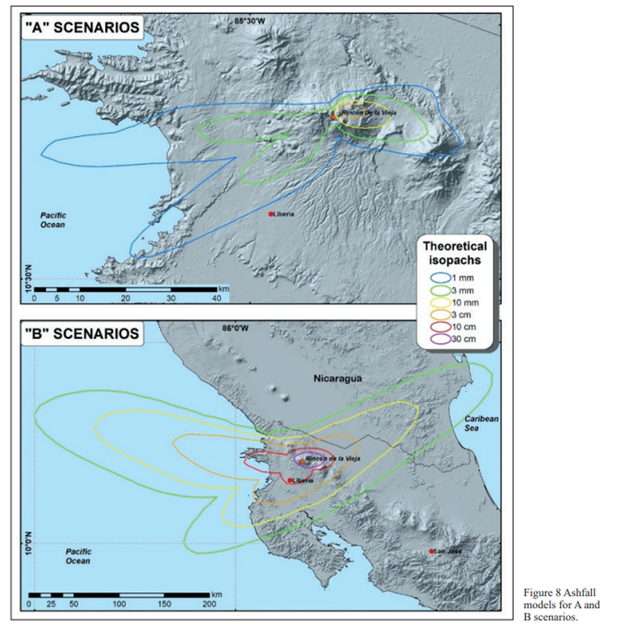
Figure in a journal article
Ashfall models for A and B scenarios
Figure 8 in: Alpízar, Y., Fernández, M., Ramírez, C., & Arroyo, D. (2019). Hazard Map of Rincón de la Vieja Volcano, Costa Rica: Qualitative Integration of Computer Simulations and Geological Data. Anuario do Instituto de Geociencias, 42(3). http://dx.doi.org/10.11137/2019_3_474_488
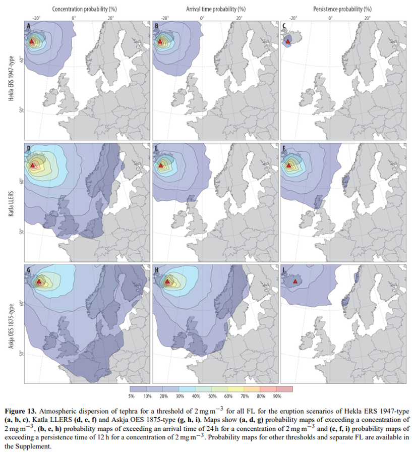
Figure in a journal article
Atmospheric dispersion of tephra for a threshold of 2 mg m−3 for all FL for the eruption scenarios of Hekla ERS 1947-type (a, b, c), Katla LLERS (d, e, f) and Askja OES 1875-type (g, h, i)
Figure 13 in: Biass, S., Scaini, C., Bonadonna, C., Folch, A., Smith, K., & Höskuldsson, A. (2014). A multi-scale risk assessment for tephra fallout and airborne concentration from multiple Icelandic volcanoes–Part 1: Hazard assessment. Natural hazards and earth system sciences, 14(8), 2265-2287. https://doi.org/10.5194/nhess-14-2265-2014
Figure in a journal article
Ballistic vulnerability or probability of casualty assuming an eruption during the time of exposure, along the Tongariro Alpine Crossing
Figure 12 in: Fitzgerald, R. H., Tsunematsu, K., Kennedy, B. M., Breard, E. C. P., Lube, G., Wilson, T. M., Jolly, A.D., Pawson, J., Rosenburg, M.D., & Cronin, S. J. (2014). The application of a calibrated 3D ballistic trajectory model to ballistic hazard assessments at Upper Te Maari, Tongariro. Journal of volcanology and geothermal research, 286, p. 248-262. https://doi.org/10.1016/j.jvolgeores.2014.04.006
Official, Figure in hazard assessment
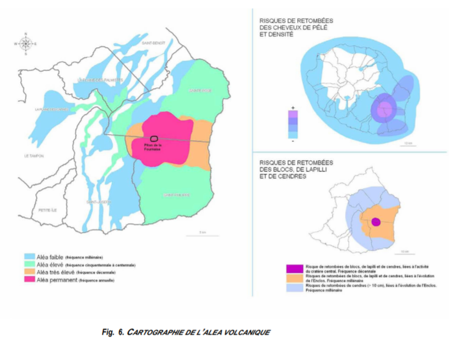
Cartographie de l’Alea Volcanique
(Mapping of the Volcanic Hazard)
Figure 6 in: Préfet de la Région Réunion. (2012). Schema de Prevention des Risques Naturels de la Réunion. Diagnostic et Programme d’Actions.
Official, Map in a booklet, long fact-sheet, or handbook
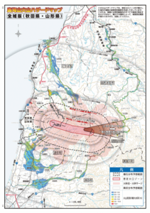
Chokaisan Hazard Map - Whole Area Version (Akita/Yamagata)
Page 13-14 in: Volcano Disaster Management Councils of Chokaisan. (2019). Chokaisan Volcanic Disaster Prevention Map.
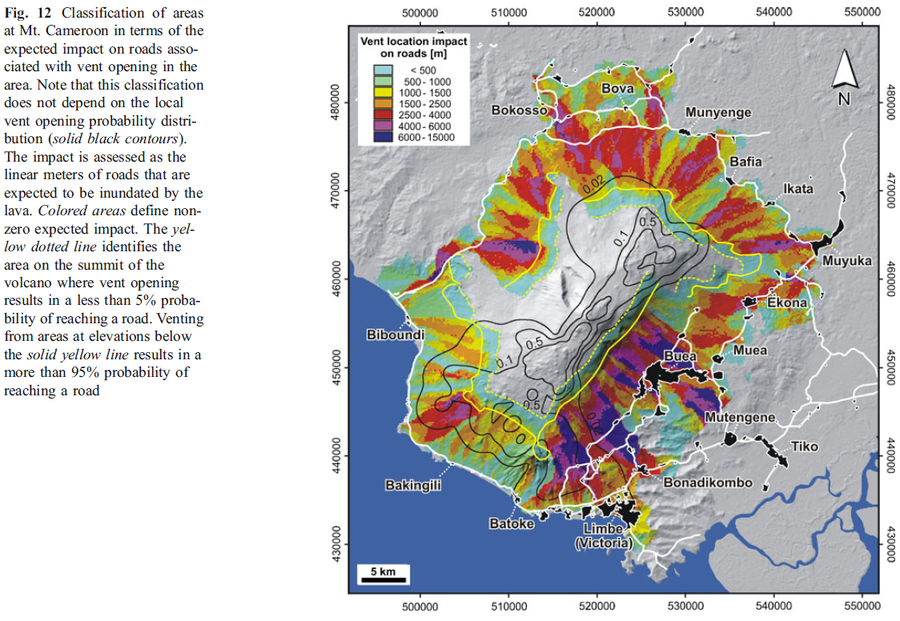
Figure in a journal article
Classification of areas at Mt. Cameroon in terms of the expected impact on roads associated with vent opening in the area
Figure 12 in: Favalli, M., Tarquini, S., Papale, P., Fornaciai, A., & Boschi, E. (2012). Lava flow hazard and risk at Mt. Cameroon volcano. Bulletin of Volcanology, 74(2), 423-439. https://doi.org/10.1007/s00445-011-0540-6
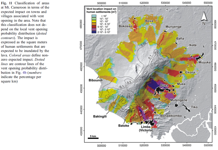
Figure in a journal article
Classification of areas at Mt. Cameroon in terms of the expected impact on towns and villages associated with vent opening in the area
Figure 11 in: Favalli, M., Tarquini, S., Papale, P., Fornaciai, A., & Boschi, E. (2012). Lava flow hazard and risk at Mt. Cameroon volcano. Bulletin of Volcanology, 74(2), 423-439. https://doi.org/10.1007/s00445-011-0540-6
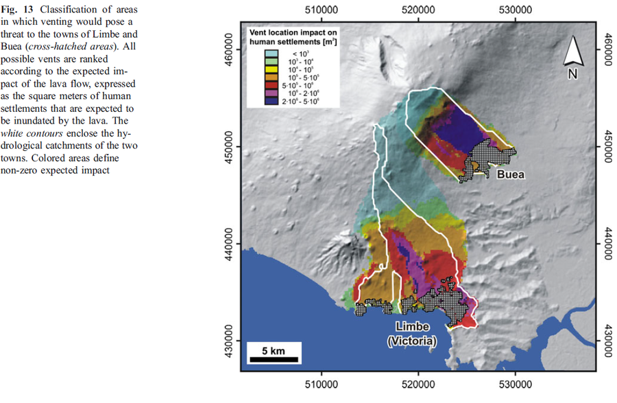
Figure in a journal article
Classification of areas in which venting would pose a threat to the towns of Limbe and Buea
Figure 13 in: Favalli, M., Tarquini, S., Papale, P., Fornaciai, A., & Boschi, E. (2012). Lava flow hazard and risk at Mt. Cameroon volcano. Bulletin of Volcanology, 74(2), 423-439. https://doi.org/10.1007/s00445-011-0540-6
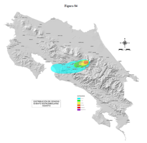
Official, Figure in hazard assessment
Distribución de Cenizas Evento Estromboliano Agosto
(Ash Distribution Strombolian Event August)
Figure 84 in: Soto, G.J. & Sjöbohm, L. (2015). Escenarios de amenaza del volcán Irazú (Costa Rica): Una aproximación preliminar. FUNDEVI, Universidad de Costa Rica, Escuela Centroamericana de Geología. 188 p. https://doi.org/10.13140/RG.2.2.22061.54240