
Advanced Search for Maps
Showing 1-10 of 508
Official, Map sheet or poster
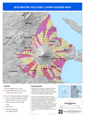
2018 Mayon Volcano Lahar Hazard Map
Philippine Institute of Volcanology and Seismology (PHIVOLCS). (2018). 2018 Mayon Volcano Lahar Hazard Map.
Official, Map sheet or poster
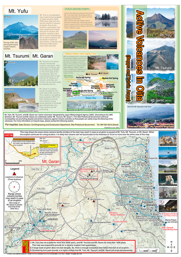
Active Volcanoes in Oita
Oita Prefectural Government. (2006). Active Volcanoes in Oita (Beppu and Yufuin Areas). Sabo Division, Civil Engineering and Construction Department, Oita Prefectural Government.
Official, Insert/poster-size map with accompanying report
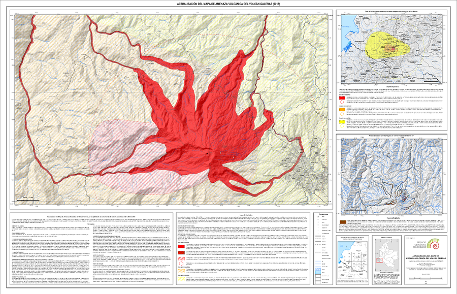
Actualización del Mapa de Amenaza Volcánica del Volcán Galeras (2015)
(Update of the Volcanic Hazard Map of the Galeras Volcano (2015))
Pocket insert in: Servicio Geológico Colombiano (SGC) Direccion de Geoamenazas. (2015). Actualización del Mapa de Amenaza Volcánica del Volcán Galeras - Colombia. En cumplimiento a la Sentencia de la Corte Constitucional T-269 de 2015.
Official, Figure in hazard assessment
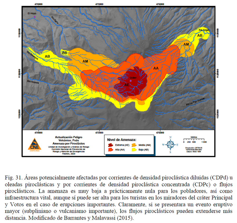
Actualización Peligro Volcánico, Poás. Amenaza por Piroclástos.
(Volcanic Danger Update, Poás. Hazard from Pyroclasts.)
Figure 31 in: Alvarado, G.E., Esquivel, L., Sánchez, B.E., & Alfaro, J.C. (2020). Actualización del Peligro Volcánico del Poás, Costa Rica. Comisión Nacional de Prevención de Riesgos y Atención de Emergencias (CNE). Febrero 2020. (Modified from: Barrantes & Malavassi 2015).
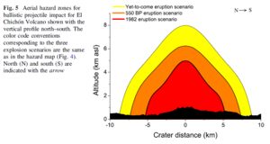
Figure in a journal article
Aerial hazard zones for ballistic projectile impact for El Chichón Volcano shown with the vertical profile north–south
Figure 5 in: Alatorre-Ibargüengoitia, M.A., Morales-Iglesias, H., Ramos-Hernández, S.G., Jon-Selvas, J., & Jiménez-Aguilar, J.M. (2016). Hazard zoning for volcanic ballistic impacts at El Chichón Volcano (Mexico). Natural Hazards, 81(3), p. 1733-1744. https://doi.org/10.1007/s11069-016-2152-0
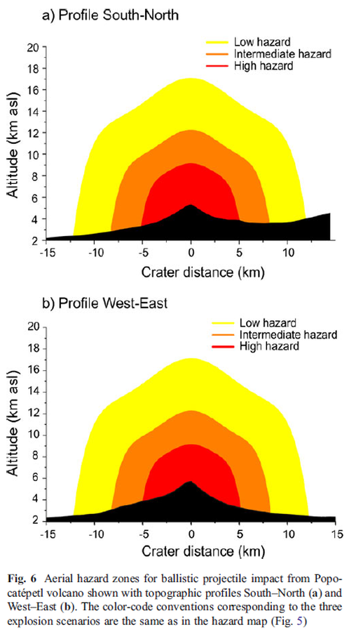
Figure in a journal article
Aerial hazard zones for ballistic projectile impact from Popocatépetl volcano shown with topographic profiles
Figure 6 in: Alatorre-Ibargüengoitia, M. A., Delgado-Granados, H., & Dingwell, D. B. (2012). Hazard map for volcanic ballistic impacts at Popocatépetl volcano (Mexico). Bulletin of Volcanology, 74(9), p. 2155-2169. https://doi.org/10.1007/s00445-012-0657-2
Official, Map sheet or poster
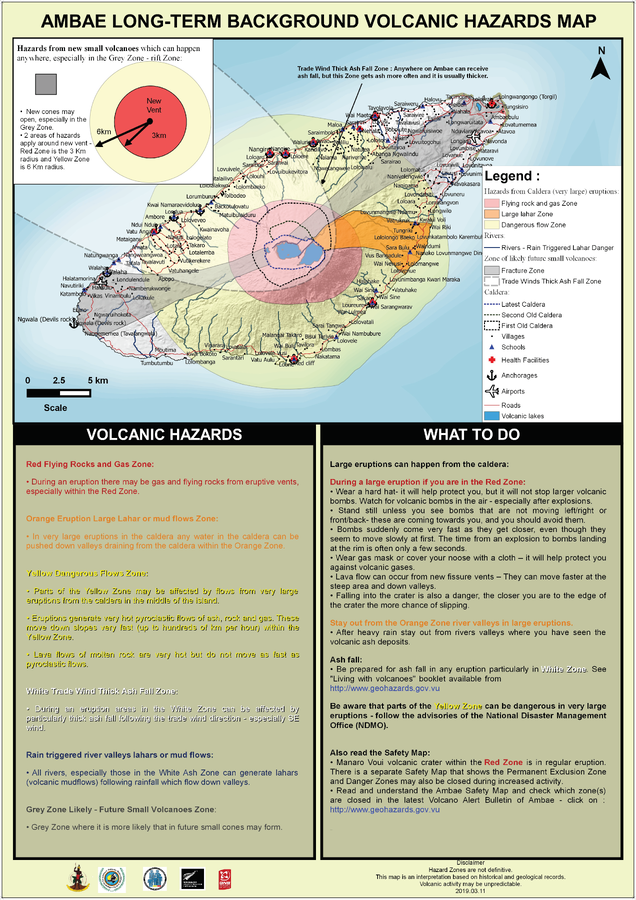
Ambae Long-Term Background Volcanic Hazards Map
Vanuatu Meteorology & Geo-Hazards Department. (2019). Ambae Long-Term Background Volcanic Hazards Map. Government of Vanuatu, Vanuatu Meteorology & Geo-Hazards Department, Vanuatu National Disaster Risk Management Office, New Zealand Foreign Affairs & Trade Aid Programme, GNS Science.
Official, Map sheet or poster
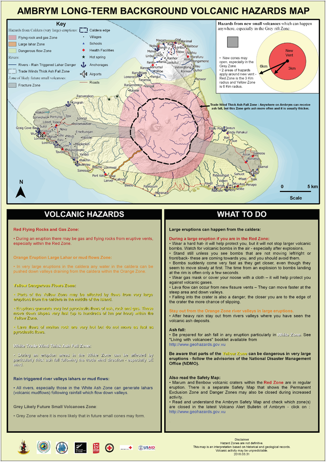
Ambrym Long-Term Background Volcanic Hazards Map
Vanuatu Meteorology & Geo-Hazards Department. (2016). Ambrym Long-Term Background Volcanic Hazards Map. Government of Vanuatu, Vanuatu Meteorology & Geo-Hazards Department, Vanuatu National Disaster Risk Management Office, New Zealand Foreign Affairs & Trade Aid Programme, GNS Science, The Vanuatu Red Cross Society, Croix Rouge Francaise, USAID.
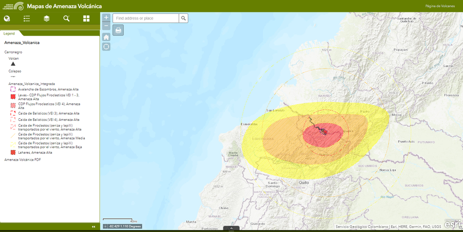
Official, Interactive web-based map
Amenaza Cerro Negro
(Cerro Negro hazards)
Servicio Geológico Colombiano (SGC). Amenaza Cerro-Negro.

Official, Interactive web-based map
Amenaza Chiles
(Chiles Hazards)
Servicio Geológico Colombiano (SGC). Amenaza Chiles.