
Advanced Search for Maps
Showing 1-10 of 36
Official, Figure in hazard assessment
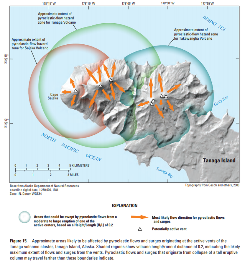
Approximate areas likely to be affected by pyroclastic flows and surges originating at the active vents of the Tanaga volcanic cluster, Tanaga Island, Alaska
Figure 15 in: Coombs, M.L., McGimsey, R.G. & Browne, B.L. (2007). Preliminary volcano-hazard assessment for the Tanaga volcanic cluster, Tanaga Island, Alaska. U.S. Geological Survey, Scientific Investigations Report 2007-5094, 41 p., 1 plate. https://doi.org/10.3133/sir20075094
Official, Figure in hazard assessment
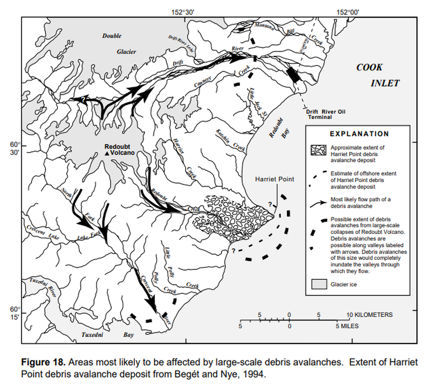
Areas most likely to be affected by large-scale debris avalanches
Figure 18 in: Waythomas, C.F., Dorava, J.M., Miller, T.P., Neal, C.A. & McGimsey, R.G. (1997). Preliminary volcano-hazard assessment for Redoubt Volcano, Alaska. U.S. Geological Survey, Open-File Report 97-857, 40 p., 1 plate. https://doi.org/10.3133/ofr97857
Official, Figure in hazard assessment
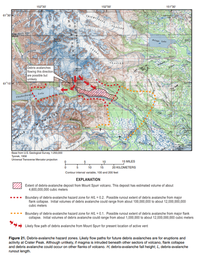
Debris-avalanche hazard zone
Figure 21 in: Waythomas, C.F. & Nye, C.J. (2002). Preliminary volcano-hazard assessment for Mount Spurr Volcano, Alaska. U.S. Geological Survey, Open-File Report 2001-482, 40 p., 1 plate. https://doi.org/10.3133/ofr01482
Official, Insert/poster-size map with accompanying report
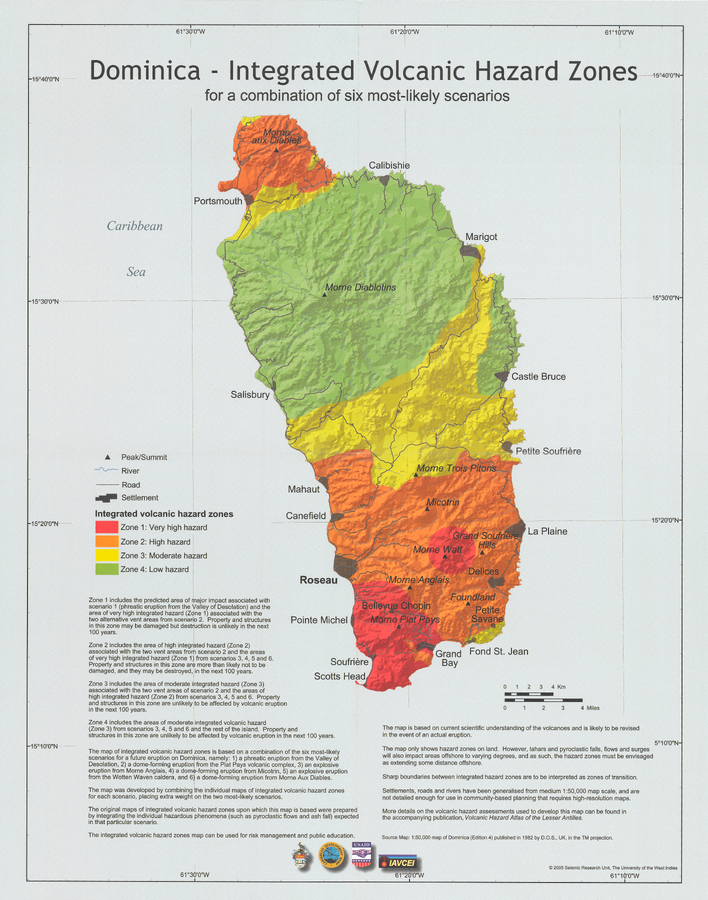
Dominica - Integrated Volcanic Hazard Zones for a combination of six most-likely scenarios
Pocket insert in: Lindsay, J.M., Smith, A.L., Roobol, M.J., & Stasiuk, M.V. (2005). Dominica. Volcanic hazard atlas of the Lesser Antilles. In: Lindsay, J.M., Shepherd, J.B., Robertson, R.E.A., & Ali, S. (Eds) Volcanic hazard atlas of the Lesser Antilles. Seismic Research Unit, The University of the West Indies, Trinidad and Tobago, W.I. p. 2-47
Official, Map sheet or poster
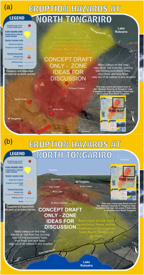
Eruption Hazards at North Tongariro
GNS Science (compiler). (2012). Te Maari Eruption Phenomena. Version 0.1, 6 August 2012. (Reprinted in: Leonard, G. S., Stewart, C., Wilson, T. M., Procter, J. N., Scott, B. J., Keys, H. J., Jolly, G.E., Wardman, J.B., Cronin. S.J. & McBride, S. K. (2014). Integrating multidisciplinary science, modelling and impact data into evolving, syn-event volcanic hazard mapping and communication: a case study from the 2012 Tongariro eruption crisis, New Zealand. Journal of Volcanology and Geothermal Research, 286, p. 208-232. https://doi.org/10.1016/j.jvolgeores.2014.08.018)
Official, Figure in hazard assessment
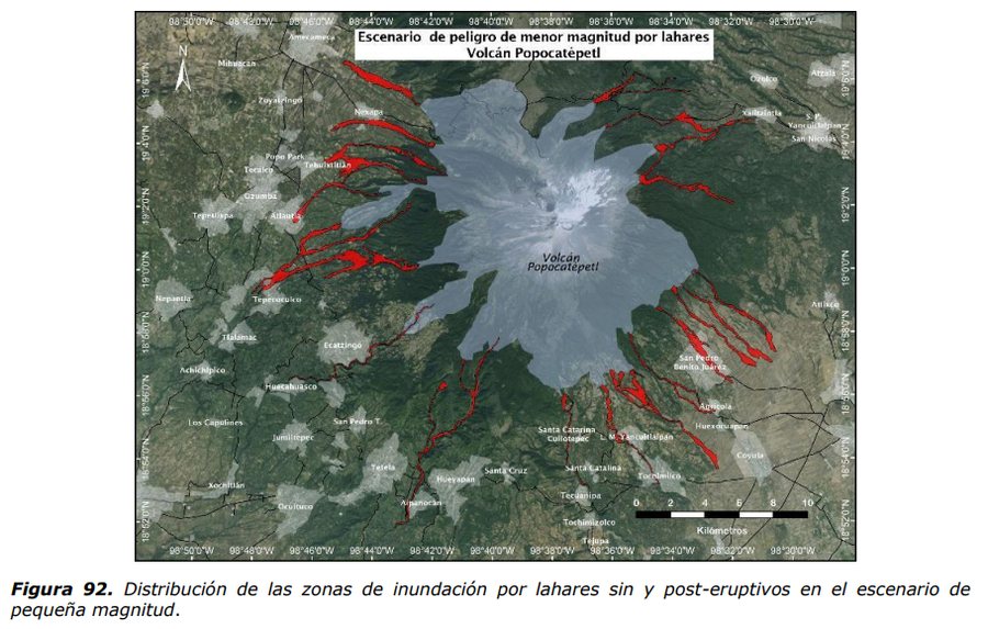
Escenario de peligro de menor magnitud por lahares Volcan Popocatépetl
(Hazard scenario of lesser magnitude due to lahars Popocatépetl Volcano)
Figure 92 in: Martin Del Pozzo, A.L, Alatorre Ibargüengoitia M., Arana Salinas L., Bonasia R., Capra Pedol L., Cassata W., Cordoba G., Cortés Ramos J., Delgado Granados H., Ferrés López M.D., Fonseca Álvarez R., García Reynoso J.A., Gisbert G., Guerrero López D.A., Jaimes Viera M., Macías Vázquez J.L., Nieto Obregon J., Nieto Torres A., Paredes Ruiz P.A., Portocarrero Martínez J., Renne P., Rodríguez Espinosa D.M., Salinas Sánchez S., Siebe Grabach C., & Tellez Ugalde E. (2017). Estudios geológicos y actualización del mapa de peligros del volcán Popocatépetl. Memoria técnica del mapa de peligros del volcán Popocatépetl. Instituto de Geofísica, Universidad Nacional Autónoma de México (UNAM).
Official, Insert/poster-size map with accompanying report
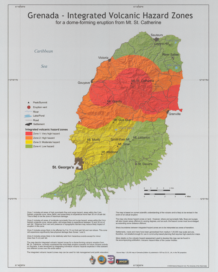
Grenada - Integrated volcanic hazard map for a dome-forming eruption from Mt. St. Catherine
Pocket Insert in: Robertson, R. (2005). Grenada. In: Lindsay, J.M., Shepherd, J.B., Robertson, R.E.A., & Ali, S. (Eds) Volcanic hazard atlas of the Lesser Antilles. Seismic Research Unit, The University of the West Indies, Trinidad and Tobago, W.I., p. 49-66
Official, Figure on website
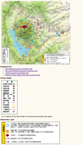
Hakone-machi volcanic disaster prevention map whole area
Hakone-machi Town. (2004). Entire volcano disaster prevention map. Hakone Volcano Disaster Prevention Map. https://www.town.hakone.kanagawa.jp/index.cfm/10,1218,46,167,html
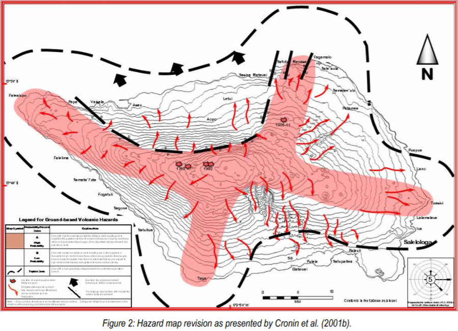
Official, Figure in hazard assessment
Hazard map revision as presented by Cronin et al. (2001b)
Figure 2 in: Cronin, S., Bonte-Grapentin, M. & Nemeth, K. (2006). Samoa technical report - Review of volcanic hazard maps for Savai'i and Upolu. Pacific Islands Applied Geoscience Commission (SOPAC) Project Report 59.
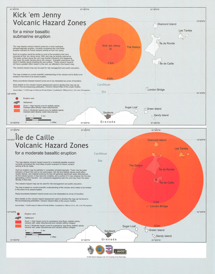
Official, Insert/poster-size map with accompanying report
Kick 'em Jenny Volcanic Hazard Zones for a minor basaltic submarine eruption & Île de Caille Volcanic Hazard Zones for a moderate basaltic eruption
Pocket insert in: Lindsay, J.M. & Shepherd, J.B. (2005). Kick’em Jenny and Ile de Caille. In: Lindsay, J.M., Shepherd, J.B., Robertson, R.E.A., & Ali, S. (Eds) Volcanic hazard atlas of the Lesser Antilles. Seismic Research Unit, The University of the West Indies, Trinidad and Tobago, W.I., p. 105-125.