
Advanced Search for Maps
Showing 621-630 of 2217
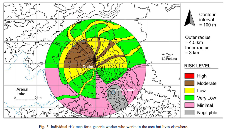
Figure in a journal article
Individual risk map for a generic worker who works in the area but lives elsewhere
Figure 5 in: Meloy, A. F. (2006). Arenal-type pyroclastic flows: a probabilistic event tree risk analysis. Journal of Volcanology and Geothermal Research, 157(1-3), 121-134. https://doi.org/10.1016/j.jvolgeores.2006.03.048
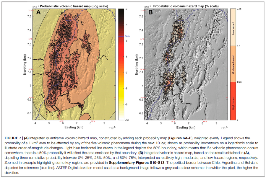
Figure in a journal article
Integrated quantitative volcanic hazard map, constructed by adding each probability map (Figures 6A–E), weighted evenly
Figure 7 in: Bertin, D., Lindsay, J.M., Cronin, S.J., de Silva, S.L., Connor, C.B., Caffe, P.J., Grosse, P., Báez, W., Bustos, E., & Constantinescu, R. (2022). Probabilistic Volcanic Hazard Assessment of the 22.5–28° S Segment of the Central Volcanic Zone of the Andes. Frontiers in Earth Science, 10. https://doi.org/10.3389/feart.2022.875439

Official, Figure in hazard assessment
Integrated volcanic hazard map for eruption Scenario 2: Effusive dome growth from Mt. St. Catherine
Page 63 in: Robertson, R. (2005). Grenada. In: Lindsay, J.M., Shepherd, J.B., Robertson, R.E.A., & Ali, S. (Eds) Volcanic hazard atlas of the Lesser Antilles. Seismic Research Unit, The University of the West Indies, Trinidad and Tobago, W.I., p. 49-66

Official, Figure in hazard assessment
Integrated volcanic hazard map for eruption Scenario 3: Explosive eruption from Mt. St. Catherine
Page 64 in: Robertson, R. (2005). Grenada. In: Lindsay, J.M., Shepherd, J.B., Robertson, R.E.A., & Ali, S. (Eds) Volcanic hazard atlas of the Lesser Antilles. Seismic Research Unit, The University of the West Indies, Trinidad and Tobago, W.I., p. 49-66
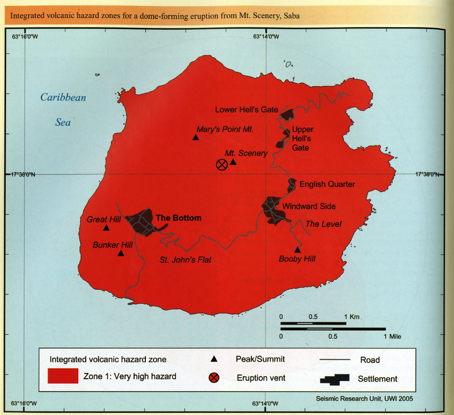
Official, Figure in hazard assessment
Integrated volcanic hazard zones for a dome-forming eruption from Mt. Scenery, Saba
Page 189 in: Smith, A.L. & Roobol, M.J. (2005). Saba. In: Lindsay, J.M., Shepherd, J.B., Robertson, R.E.A., & Ali, S. (Eds) Volcanic hazard atlas of the Lesser Antilles. Seismic Research Unit, The University of the West Indies, Trinidad and Tobago, W.I., p. 181-191.
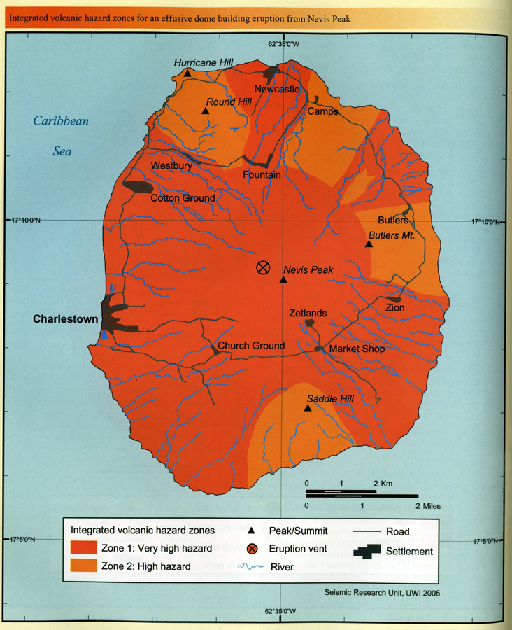
Official, Figure in hazard assessment
Integrated volcanic hazard zones for an effusive dome building eruption from Nevis Peak
Page 176 in: Simpson, K. (2005). Nevis. In: Lindsay, J.M., Shepherd, J.B., Robertson, R.E.A., & Ali, S. (Eds) Volcanic hazard atlas of the Lesser Antilles. Seismic Research Unit, The University of the West Indies, Trinidad and Tobago, W.I., p. 170-178.
Official, Figure in hazard assessment
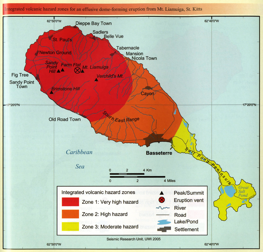
Integrated volcanic hazard zones for an effusive dome-forming eruption from Mt. Liamuiga, St. Kitts
Page 214 in: Robertson, R.E.A. (2005). St. Kitts. In: Lindsay, J.M., Shepherd, J.B., Robertson, R.E.A., & Ali, S. (Eds) Volcanic hazard atlas of the Lesser Antilles. Seismic Research Unit, The University of the West Indies, Trinidad and Tobago, W.I., p. 205-217.
Official, Figure in hazard assessment
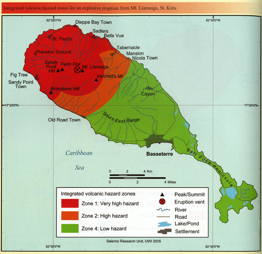
Integrated volcanic hazard zones for an explosive eruption from Mt. Liamuiga, St. Kitts
Page 215 in: Robertson, R.E.A. (2005). St. Kitts. In: Lindsay, J.M., Shepherd, J.B., Robertson, R.E.A., & Ali, S. (Eds) Volcanic hazard atlas of the Lesser Antilles. Seismic Research Unit, The University of the West Indies, Trinidad and Tobago, W.I., p. 205-217.
Official, Figure in hazard assessment
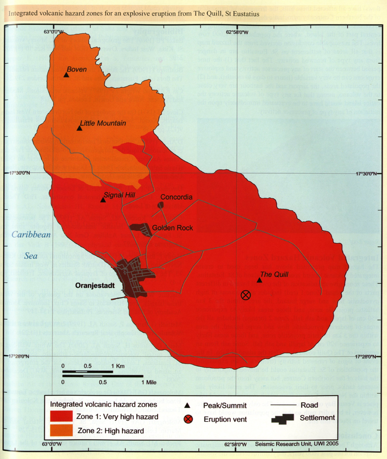
Integrated volcanic hazard zones for an explosive eruption from The Quill, St Eustatius
Page 200 in: Smith, A.L. & Roobol, M.J. (2005). St. Eustatius. In: Lindsay, J.M., Shepherd, J.B., Robertson, R.E.A., & Ali, S. (Eds) Volcanic hazard atlas of the Lesser Antilles. Seismic Research Unit, The University of the West Indies, Trinidad and Tobago, W.I., p. 193-203
Official, Figure in hazard assessment
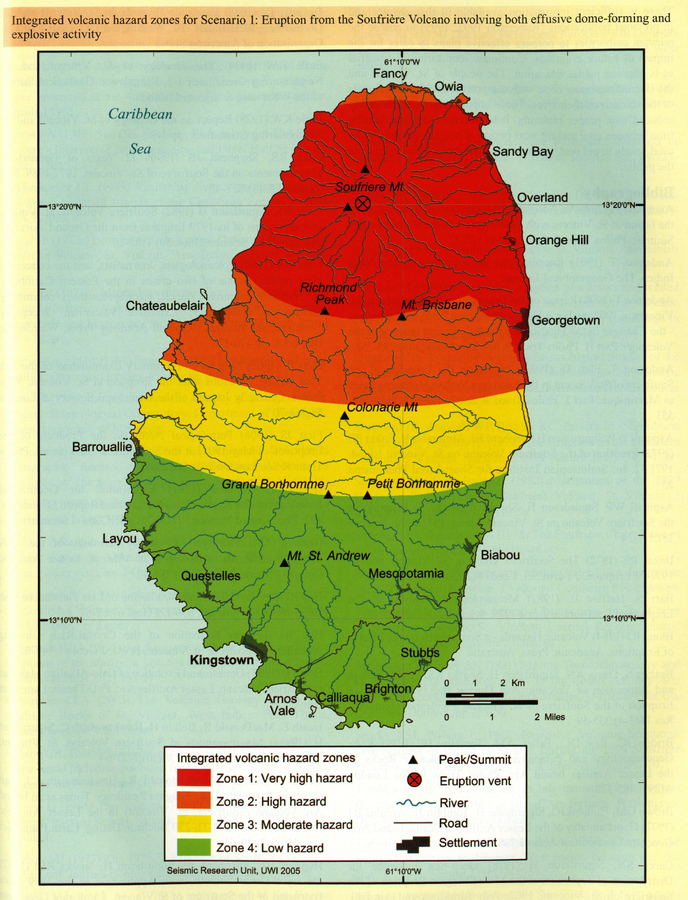
Integrated volcanic hazard zones for Scenario 1: Eruption from the Soufrière Volcano involving both effusive dome-forming and explosive activity
Page 258 in: Robertson, R. (2005). St. Vincent. In: Lindsay, J.M., Shepherd, J.B., Robertson, R.E.A., & Ali, S. (Eds) Volcanic hazard atlas of the Lesser Antilles. Seismic Research Unit, The University of the West Indies, Trinidad and Tobago, W.I., p. 241-261