
Advanced Search for Maps
Showing 631-640 of 2217
Official, Figure in hazard assessment
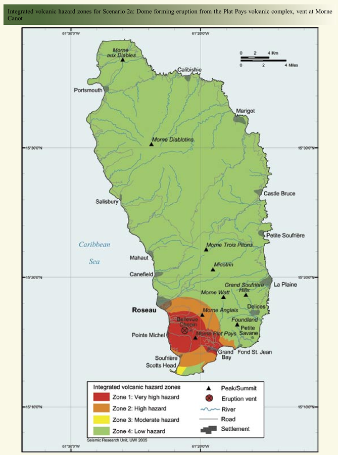
Integrated volcanic hazard zones for Scenario 2a: Dome forming eruption from the Plat Pays volcanic complex, vent at Morne Canot
Page 22 in: Lindsay, J.M., Smith, A.L., Roobol, M.J., & Stasiuk, M.V. (2005). Dominica. Volcanic hazard atlas of the Lesser Antilles. In: Lindsay, J.M., Shepherd, J.B., Robertson, R.E.A., & Ali, S. (Eds) Volcanic hazard atlas of the Lesser Antilles. Seismic Research Unit, The University of the West Indies, Trinidad and Tobago, W.I. p. 2-47
Official, Figure in hazard assessment
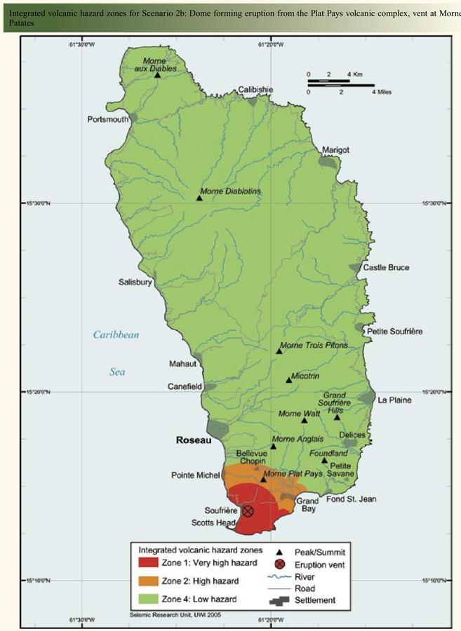
Integrated volcanic hazard zones for Scenario 2b: Dome forming eruption from the Plat Pays volcanic complex, vent at Morne Patates
Page 25 in: Lindsay, J.M., Smith, A.L., Roobol, M.J., & Stasiuk, M.V. (2005). Dominica. Volcanic hazard atlas of the Lesser Antilles. In: Lindsay, J.M., Shepherd, J.B., Robertson, R.E.A., & Ali, S. (Eds) Volcanic hazard atlas of the Lesser Antilles. Seismic Research Unit, The University of the West Indies, Trinidad and Tobago, W.I. p. 2-47
Official, Figure in hazard assessment
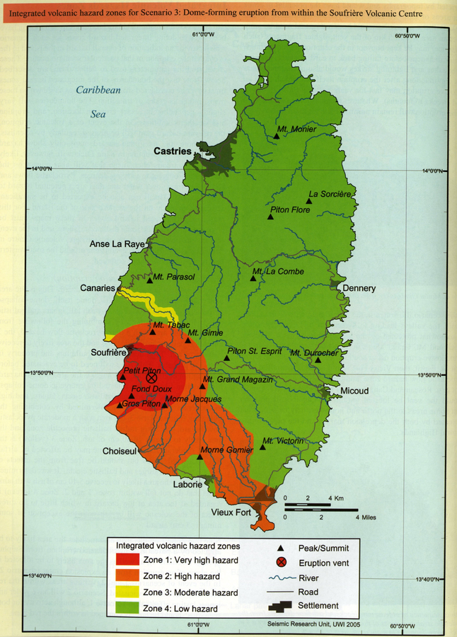
Integrated volcanic hazard zones for Scenario 3: Dome-forming eruption from within the Soufrière Volcanic Centre
Page 235 in: Lindsay, J.M. (2005). Saint Lucia. In: Lindsay, J.M., Shepherd, J.B., Robertson, R.E.A., & Ali, S. (Eds) Volcanic hazard atlas of the Lesser Antilles. Seismic Research Unit, The University of the West Indies, Trinidad and Tobago, W.I., p. 219-239.
Official, Figure in hazard assessment
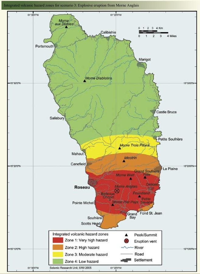
Integrated volcanic hazard zones for scenario 3: Explosive eruption from Morne Anglais
Page 28 in: Lindsay, J.M., Smith, A.L., Roobol, M.J., & Stasiuk, M.V. (2005). Dominica. Volcanic hazard atlas of the Lesser Antilles. In: Lindsay, J.M., Shepherd, J.B., Robertson, R.E.A., & Ali, S. (Eds) Volcanic hazard atlas of the Lesser Antilles. Seismic Research Unit, The University of the West Indies, Trinidad and Tobago, W.I. p. 2-47
Official, Figure in hazard assessment
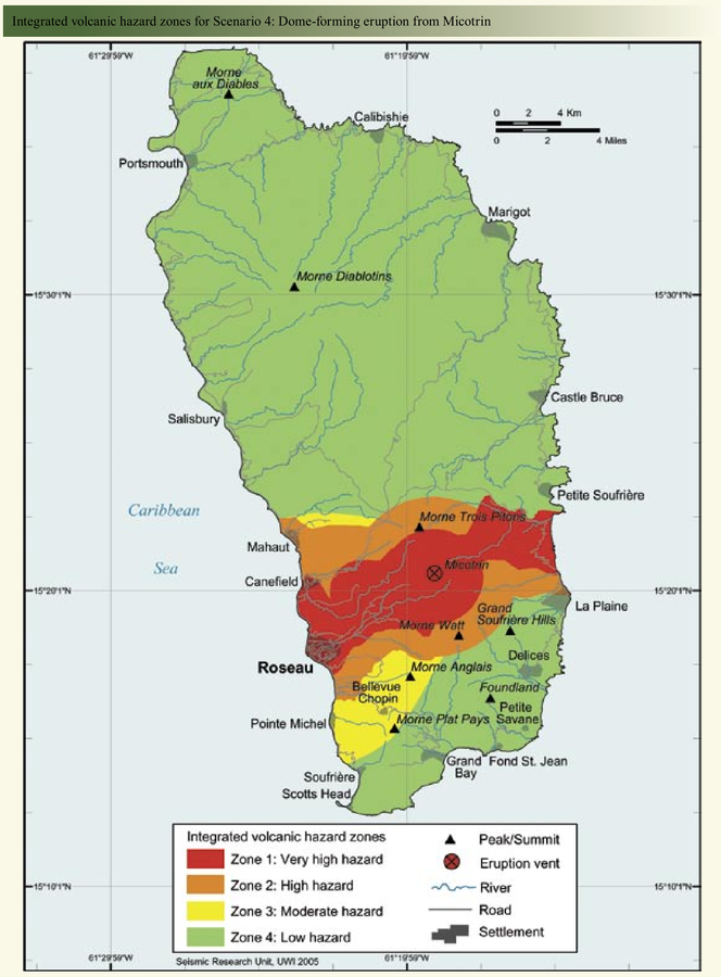
Integrated volcanic hazard zones for Scenario 4: Dome-forming eruption from Micotrin
Page 32 in: Lindsay, J.M., Smith, A.L., Roobol, M.J., & Stasiuk, M.V. (2005). Dominica. Volcanic hazard atlas of the Lesser Antilles. In: Lindsay, J.M., Shepherd, J.B., Robertson, R.E.A., & Ali, S. (Eds) Volcanic hazard atlas of the Lesser Antilles. Seismic Research Unit, The University of the West Indies, Trinidad and Tobago, W.I. p. 2-47
Official, Figure in hazard assessment
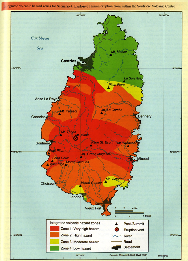
Integrated volcanic hazard zones for Scenario 4: Explosive Plinian eruption from within the Soufrière Volcanic Centre
Page 236 in: Lindsay, J.M. (2005). Saint Lucia. In: Lindsay, J.M., Shepherd, J.B., Robertson, R.E.A., & Ali, S. (Eds) Volcanic hazard atlas of the Lesser Antilles. Seismic Research Unit, The University of the West Indies, Trinidad and Tobago, W.I., p. 219-239.
Official, Figure in hazard assessment
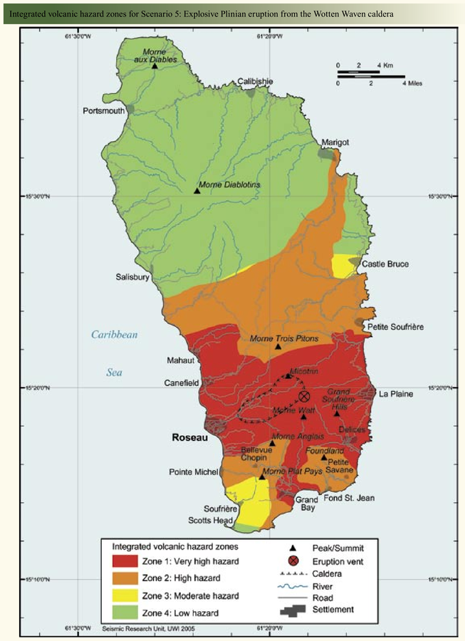
Integrated volcanic hazard zones for Scenario 5: Explosive Plinian eruption from the Wotten Waven caldera
Page 35 in: Lindsay, J.M., Smith, A.L., Roobol, M.J., & Stasiuk, M.V. (2005). Dominica. Volcanic hazard atlas of the Lesser Antilles. In: Lindsay, J.M., Shepherd, J.B., Robertson, R.E.A., & Ali, S. (Eds) Volcanic hazard atlas of the Lesser Antilles. Seismic Research Unit, The University of the West Indies, Trinidad and Tobago, W.I. p. 2-47
Official, Figure in hazard assessment
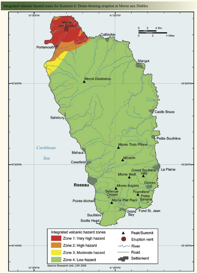
Integrated volcanic hazard zones for Scenario 6: Dome-forming eruption at Morne aux Diables
Page 39 in: Lindsay, J.M., Smith, A.L., Roobol, M.J., & Stasiuk, M.V. (2005). Dominica. Volcanic hazard atlas of the Lesser Antilles. In: Lindsay, J.M., Shepherd, J.B., Robertson, R.E.A., & Ali, S. (Eds) Volcanic hazard atlas of the Lesser Antilles. Seismic Research Unit, The University of the West Indies, Trinidad and Tobago, W.I. p. 2-47
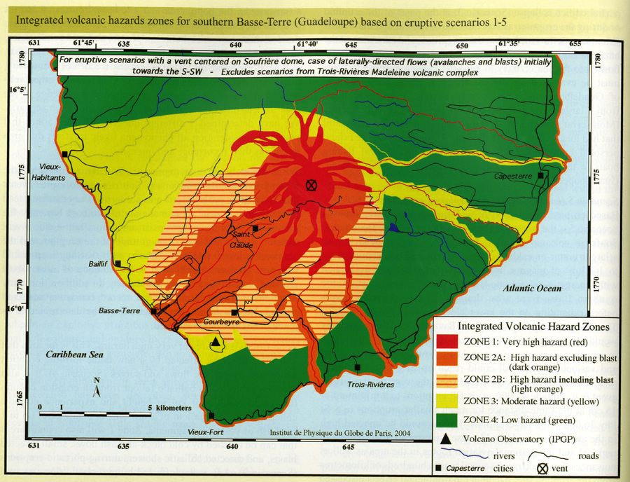
Official, Figure in hazard assessment
Integrated volcanic hazards zones for southern Basse-Terre (Guadeloupe) based on eruptive scenarios 1-5
Page 98 in: Komorowski, J.-C., Boudon, G., Michel-Semet, Beauducel, F., Anténor-Habazac, C., Bazin, S., & Hammouya, G. (2005). Guadeloupe. In: Lindsay, J.M., Shepherd, J.B., Robertson, R.E.A., & Ali, S. (Eds) Volcanic hazard atlas of the Lesser Antilles. Seismic Research Unit, The University of the West Indies, Trinidad and Tobago, W.I., p. 68-106.
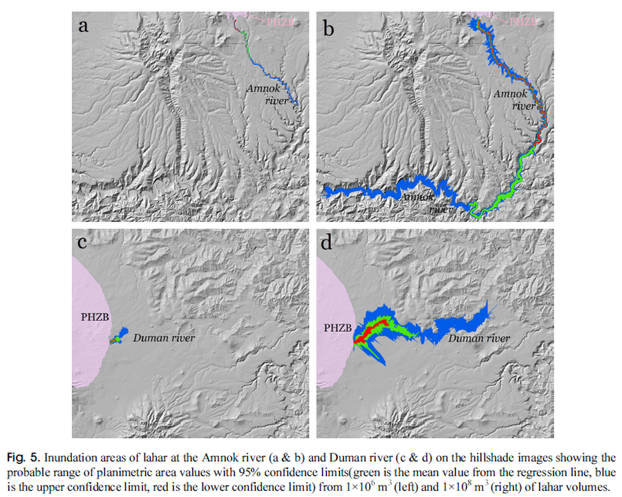
Figure in a journal article
Inundation areas of lahar at the Amnok river and Duman river
Figure 5 in: Yun, S. H. & Chang, C. (2017). Prediction of Lahar Flow Inundation Areas Using LAHARZ_py Program: Application for the Mt. Baekdu Volcano. Economic and Environmental Geology, 50(4), 277-286. https://doi.org/10.9719/EEG.2017.50.4.277