
Advanced Search for Maps
Showing 11-20 of 27
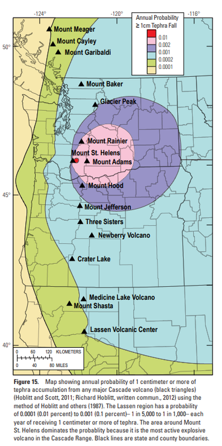
Official, Figure in hazard assessment
Map showing annual probability of 1 centimeter or more of tephra accumulation from any major Cascade volcano
Figure 15 in: Clynne, M. A., Robinson, J. E., Nathenson, M. & Muffler, L. P. (2012). Volcano hazards assessment for the Lassen region, northern California. U.S. Geological Survey, Scientific Investigations Report 2012-5176-A, 47 p., 1 plate. https://doi.org/10.3133/sir20125176A
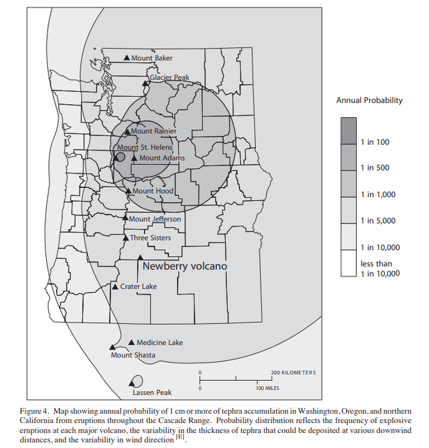
Official, Figure in hazard assessment
Map showing annual probability of 1 cm or more of tephra accumulation in Washington, Oregon, and northern California from eruptions throughout the Cascade Range.
Figure 4 in: Sherrod, D.R., Mastin, L.G., Scott, W.E. & Schilling, S.P. (1997). Volcano hazards at Newberry Volcano, Oregon. U.S. Geological Survey, Open-File Report 97-513, 14 p. https://doi.org/10.3133/ofr97513
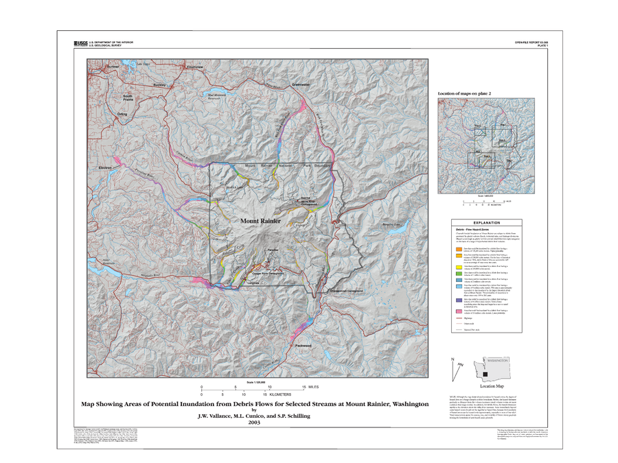
Official, Insert/poster-size map with accompanying report
Map Showing Areas of Potential Inundation from Debris Flows for Selected Streams at Mount Rainier, Washington
Plate 1 in: Vallance, J.W., Cunico, M.L. & Schilling, S.P. (2003). Debris-flow hazards caused by hydrologic events at Mount Rainier, Washington. U.S. Geological Survey, Open-File Report 03-368, 4 p., 2 plates. https://doi.org/10.3133/ofr03368
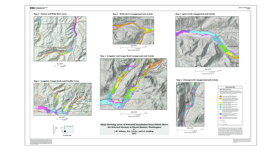
Official, Insert/poster-size map with accompanying report
Map Showing Areas of Potential Inundation from Debris Flows for Selected Streams at Mount Rainier, Washington
Plate 2 in: Vallance, J.W., Cunico, M.L. & Schilling, S.P. (2003). Debris-flow hazards caused by hydrologic events at Mount Rainier, Washington. U.S. Geological Survey, Open-File Report 03-368, 4 p., 2 plates. https://doi.org/10.3133/ofr03368
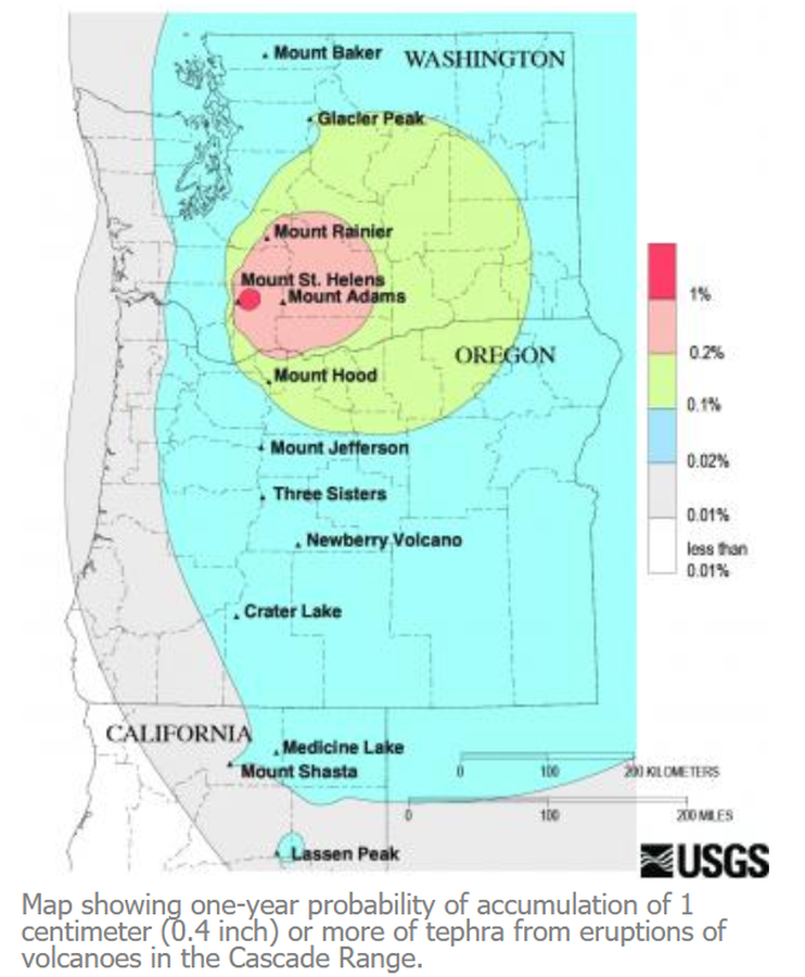
Official, Figure on website
Map showing one-year probability of accumulation of 1 centimeter (0.4 inch) or more of tephra from eruptions of volcanoes in the Cascade Range.
Nathensen, M. (2013). Map showing one-year probability of accumulation of 1 centimeter (0.4 inch) or more of tephra from eruptions of volcanoes in the Cascade Range. U.S. Geological Survey. Mount Bachelor Hazards. https://www.usgs.gov/volcanoes/mount-bachelor/hazards
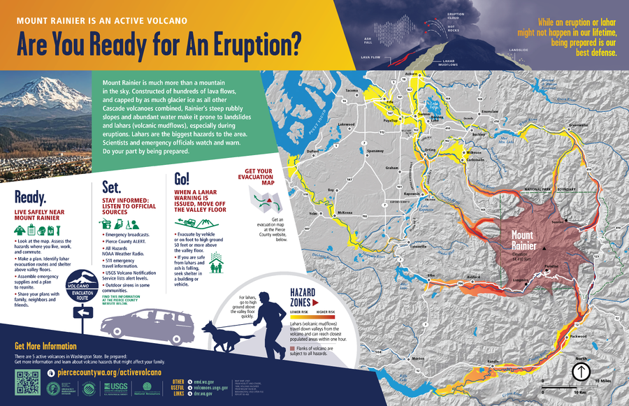
Official, Sign or billboard
Mount Rainier is An Active Volcano, Are You Ready for An Eruption?
Washington Department of Natural Resources. (2014). Mount Rainier is An Active Volcano, Are You Ready for An Eruption? (Simplified from: Hoblitt et al. 1998)

Official, Map sheet or poster
Potential Hazards From Future Eruptions of Mount Rainer, Washington.
Crandell, D.R. (1973). Map showing potential hazards from future eruptions of Mount Rainier, Washington. U.S. Geological Survey, I-Map 836. https://doi.org/10.3133/i836
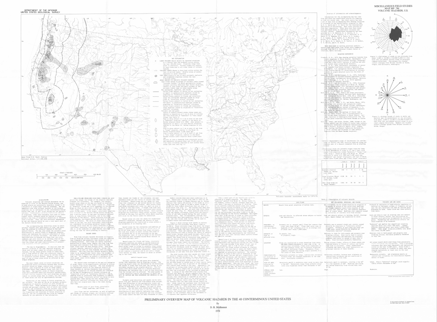
Official, Map sheet or poster
Preliminary Overview Map of Volcanic Hazards in the 48 Coterminous United States
Mullineaux, D.R. (1978). Preliminary overview map of volcanic hazards in the 48 conterminous United States. U.S. Geological Survey, Miscellaneous Field Studies Map 786. https://doi.org/10.3133/mf786
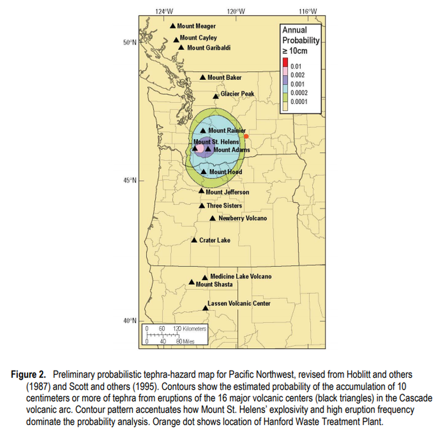
Official, Figure in hazard assessment
Preliminary probabilistic tephra-hazard map for Pacific Northwest
Figure 2 in: Hoblitt, R.P., & Scott, W.E. (2011). Estimate of tephra accumulation probabilities for the U.S. Department of Energy's Hanford Site, Washington. U.S. Geological Survey, Open-File Report 2011-1064, 15 p. https://doi.org/10.3133/ofr20111064
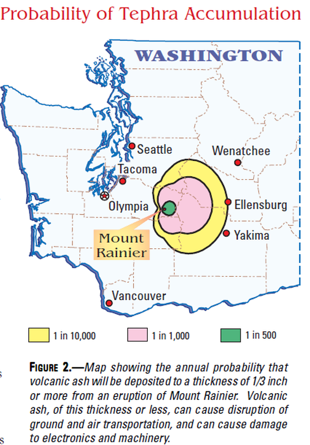
Official, Map in a booklet, long fact-sheet, or handbook
Probability of Tephra Accumulation
Figure 2 in: Driedger, C.L. & Scott, K.M. (2002). Mount Rainier: learning to live with volcanic risk. U.S. Geological Survey, Fact Sheet 034-02, 4 p. https://doi.org/10.3133/fs03402