
Advanced Search for Maps
Showing 21-30 of 31
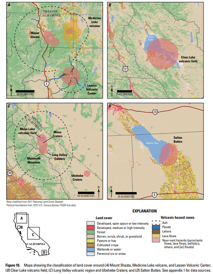
Official, Figure in hazard assessment
Maps showing the classification of land cover around (A) Mount Shasta, Medicine Lake volcano, and Lassen Volcanic Center; (B) Clear Lake volcanic field; (C ) Long Valley volcanic region and Ubehebe Craters; and (D) Salton Buttes
Figure 10 in: Mangan, M., Ball, J., Wood, N., Jones, J.L., Peters, J., Abdollahian, N., Dinitz, L., Blankenheim, S., Fenton, J., & Pridmore, C. (2019). California’s exposure to volcanic hazards. U.S. Geological Survey Scientific Investigations Report 2018–5159, v. 1.1, 49 p. https://doi.org/10.3133/sir20185159

Official, Map in a booklet, long fact-sheet, or handbook
Mudflow Hazard Zones Map
Page 18 in: Crandell, D.R. & Nichols, D.R. (1989). Volcanic hazards at Mount Shasta, California. U.S. Geological Survey, General Information Product, 22 p. https://doi.org/10.3133/70039409
Official, Insert/poster-size map with accompanying report
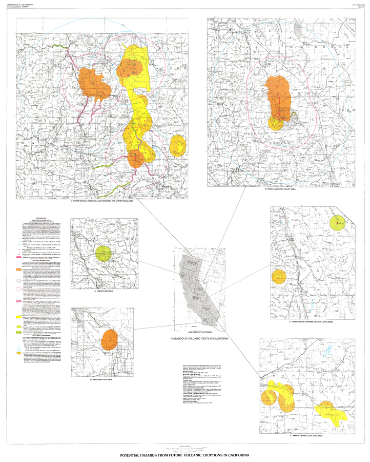
Potential Hazards from future volcanic eruptions in California
Plate 1 in: Miller, C.D. (1989). Potential hazards from future volcanic eruptions in California. U.S. Geological Survey, Bulletin 1847, 17 p., 2 tables, 1 plate, scale 1:500,000.
Official, Map sheet or poster
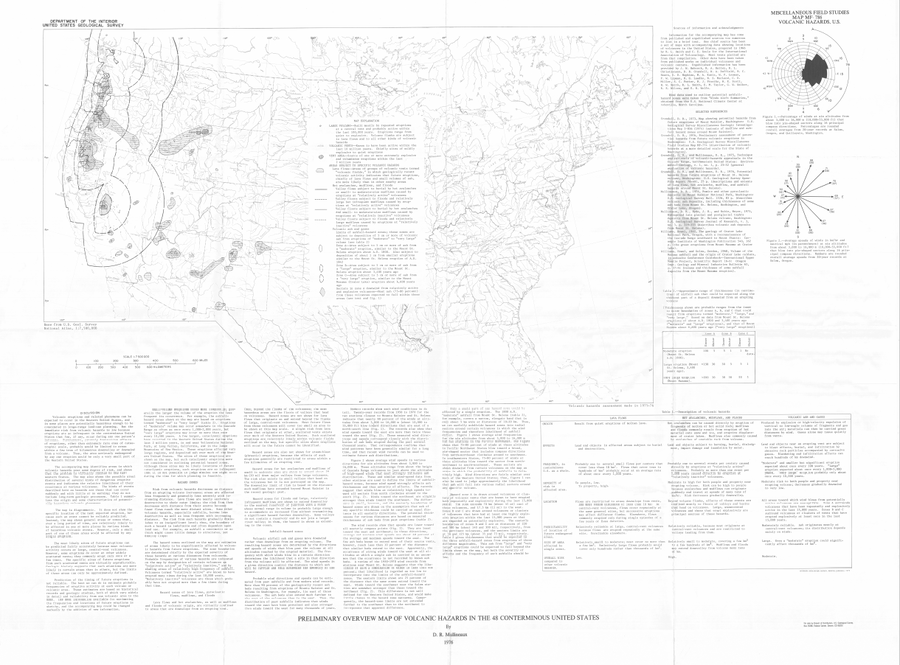
Preliminary Overview Map of Volcanic Hazards in the 48 Coterminous United States
Mullineaux, D.R. (1978). Preliminary overview map of volcanic hazards in the 48 conterminous United States. U.S. Geological Survey, Miscellaneous Field Studies Map 786. https://doi.org/10.3133/mf786
Official, Figure in hazard assessment
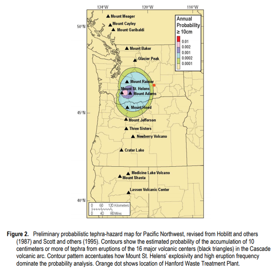
Preliminary probabilistic tephra-hazard map for Pacific Northwest
Figure 2 in: Hoblitt, R.P., & Scott, W.E. (2011). Estimate of tephra accumulation probabilities for the U.S. Department of Energy's Hanford Site, Washington. U.S. Geological Survey, Open-File Report 2011-1064, 15 p. https://doi.org/10.3133/ofr20111064

Official, Map in a booklet, long fact-sheet, or handbook
Pyroclastic Flow and Lateral Blast Hazard Map
Page 15 in: Crandell, D.R. & Nichols, D.R. (1989). Volcanic hazards at Mount Shasta, California. U.S. Geological Survey, General Information Product, 22 p. https://doi.org/10.3133/70039409
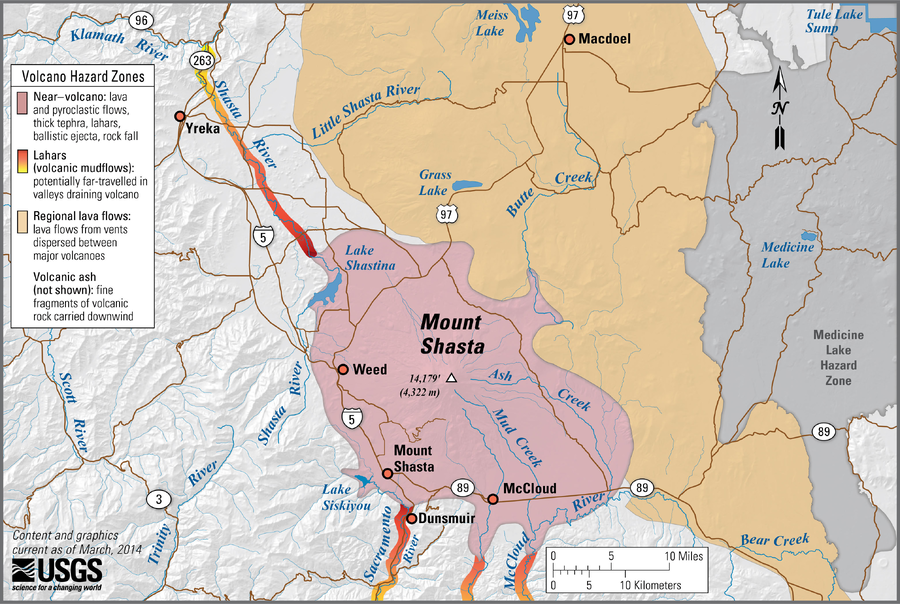
Official, Figure on website
Simplified volcano hazards map of Mount Shasta, California
Miller, C. D., Driedger, C.L., Scott, W.E., Iverson, R.M., Ramsey, D.W., & Faust, L.M. (2014). Simplified volcano hazards map of Mount Shasta, California. U.S. Geological Survey. Mount Shasta, CA Simplified Hazards Map. https://www.usgs.gov/media/images/mount-shasta-ca-simplified-hazards-map (Modified from: U.S. Geological Survey, Bulletin 1503)

Official, Map in a booklet, long fact-sheet, or handbook
Volcanic-Ash Hazard Area Map
Page 14 in: Crandell, D.R. & Nichols, D.R. (1989). Volcanic hazards at Mount Shasta, California. U.S. Geological Survey, General Information Product, 22 p. https://doi.org/10.3133/70039409
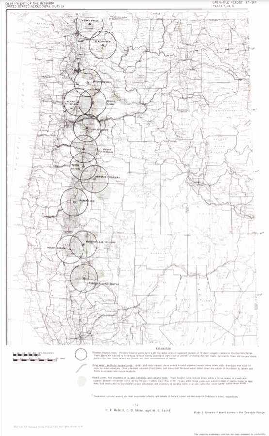
Official, Insert/poster-size map with accompanying report
Volcanic-hazard zones in the Cascades Range
Plate 1 in: Hoblitt, R. P., Miller, C. D., & Scott, W. E. (1987). Volcanic hazards with regard to siting nuclear-power plants in the Pacific Northwest. U.S. Geological Survey, Open-File Report 87-297. https://doi.org/10.3133/ofr87297
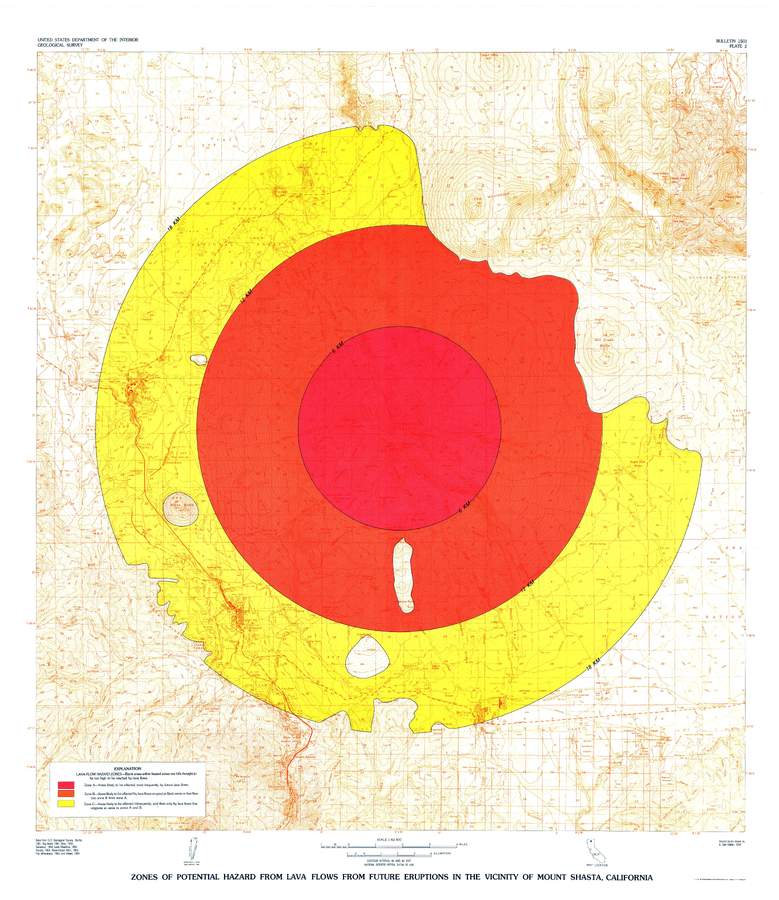
Official, Insert/poster-size map with accompanying report
Zones of Potential Hazard from Lava Flows from Future Eruptions in the Vicinity of Mount Shasta, California
Plate 2 in: Miller, C.D. (1980). Potential hazards from future eruptions in the vicinity of Mount Shasta Volcano, Northern California. U.S. Geological Survey, Bulletin 1503, 43 p., 3 plates. https://doi.org/10.3133/b1503