
Advanced Search for Maps
Showing 31-40 of 180
Official, Figure on website
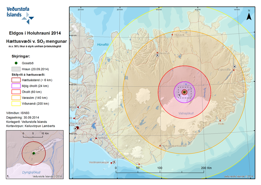
Eldgos í Holuhrauni 2014 Hættusvæði v. SO2 Mengunar m.v. 50% líkur á styrk umfram þröskuldsgildi
(Volcanic Eruption at Holuhraun 2014 Hazardous Area SO2 pollution 50% likelihood of concentration exceeding a threshold value)
Iceland Meteorological Office (IMO). (2014). Eldgos í Holuhrauni 2014 Hættusvæði v. SO2 Mengunar [Volcanic Eruption at Holuhraun 2014 Hazardous Area SO2 pollution]. (Reprinted in: Barsotti, S. (2015). Hazard Zoning: Probabilistic hazard maps of SO2 ground concentration for Holuhraun eruption. https://en.vedur.is/pollution-and-radiation/volcanic-gas/hazard-zoning/)
Official, Figure on website
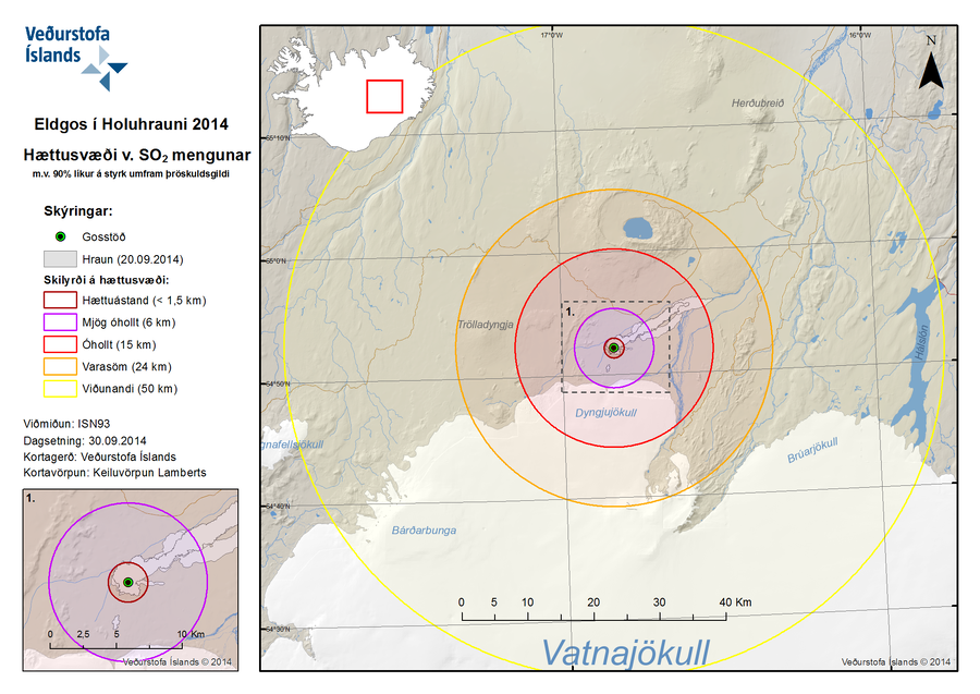
Eldgos í Holuhrauni 2014 Hættusvæði v. SO2 Mengunar m.v. 90% líkur á styrk umfram þröskuldsgildi
(Volcanic Eruption at Holuhraun 2014 Hazardous Area SO2 pollution 90% likelihood of concentration exceeding a threshold value)
Iceland Meteorological Office (IMO). (2014). Eldgos í Holuhrauni 2014 Hættusvæði v. SO2 Mengunar [Volcanic Eruption at Holuhraun 2014 Hazardous Area SO2 pollution]. (Reprinted in: Barsotti, S. (2015). Hazard Zoning: Probabilistic hazard maps of SO2 ground concentration for Holuhraun eruption. https://en.vedur.is/pollution-and-radiation/volcanic-gas/hazard-zoning/)
Official, Figure on website
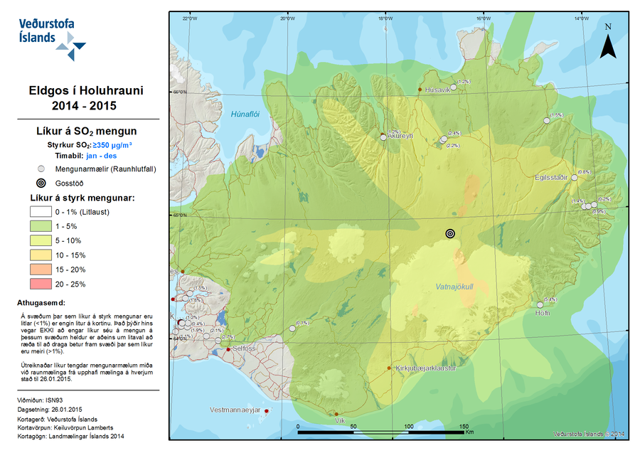
Eldgos í Holuhrauni 2014-2015 Líkur á SO2 Mengun
(Volcanic Eruption at Holuhraun 2014-2015 Probability of SO2 Contamination)
Iceland Meteorological Office (IMO). (2015). Eldgos í Holuhrauni 2014-2015 Líkur á SO2 Mengun [Volcanic Eruption at Holuhraun 2014-2015 Probability of SO2 Contamination]. (Reprinted in: Barsotti, S. (2015). Hazard Zoning: Probabilistic hazard maps of SO2 ground concentration for Holuhraun eruption. https://en.vedur.is/pollution-and-radiation/volcanic-gas/hazard-zoning/)
Official, Figure on website
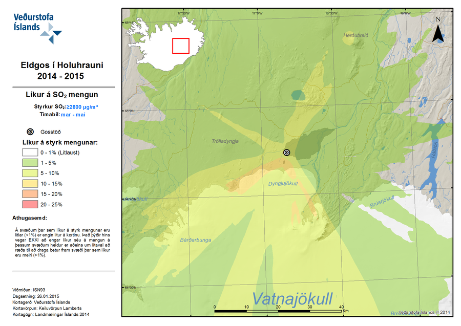
Eldgos í Holuhrauni 2014-2015 Líkur á SO2 Mengun
(Volcanic Eruption at Holuhraun 2014-2015 Probability of SO2 Contamination)
Iceland Meteorological Office (IMO). (2015). Eldgos í Holuhrauni 2014-2015 Líkur á SO2 Mengun [Volcanic Eruption at Holuhraun 2014-2015 Probability of SO2 Contamination]. (Reprinted in: Barsotti, S. (2015). Hazard Zoning: Probabilistic hazard maps of SO2 ground concentration for Holuhraun eruption. https://en.vedur.is/pollution-and-radiation/volcanic-gas/hazard-zoning/)

Figure in a journal article
Evolution of the lava flow hazard maps within the Enclos
Figure 7 in: Chevrel, M. O., Favalli, M., Villeneuve, N., Harris, A. J., Fornaciai, A., Richter, N., Derrien, A., Di Muro, A., & Peltier, A. (2021). Lava flow hazard map of Piton de la Fournaise volcano. Natural Hazards and Earth System Sciences, 21(8), 2355-2377. https://doi.org/10.5194/nhess-21-2355-2021, 2021
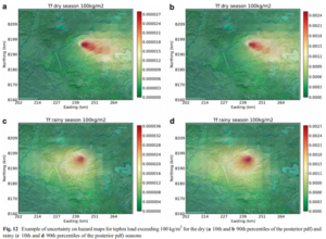
Figure in a journal article
Example of uncertainty on hazard maps for tephra load exceeding 100 kg/m² for the dry (10th and 90th percentiles of the posterior pdf) and rainy (10th and 90th percentiles of the posterior pdf) seasons
Figure 12 in: Sandri, L., Thouret, J. C., Constantinescu, R., Biass, S., & Tonini, R. (2014). Long-term multi-hazard assessment for El Misti volcano (Peru). Bulletin of volcanology, 76(2), 771. https://doi.org/10.1007/s00445-013-0771-9
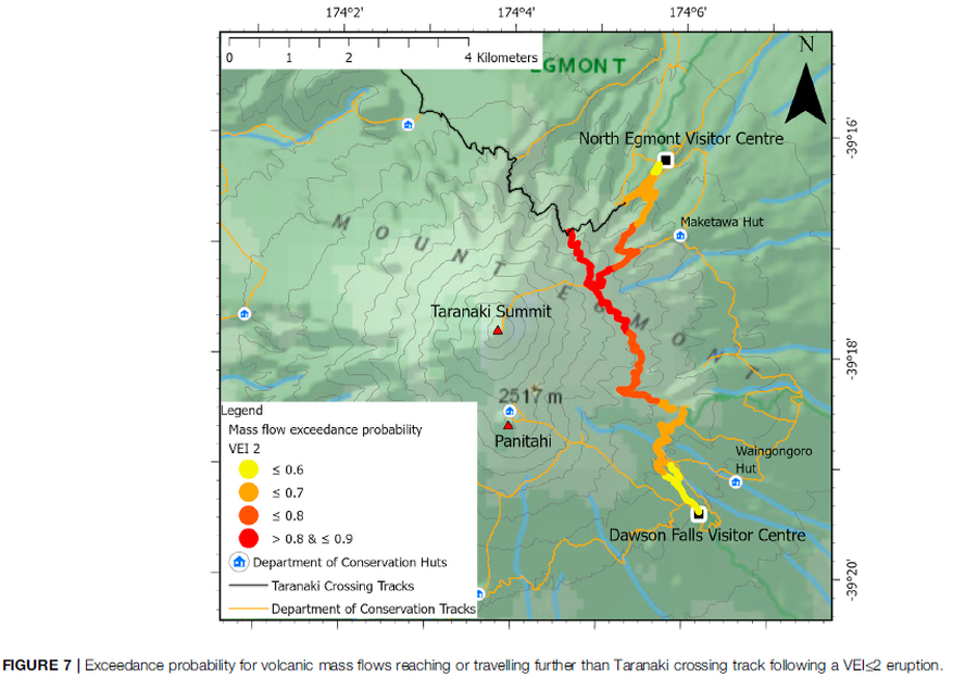
Figure in a journal article
Exceedance probability for volcanic mass flows reaching or travelling further than Taranaki crossing track following a VEI≤2 eruption
Figure 7 in: Mead, S., Procter, J., Bebbington, M., & Rodriguez-Gomez, C. (2022). Probabilistic Volcanic Hazard Assessment for National Park Infrastructure Proximal to Taranaki Volcano (New Zealand). Frontiers in Earth Science, 435. https://doi.org/10.3389/feart.2022.832531
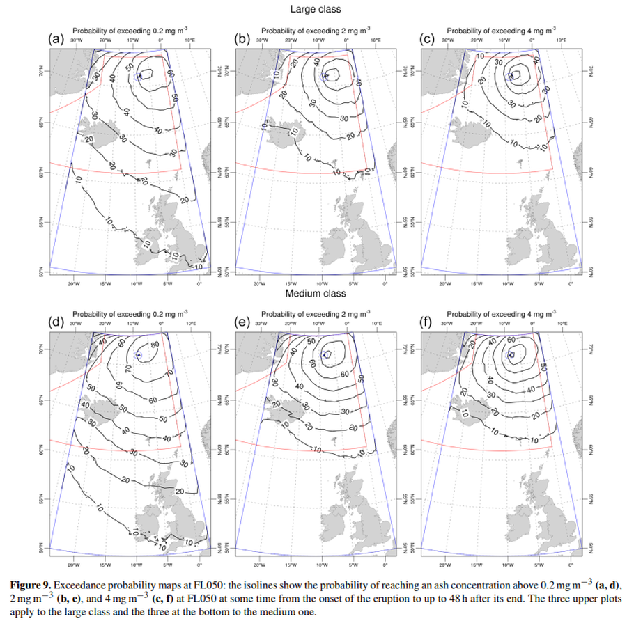
Official, Figure in a journal article
Exceedance probability maps at FL050
Figure 9 in: Titos, M., Martínez Montesinos, B., Barsotti, S., Sandri, L., Folch, A., Mingari, L., Macedonio, G. & Costa, A. (2022). Long-term hazard assessment of explosive eruptions at Jan Mayen (Norway) and implications for air traffic in the North Atlantic. Natural Hazards and Earth System Sciences, 22(1), 139-163. https://doi.org/10.5194/nhess-22-139-2022
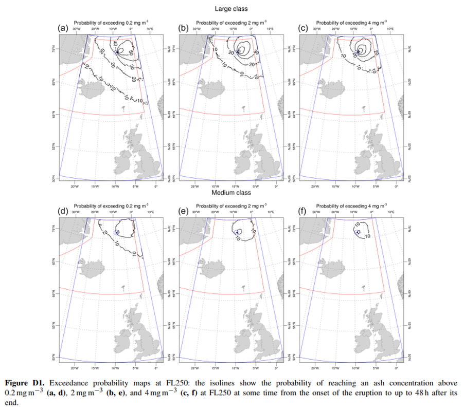
Official, Figure in a journal article
Exceedance probability maps at FL250
Figure D1 in: Titos, M., Martínez Montesinos, B., Barsotti, S., Sandri, L., Folch, A., Mingari, L., Macedonio, G. & Costa, A. (2022). Long-term hazard assessment of explosive eruptions at Jan Mayen (Norway) and implications for air traffic in the North Atlantic. Natural Hazards and Earth System Sciences, 22(1), 139-163. https://doi.org/10.5194/nhess-22-139-2022
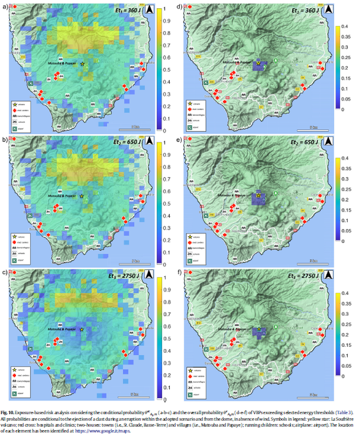
Figure in a journal article
Exposure-based risk analysis considering the conditional probability and the overall probability of VBPs exceeding selected energy thresholds
Figure 10 in: Massaro, S., Rossi, E., Sandri, L., Bonadonna, C., Selva, J., Moretti, R., & Komorowski, J. C. (2022). Assessing hazard and potential impact associated with volcanic ballistic projectiles: The example of La Soufrière de Guadeloupe volcano (Lesser Antilles). Journal of volcanology and geothermal research, 423, 107453. https://doi.org/10.1016/j.jvolgeores.2021.107453