
Advanced Search for Maps
Showing 41-50 of 56
Official, Map sheet or poster
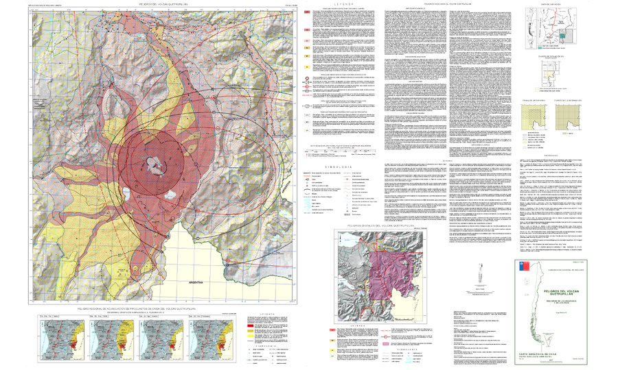
Peligros del Volcán Quetrupillán
(Hazards of the Quetrupillán Volcano)
Moreno, H. (2017). Peligros del Volcán Quetrupillán, Regiones de La Araucanía y de Los Ríos. Servicio Nacional de Geología y Minería, Carta Geológica de Chile, Serie Geología Ambiental 30:1, Escala 1:50.000. Santiago.
Official, Map sheet or poster
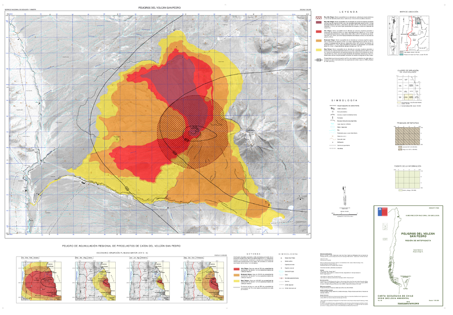
Peligros del Volcán San Pedro
(San Pedro Volcano Hazards)
Bertin, D. & Amigo, A. (2015). Peligros del volcán San Pedro, Región de Antofagasta. Servicio Nacional de Geología y Minería, Carta Geológica de Chile, Serie Geología Ambiente, No., p., 1, mapa escala 1:50.000. Santiago.
Official, Insert/poster-size map with accompanying report
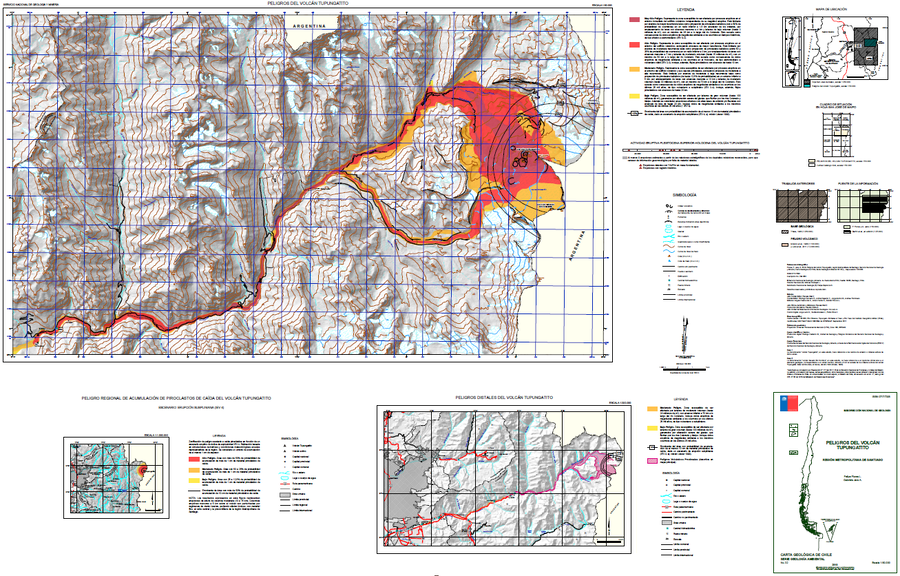
Peligros del Volcán Tupungatito
(Hazards of Tupungatito Volcano)
Flores, F. & Jara, G. (2018). Peligros volcán Tupungatito, Región Metropolitana de Santiago. Servicio Nacional de Geología y Minería (SERNAGEOMIN), Carta Geológica de Chile, Serie Geología Ambiental 32: 35 p., mapa escala 1:50.000. Santiago.
Official, Insert/poster-size map with accompanying report
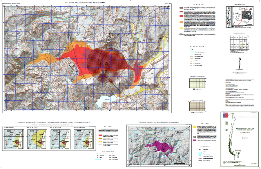
Peligros Volcanicos del Volcán Cerro Azul-Quizapu
(Volcanic Hazards of Cerro Azul-Quizapu Volcano)
Amigo, A. & Bertin, D. (2015). Peligros del volcán Cerro Azul – Quizapu, Región del Maule. Servicio Nacional de Geología y Minería (SERNAGEOMIN), Carta Geológica de Chile, Serie Geología Ambiental, No. 17, p., 1, mapa escala 1:50.000. Santiago.
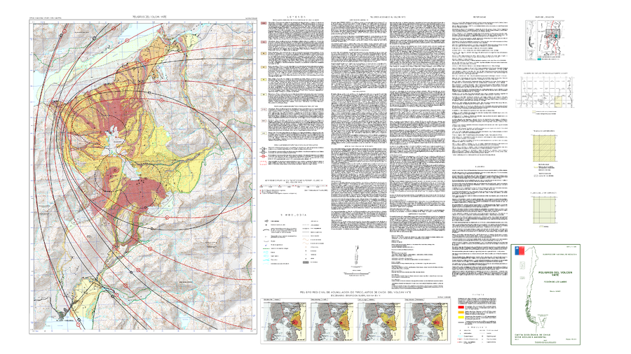
Official, Map sheet or poster
Peligros Volcánicos del Volcán Yate
(Volcanic Hazards of Yate Volcano)
Mella, M. (2017). Peligros del Volcán Yate, región de Los Lagos. Servicio Nacional de Geología y Minería, Carta Geológica de Chile, Serie Geología Ambiental 31, mapa escala 1:50.000. Santiago.
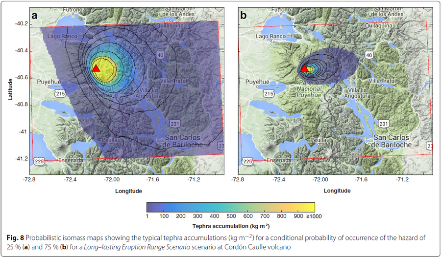
Figure in a journal article
Probabilistic isomass maps showing the typical tephra accumulations (kg m−2) for a conditional probability of occurrence of the hazard
Figure 8 in: Biass, S., Bonadonna, C., Connor, L., & Connor, C. (2016). TephraProb: a Matlab package for probabilistic hazard assessments of tephra fallout. Journal of Applied Volcanology, 5(1), 1-16. https://doi.org/10.1186/s13617-016-0050-5
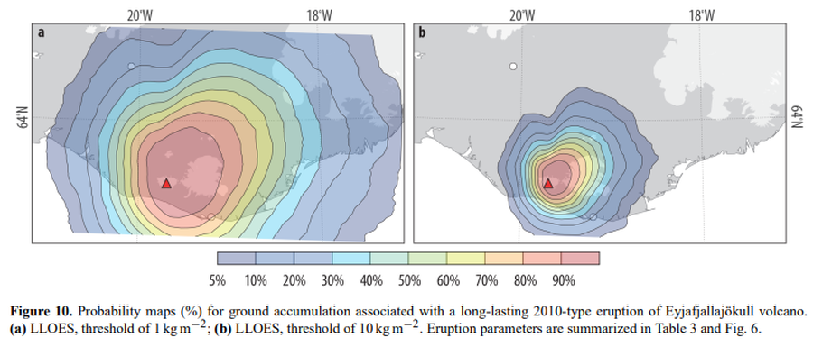
Figure in a journal article
Probability maps (%) for ground accumulation associated with a long-lasting 2010-type eruption of Eyjafjallajökull volcano
Figure 10 in: Biass, S., Scaini, C., Bonadonna, C., Folch, A., Smith, K., & Höskuldsson, A. (2014). A multi-scale risk assessment for tephra fallout and airborne concentration from multiple Icelandic volcanoes–Part 1: Hazard assessment. Natural hazards and earth system sciences, 14(8), 2265-2287. https://doi.org/10.5194/nhess-14-2265-2014
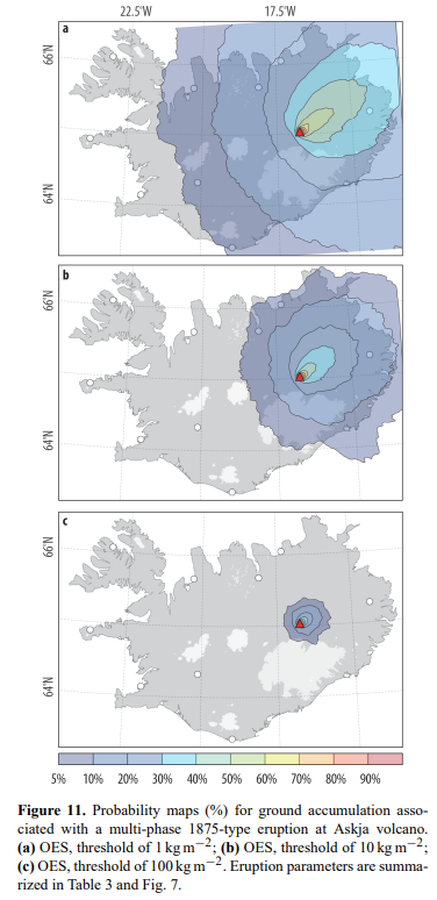
Figure in a journal article
Probability maps (%) for ground accumulation associated with a multi-phase 1875-type eruption at Askja volcano
Figure 11 in: Biass, S., Scaini, C., Bonadonna, C., Folch, A., Smith, K., & Höskuldsson, A. (2014). A multi-scale risk assessment for tephra fallout and airborne concentration from multiple Icelandic volcanoes–Part 1: Hazard assessment. Natural hazards and earth system sciences, 14(8), 2265-2287. https://doi.org/10.5194/nhess-14-2265-2014
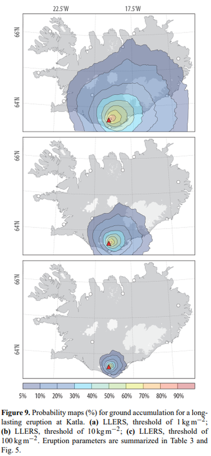
Figure in a journal article
Probability maps (%) for ground accumulation for a longlasting eruption at Katla
Figure 9 in: Biass, S., Scaini, C., Bonadonna, C., Folch, A., Smith, K., & Höskuldsson, A. (2014). A multi-scale risk assessment for tephra fallout and airborne concentration from multiple Icelandic volcanoes–Part 1: Hazard assessment. Natural hazards and earth system sciences, 14(8), 2265-2287. https://doi.org/10.5194/nhess-14-2265-2014
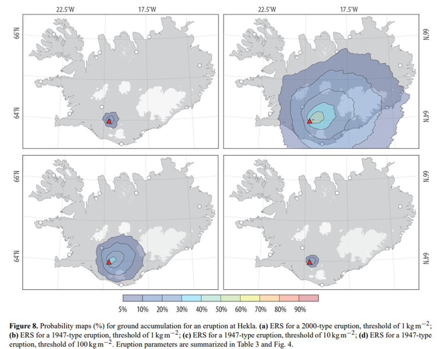
Figure in a journal article
Probability maps (%) for ground accumulation for an eruption at Hekla
Figure 8 in: Biass, S., Scaini, C., Bonadonna, C., Folch, A., Smith, K., & Höskuldsson, A. (2014). A multi-scale risk assessment for tephra fallout and airborne concentration from multiple Icelandic volcanoes–Part 1: Hazard assessment. Natural hazards and earth system sciences, 14(8), 2265-2287. https://doi.org/10.5194/nhess-14-2265-2014