
Advanced Search for Maps
Showing 41-50 of 100
Official, Map sheet or poster
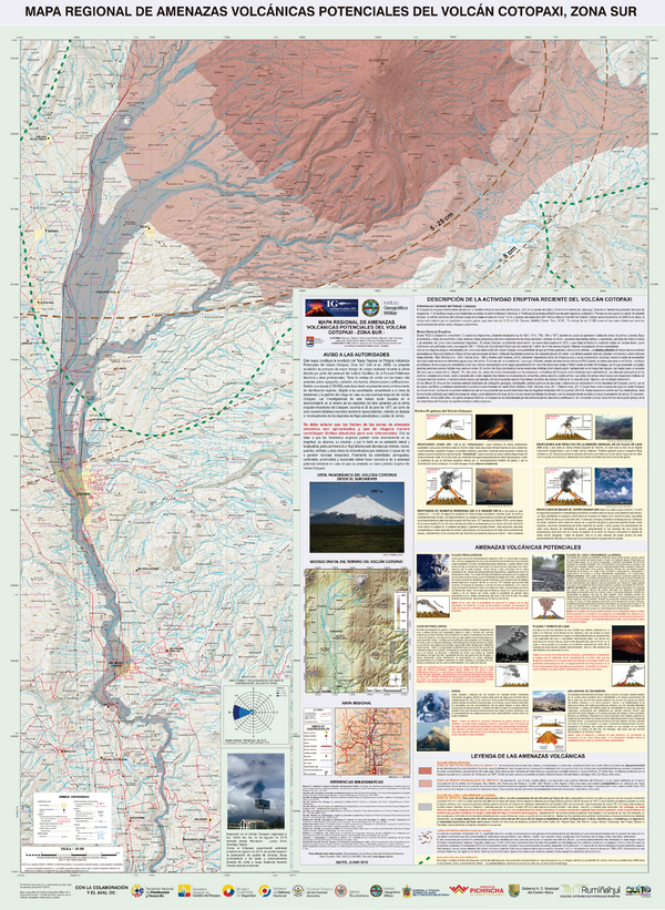
Mapa Regional de Amenazas Volcánicas Potenciales del Volcán Cotopaxi, Zona Sur
(Regional Map of Potential Volcanic Hazards of Cotopaxi Volcano, South Zone)
Mothes, P.A., Espín Bedón, P.E., Hall, M.L., Vásconez, F., Sierra, D., Córdova, M., & Santamaría, S. (2016). Mapa Regional de Amenazas Volcánicas Potenciales del Volcán Cotopaxi, Zona Sur. Instituto Geofísico de la Escuela Politecnica Nacional (IG-EPN) & Instituto Geográfico Militar (IGM), mapa escala 1:50.000. Quito.

Official, Map sheet or poster
Mapa Regional de Peligros Volcánicos Potenciales del Volcán Cotopaxi - Zona Sur
(Regional Map of Potential Volcanic Hazards of Cotopaxi Volcano, South Zone)
Hall, M.L., Mothes, P., Samaniego, P., Yepes, H., & Andrade, D. (2004). Mapa Regional de Peligros Volcánicos Potenciales del Volcán Cotopaxi - Zona Sur. Instituto Geofisico de la Escuela Politecnica Nacional (IG-EPN) & Institut de Recherche pour le Développement (IRD), mapa escala 1:50.000. Quito.

Official, Map sheet or poster
Mapas de los Peligros Potenciales del Volcán Reventador
(Maps of the Potential Hazards of Reventador Volcano)
Bourquin, J., Samaniego, P., Ramón, P., Bonadonna, C., Kelfoun, K., Vallejo, S., Hall, P., Mothes, P., LePennec, J.L., & Yepes, H. (2011). Mapas de los Peligros Potenciales del Volcán Reventador. Instituto Geofisico de la Escuela Politecnica Nacional (IG-EPN), Instituto de Recherche pour le Dévoloppement (IRD), & Universidad de Ginebra, Centre d’Etude des Risques Géologiques (CERG). Quito.
Official, Figure in hazard assessment
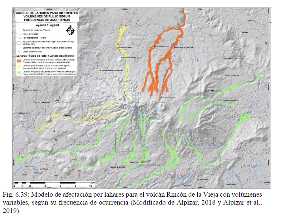
Modelo de Lahares para Diferentes Volumenes de Flujo Según Frecuencia de Ocurrencia
(Lahar Model for Different Flow Volumes According to Frequency of Occurrence)
Figure 6.39 in: Alvarado, G.E., Brenes-André, J., Venegas, L., Alpízar, Y., Núñez, S., Sánchez, M., Abarca, K., Abarca, J., Báez, W.A., Sibaja, J.P., Esquivel, L., & Arcia, T. (2022). Análisis del Peligro Volcánico del Rincón de la Vieja, Costa Rica. Instituto Costarricense de Electricidad (ICE). Setiembre 2022. (Modified from: Alpízar, 2018 & Alpízar et al. 2019)
Official, Map sheet or poster
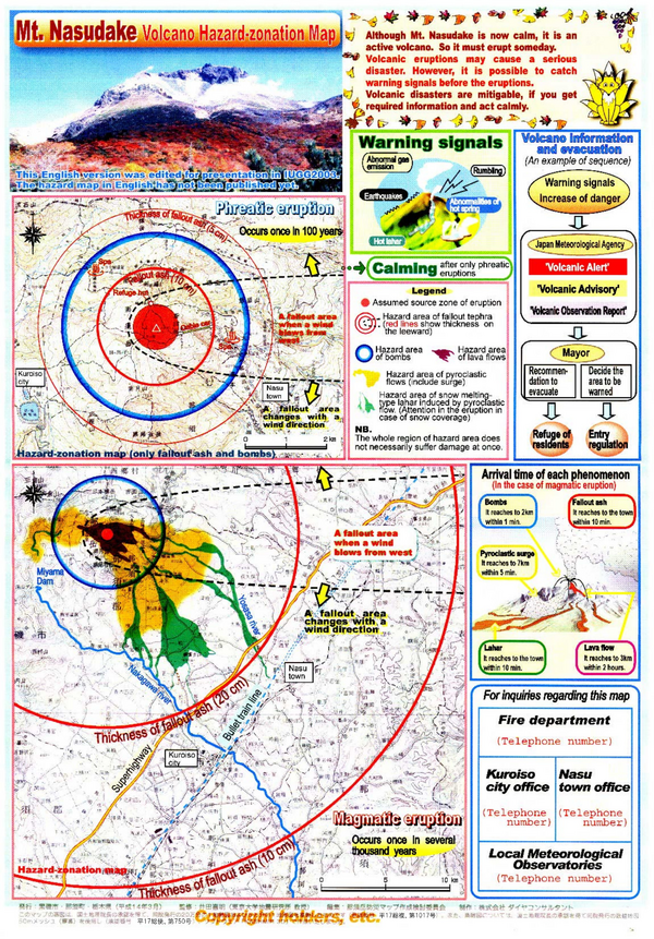
Mt. Nasudake Volcano Hazard-zonation Map
Nasudake Volcano Disaster Prevention Committee. (2003). Mt. Nasudake Volcano Hazard-Zonation Map. International Union of Geodesy and Geophysics (IUGG) General Assembly, Sapporo, Japan.
Official, Map sheet or poster
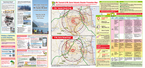
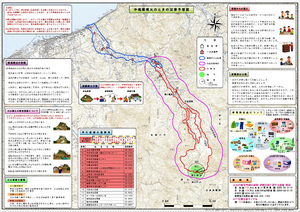
Mt. Tsurumi, Mt. Garan Volcano Disaster Prevention Guide (for mountain climbers and tourists)
Tsurumidake & Garandake Volcano Disaster Prevention Council. (2016). Tsurumidake and Garandake Volcano Disaster Prevention Map (for mountain climbers and tourists). Beppu City, Yufu City, Usa City, Hiji Town, and Oita Prefecture.
Official, Map sheet or poster
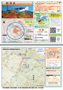
Nasudake Volcano Disaster Prevention Map (for climbers)
Nasudake Volcano Disaster Prevention Association. (2015). Nasudake Volcano Disaster Prevention Map (for climbers).
Official, Map sheet or poster
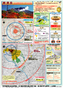
Nasudake Volcano Disaster Prevention Map (revised version)
Nasudake Volcano Disaster Prevention Association. (2010). Nasudake Volcano Disaster Prevention Map (revised version).
Official, Map sheet or poster
Niigata Yakeyama Volcano Disaster Prevention Map
Niigata Prefecture & Itoigawa City. (2004). Niigata Yakeyama Volcano Disaster Prevention Map.
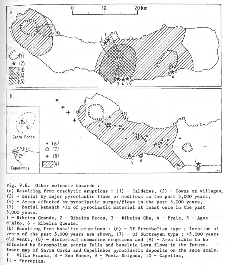
Figure in a journal article
Other volcanic hazards
Figure 9.6 in: Booth, B., Croasdale, R., & Walker, G.L. (1983). Volcanic hazard on Sao Miguel, Azores. In: Tazieff, H. & Sabroux, J.C. (eds.). Forecasting Volcanic Events. Elsevier, Amsterdam. p. 99-109.