
Advanced Search for Maps
Showing 51-60 of 100
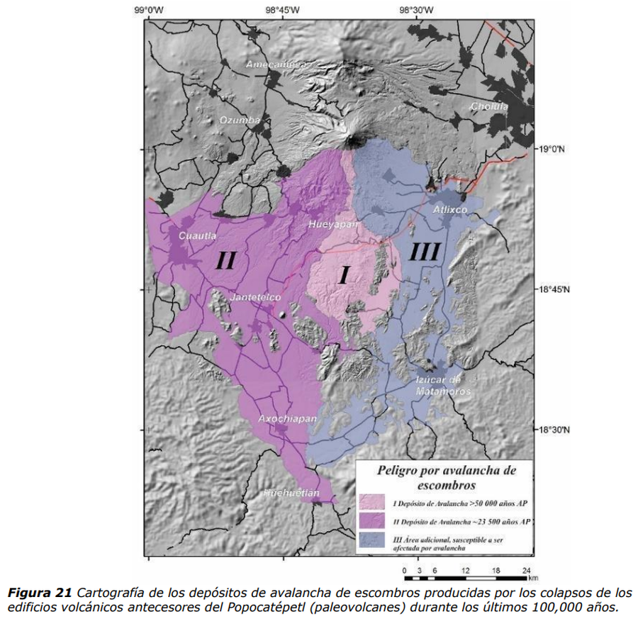
Official, Figure in hazard assessment
Peligro por avalancha de escombros
(Debris avalanche hazard)
Figure 21 in: Martin Del Pozzo, A.L, Alatorre Ibargüengoitia M., Arana Salinas L., Bonasia R., Capra Pedol L., Cassata W., Cordoba G., Cortés Ramos J., Delgado Granados H., Ferrés López M.D., Fonseca Álvarez R., García Reynoso J.A., Gisbert G., Guerrero López D.A., Jaimes Viera M., Macías Vázquez J.L., Nieto Obregon J., Nieto Torres A., Paredes Ruiz P.A., Portocarrero Martínez J., Renne P., Rodríguez Espinosa D.M., Salinas Sánchez S., Siebe Grabach C., & Tellez Ugalde E. (2017). Estudios geológicos y actualización del mapa de peligros del volcán Popocatépetl. Memoria técnica del mapa de peligros del volcán Popocatépetl. Instituto de Geofísica, Universidad Nacional Autónoma de México (UNAM).
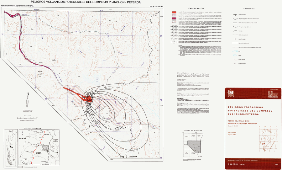
Official, Map sheet or poster
Peligros Volcánicos Potenciales del Complejo Planchón-Peteroa
(Potential Volcanic Hazards of the Planchón-Peteroa Complex)
Naranjo, J.A., & Haller, M.J. (1999). Peligros Volcánisoc Potenciales del Complejo Planchon-Peteroa, Región del Maule, Chile - Provincia de Mendoza, Argentina. Servcio Nacional de Geología y Minería (SERNAGEOMIN), Boletín No. 52, 55 p., 2 mapas escala 1:100.000.
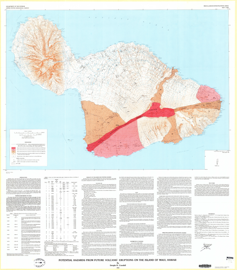
Official, Map sheet or poster
Potential Hazards from Future Volcanic Eruptions of the Island of Maui, Hawaii
Plate 1 in: Crandell, D.R. (1983). Potential hazards from future volcanic eruptions on the Island of Maui, Hawaii. U.S. Geological Survey, IMAP 1442. https://doi.org/10.3133/i1442
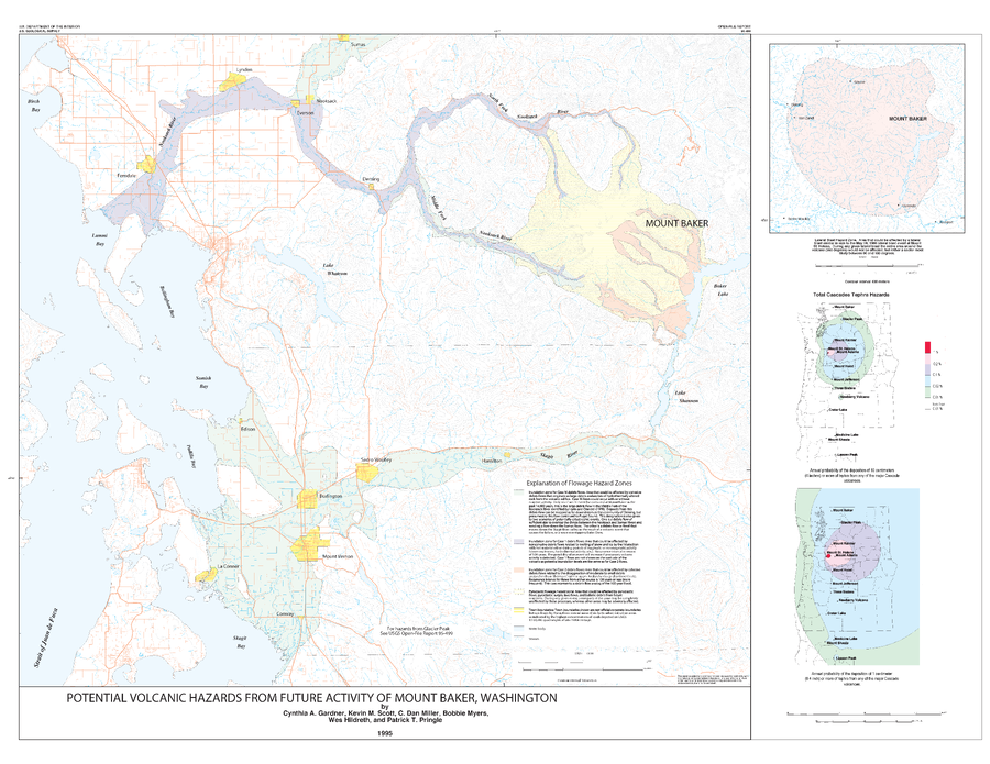
Official, Insert/poster-size map with accompanying report
Potential Volcanic Hazards from Future Activity of Mount Baker, Washington
Plate 1 in: Gardner, C.A., Scott, K.M., Miller, C.D., Myers, B., Hildreth, W., & Pringle, P.T. (1995). Potential volcanic hazards from future activity of Mount Baker, Washington. U.S. Geological Survey, Open-File Report 95-498, 16 p., 1 plate, scale 1:100,000. https://doi.org/10.3133/ofr95498
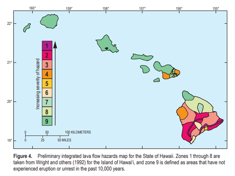
Official, Figure in a journal article
Preliminary integrated lava flow hazards map for the State of Hawaii
Figure 4 in: Kauahikaua, J.P. & Tilling, R.I. (2014). Natural hazards and risk reduction in Hawai‘i. In: Poland, M.P., Takahashi, T.J., & Landowski, C.M. (eds.) Characteristics of Hawaiian Volcanoes. US Geological Survey Professional Paper 1801, p. 397-427. https://doi.org/10.3133/pp180110
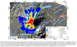
Figure in a journal article
Pyroclastic flow hazard map of Arenal corresponding to the “current” hazard scenario (Scenario 1)
Figure 8 in: Oramas-Dorta, D., Cole, P. D., Wadge, G., Alvarado, G. E., & Soto, G. J. (2012). Pyroclastic flow hazard at Arenal volcano, Costa Rica: Scenarios and assessment. Journal of volcanology and geothermal research, 247, 74-92. https://doi.org/10.1016/j.jvolgeores.2012.07.015

Figure in a journal article
Pyroclastic flow hazard map of Arenal corresponding to the “near-future” hazard scenario (Scenario 2)
Figure 9 in: Oramas-Dorta, D., Cole, P. D., Wadge, G., Alvarado, G. E., & Soto, G. J. (2012). Pyroclastic flow hazard at Arenal volcano, Costa Rica: Scenarios and assessment. Journal of volcanology and geothermal research, 247, 74-92. https://doi.org/10.1016/j.jvolgeores.2012.07.015
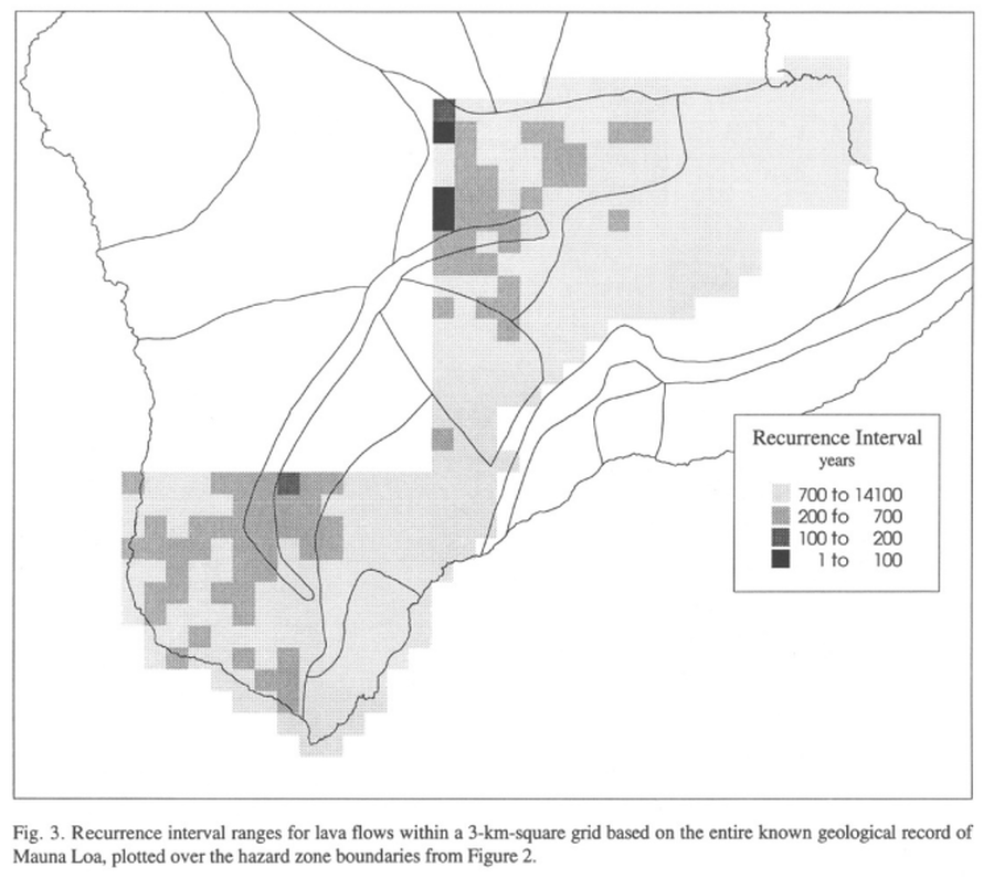
Official, Figure in a journal article
Recurrence interval ranges for lava flows within a 3-km-square grid based on the entire known geological record of Mauna Loa
Figure 3 in: Kauahikaua, J., Margriter, S., Lockwood, J., & Trusdell, F. (1995). Applications of GIS to the estimation of lava flow hazards on Mauna Loa Volcano, Hawai'i. Washington DC American Geophysical Union Geophysical Monograph Series, 92, 315-325. https://doi.org/10.1029/GM092p0315

Official, Figure in a journal article
Recurrence interval ranges for lava flows within a 3-km-square grid based on the geologic record of Mauna Loa from the last 150 years
Figure 4 in: Kauahikaua, J., Margriter, S., Lockwood, J., & Trusdell, F. (1995). Applications of GIS to the estimation of lava flow hazards on Mauna Loa Volcano, Hawai'i. Washington DC American Geophysical Union Geophysical Monograph Series, 92, 315-325. https://doi.org/10.1029/GM092p0315

Official, Figure in a journal article
Recurrence intervals for lava flows erupted between 1843 and the present within topographically-defined catchments
Figure 5 in: Kauahikaua, J., Margriter, S., Lockwood, J., & Trusdell, F. (1995). Applications of GIS to the estimation of lava flow hazards on Mauna Loa Volcano, Hawai'i. Washington DC American Geophysical Union Geophysical Monograph Series, 92, 315-325. https://doi.org/10.1029/GM092p0315