
Advanced Search for Maps
Showing 21-30 of 100
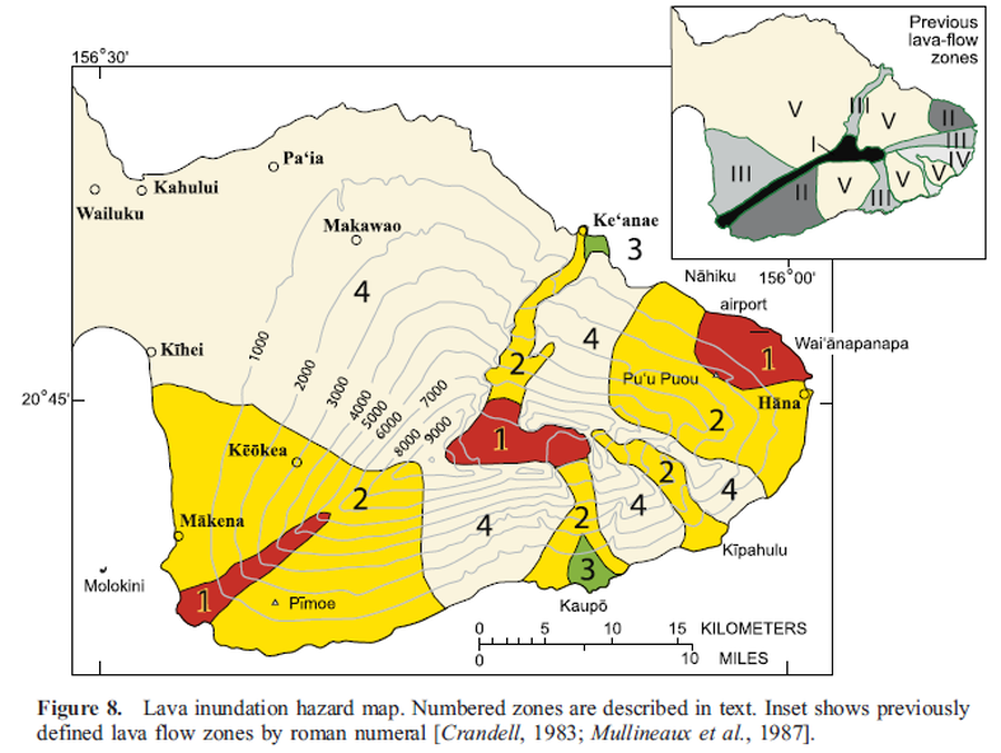
Official, Figure in a journal article
Lava inundation hazard map
Figure 8 in: Sherrod, D. R., Hagstrum, J. T., McGeehin, J. P., Champion, D. E., & Trusdell, F. A. (2006). Distribution, 14C chronology, and paleomagnetism of latest Pleistocene and Holocene lava flows at Haleakalā volcano, Island of Maui, Hawai ‘i: A revision of lava flow hazard zones. Journal of Geophysical Research: Solid Earth, 111(B5).
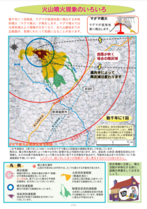
Official, Map in a booklet, long fact-sheet, or handbook
Magma eruption hazard map
Page 7 in: Nasudake Volcano Disaster Prevention Council. (2014). Nasudake Volcano Disaster Prevention Handbook.
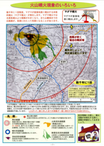
Official, Map in a booklet, long fact-sheet, or handbook
Magma eruption hazard map
Page 7 in: Nasudake Volcano Disaster Prevention Council. (2010). Volcanic disaster prevention handbook of Mt. Nasudake.
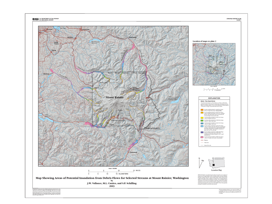
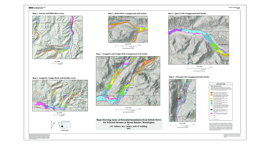
Official, Insert/poster-size map with accompanying report
Map Showing Areas of Potential Inundation from Debris Flows for Selected Streams at Mount Rainier, Washington
Plate 1 in: Vallance, J.W., Cunico, M.L. & Schilling, S.P. (2003). Debris-flow hazards caused by hydrologic events at Mount Rainier, Washington. U.S. Geological Survey, Open-File Report 03-368, 4 p., 2 plates. https://doi.org/10.3133/ofr03368
Official, Insert/poster-size map with accompanying report
Map Showing Areas of Potential Inundation from Debris Flows for Selected Streams at Mount Rainier, Washington
Plate 2 in: Vallance, J.W., Cunico, M.L. & Schilling, S.P. (2003). Debris-flow hazards caused by hydrologic events at Mount Rainier, Washington. U.S. Geological Survey, Open-File Report 03-368, 4 p., 2 plates. https://doi.org/10.3133/ofr03368
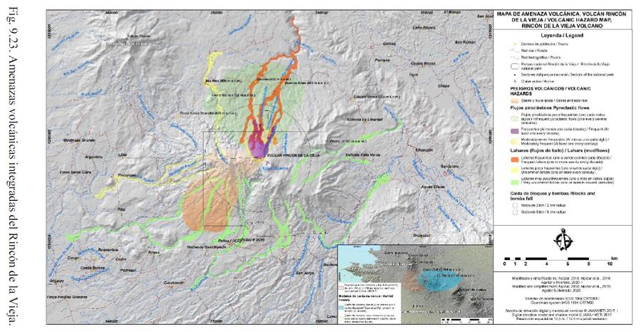
Official, Figure in hazard assessment
Mapa de Amenaza Volcánica, Volcán Rincón de la Vieja
(Volcanic Hazard Map, Rincón de la Vieja Volcano)
Figure 9.23 in: Alvarado, G.E., Brenes-André, J., Venegas, L., Alpízar, Y., Núñez, S., Sánchez, M., Abarca, K., Abarca, J., Báez, W.A., Sibaja, J.P., Esquivel, L., & Arcia, T. (2022). Análisis del Peligro Volcánico del Rincón de la Vieja, Costa Rica. Instituto Costarricense de Electricidad (ICE). Setiembre 2022.
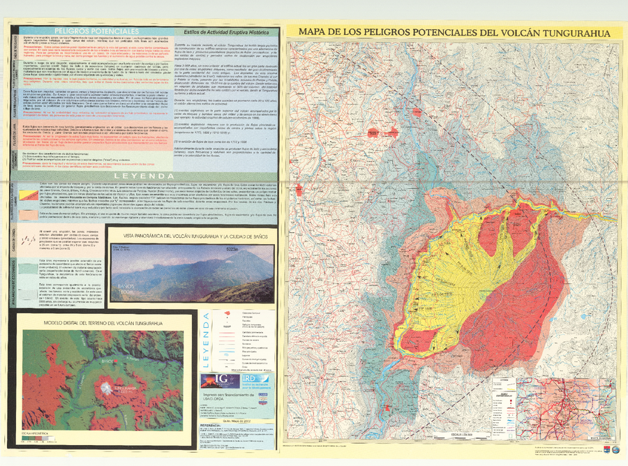
Official, Map sheet or poster
Mapa de los peligros potenciales asociados del Volcán Tungurahua
(Map of the potential hazards associated with the Tungurahua Volcano)
Hall, M.L., Robin, C., Beate, B., Mothes, P., & Monzier, M. (2002). Mapa de los peligros potenciales asociados del Volcán Tungurahua. Instituto Geofísico, Escuela Politécnica Nacional (IG-EPN), Quito.
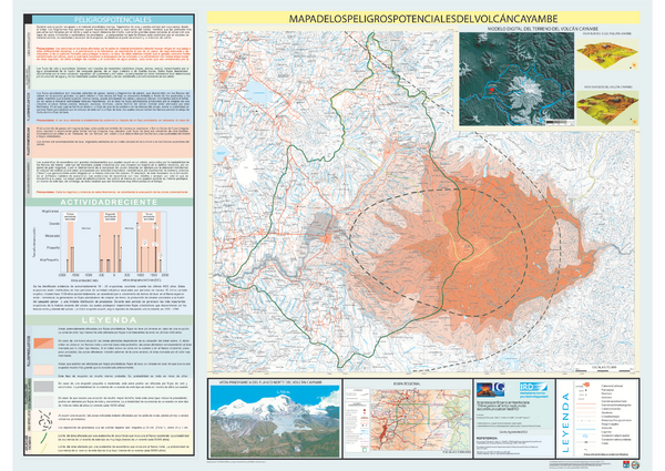
Official, Map sheet or poster
Mapa de los Peligros Potenciales del Volcán Cayambe
(Cayambe Volcano Potential Hazards Map)
Samaniego, P., Monzier, M., Robin, C., Eissen, J.P., Hall, M.L., Mothes, P., & Yepes, H. (2002). Mapa del los Peligros Potentiales del Volcán Cayambe. Instituto Geofisico de la Escuela Politecnica Nacional (IG-EPN), mapa escala 1:70.000. Quito.
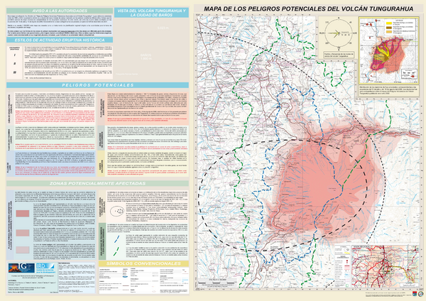
Official, Map sheet or poster
Mapa de los Peligros Potenciales del Volcán Tungurahua
(Map of the Potencial Hazards of Tungurahua Volcano)
Samaniego, P., Le Pennec, J.-L., Barba, D., Hall, M.L., Robin, C., Mothes, P., Yepes, H., Troncoso, L., & Jaya, D. (2008). Mapa de los Peligros Potenciales del Volcán Tungurahua, 3rd Edición. Instituto Geofisico Escuela Politécnica Nacional (IG-EPN) & Institut de Recherche pour la Développement (IRD), Quito.
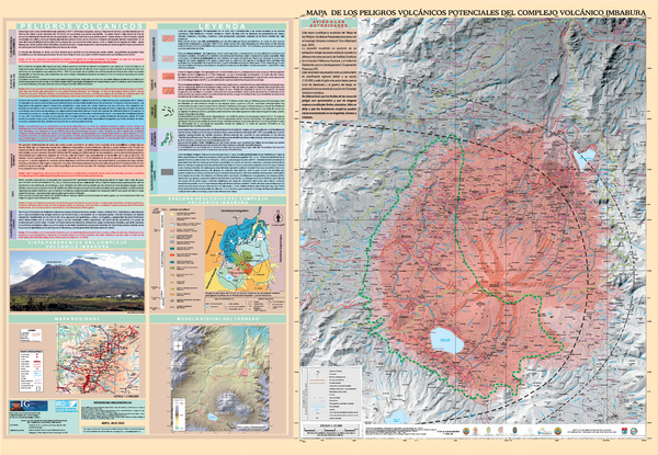
Official, Map sheet or poster
Mapa de los Peligros Volcánicos Potenciales del Complejo Volcánico Imbabura
(Map of the Potential Volcanic Hazards of the Imbabura Volcanic Complex)
Ruiz, A.G., Le Pennec, J.-L., Hall, M.L., Samaniego, P. (2005). Mapa de los Peligros Volcánicos Potenciales del Complejo Volcánico Imbabura. Instituto Geofisico de la Escuela Politecnica Nacional (IG-EPN) & Institut de Recherche pour le Développement (IRD), mapa escala 1:50.000. Quito.