
Advanced Search for Maps
Showing 61-70 of 100
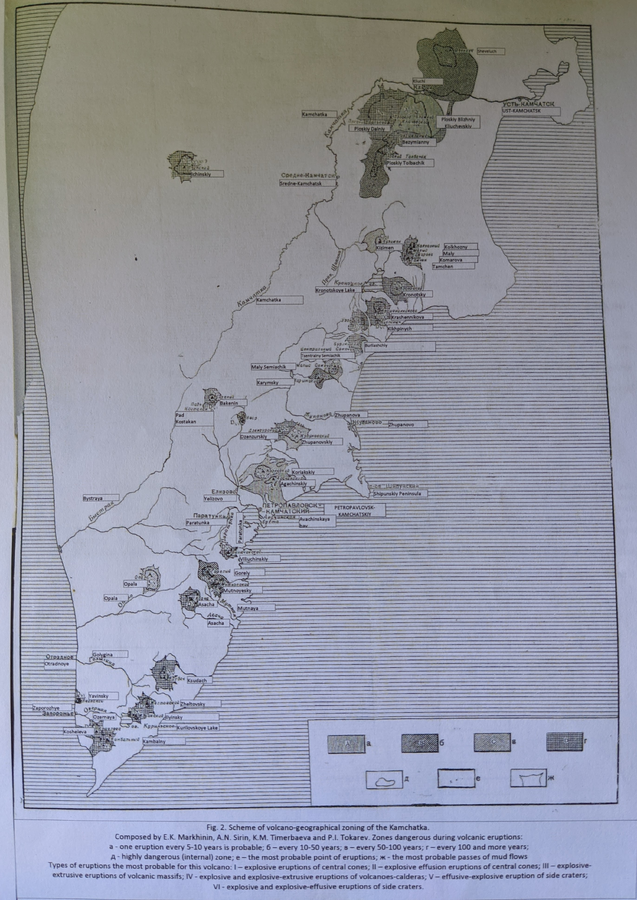
Official, Figure in a journal article
Scheme of volcano-geographical zoning in Kamchatka
Figure 2 in: Markhinin, E. K., Sirin, A. N., Timerbayeva, K. M., & Tokarev, P. I. (1962). Experience of volcanic-geographic zoning of Kamchatka and Kuril Islands. Bulletin of the Volcanological Station, Petropavlousk, Kamchatskiy, USSR, 32, 52-70.
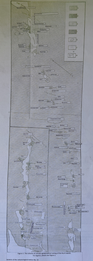
Official, Figure in a journal article
Scheme of volcano-geographical zoning in the Kuril Islands
Figure 3 in: Markhinin, E. K., Sirin, A. N., Timerbayeva, K. M., & Tokarev, P. I. (1962). Experience of volcanic-geographic zoning of Kamchatka and Kuril Islands. Bulletin of the Volcanological Station, Petropavlousk, Kamchatskiy, USSR, 32, 52-70.
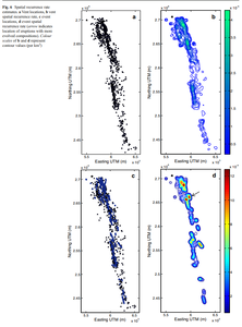
Figure in a journal article
Spatial recurrence rate estimates
Figure 6 in: Runge, M. G., Bebbington, M. S., Cronin, S. J., Lindsay, J. M., Kenedi, C. L., & Moufti, M. R. H. (2014). Vents to events: determining an eruption event record from volcanic vent structures for the Harrat Rahat, Saudi Arabia. Bulletin of Volcanology, 76(3), 1-16. https://doi.org/10.1007/s00445-014-0804-z

Official, Map in a booklet, long fact-sheet, or handbook
Steam eruption risk area prediction map (ash fall, volcanic blocks only)
Page 6 in: Nasudake Volcano Disaster Prevention Council. (2014). Nasudake Volcano Disaster Prevention Handbook.

Official, Map in a booklet, long fact-sheet, or handbook
Steam eruption risk area prediction map (ash fall, volcanic blocks only)
Page 6 in: Nasudake Volcano Disaster Prevention Council. (2010). Volcanic disaster prevention handbook of Mt. Nasudake.
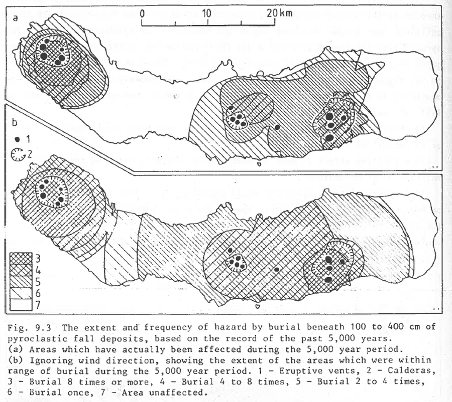
Figure in a journal article
The extent and frequency of hazard from burial beneath 100 to 400 cm of pyroclastic fall deposits, based on the record of the past 5,000 years
Figure 9.3 in: Booth, B., Croasdale, R., & Walker, G.L. (1983). Volcanic hazard on Sao Miguel, Azores. In: Tazieff, H. & Sabroux, J.C. (eds.). Forecasting Volcanic Events. Elsevier, Amsterdam. p. 99-109.
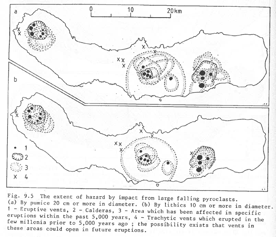
Figure in a journal article
The extent of hazard by impact from large falling pyroclasts
Figure 9.5 in: Booth, B., Croasdale, R., & Walker, G.L. (1983). Volcanic hazard on Sao Miguel, Azores. In: Tazieff, H. & Sabroux, J.C. (eds.). Forecasting Volcanic Events. Elsevier, Amsterdam. p. 99-109.
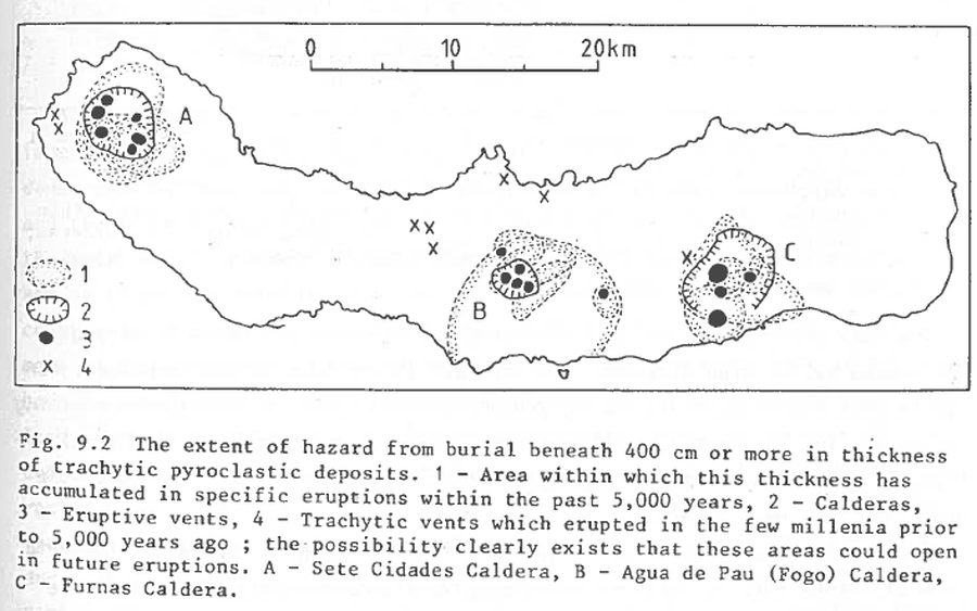
Figure in a journal article
The extent of hazard from burial beneath 400 cm or more in thickness of trachytic pyroclastic deposits
Figure 9.2 in: Booth, B., Croasdale, R., & Walker, G.L. (1983). Volcanic hazard on Sao Miguel, Azores. In: Tazieff, H. & Sabroux, J.C. (eds.). Forecasting Volcanic Events. Elsevier, Amsterdam. p. 99-109.
Official, Map sheet or poster
Tsurumidake and Garandake volcano disaster prevention map
Tsurumidake & Gayandake Volcano Disaster Prevention Council. (2015). Tsurumidake and Garandake volcano disaster prevention map. Beppu City, Yufu City, Usa City, Hiji Town, and Oita Prefecture.
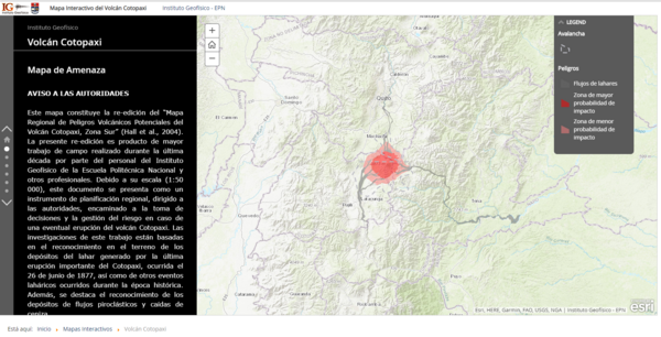
Official, Interactive web-based map
Volcán Cotopaxi Mapa de Amenaza
(Cotopaxi Volcano Hazard Map)
Instituto Geofísico de la Escuela Politecnica Nacional (IG-EPN). (2019). Volcán Cotopaxi Mapa de Amenaza. Instituto Geofísico de la Escuela Politecnica Nacional, Mapa Interactivo del Volcán Cotopaxi. https://www.igepn.edu.ec/cotopaxi