
Advanced Search for Maps
Showing 51-60 of 240
Official, Figure in hazard assessment
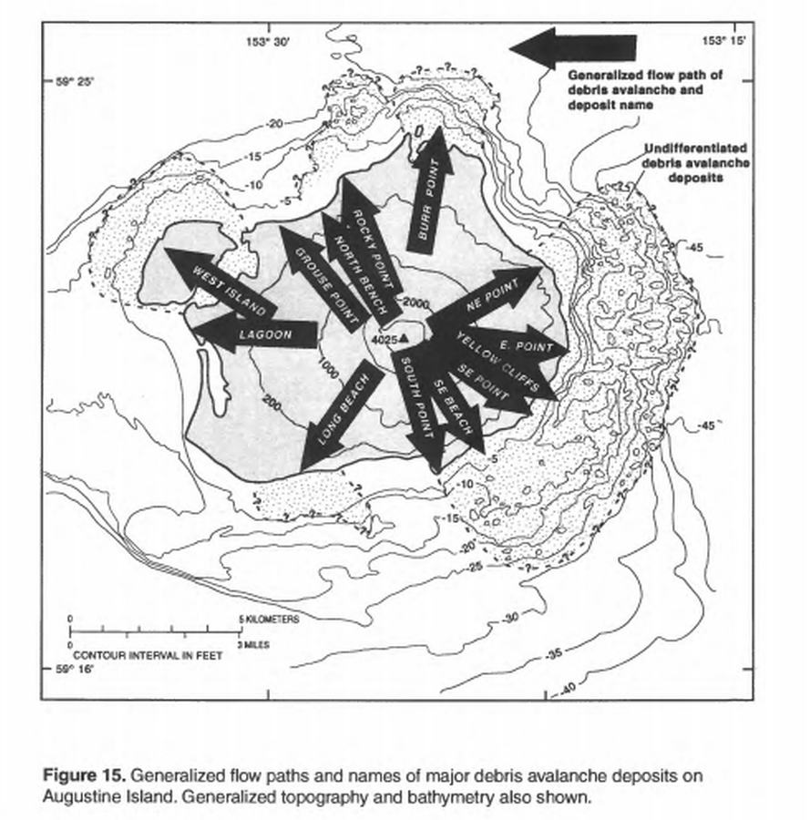
Generalized flow paths and names of major debris avalanche deposits on Augustine Island
Figure 15 in: Waythomas, C.F. & Waitt, R. (1998). Preliminary volcano-hazard assessment for Augustine Volcano, Alaska. U.S. Geological Survey, Open-File Report 98-106. https://doi.org/10.3133/ofr98106
Official, Insert/poster-size map with accompanying report
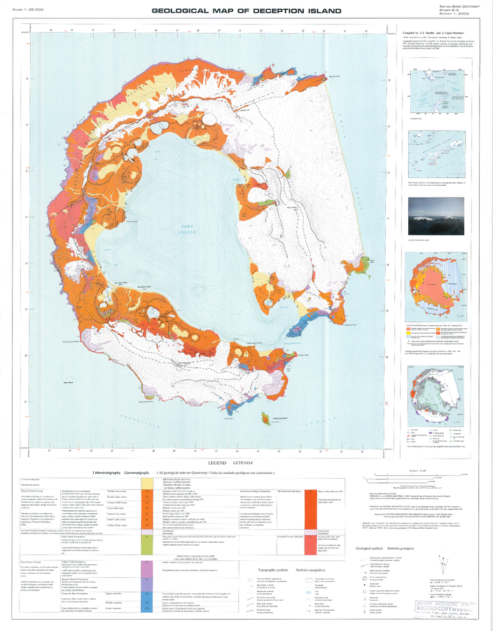
Geologic Map of Deception Island
Sheet 6-A in: Smellie, J.L., López-Martínez, J., Headland, R.K., Hernández-Cifuentes, F., Maestro, A., Millar, I.L., Rey, J., Serrano, E., Somoza, L., & Thomson, J.W. (2002). Geology and geomorphology of Deception Island. Cambridge, British Antarctic Survey, 77 p. (BAS Geomap Series, Sheets 6A and 6B).
Official, Insert/poster-size map with accompanying report
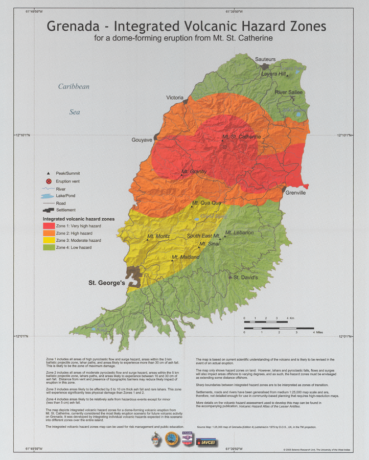
Grenada - Integrated volcanic hazard map for a dome-forming eruption from Mt. St. Catherine
Pocket Insert in: Robertson, R. (2005). Grenada. In: Lindsay, J.M., Shepherd, J.B., Robertson, R.E.A., & Ali, S. (Eds) Volcanic hazard atlas of the Lesser Antilles. Seismic Research Unit, The University of the West Indies, Trinidad and Tobago, W.I., p. 49-66

Official, Insert/poster-size map with accompanying report
Guadeloupe - Integrated Volcanic Hazard Zones for the areas most likely to be affected in the five eruptive scenarios defined for an eruption from a vent on or within 1 km the Soufrière dome and within the S-SW oriented most-recent edifice collapse depression and with the assumption of the presence of easterly trade winds between 0 and 5-8 km altitude
Pocket insert in: Komorowski, J.-C., Boudon, G., Michel-Semet, Beauducel, F., Anténor-Habazac, C., Bazin, S., & Hammouya, G. (2005). Guadeloupe. In: Lindsay, J.M., Shepherd, J.B., Robertson, R.E.A., & Ali, S. (Eds) Volcanic hazard atlas of the Lesser Antilles. Seismic Research Unit, The University of the West Indies, Trinidad and Tobago, W.I., p. 68-106.
Official, Map sheet or poster
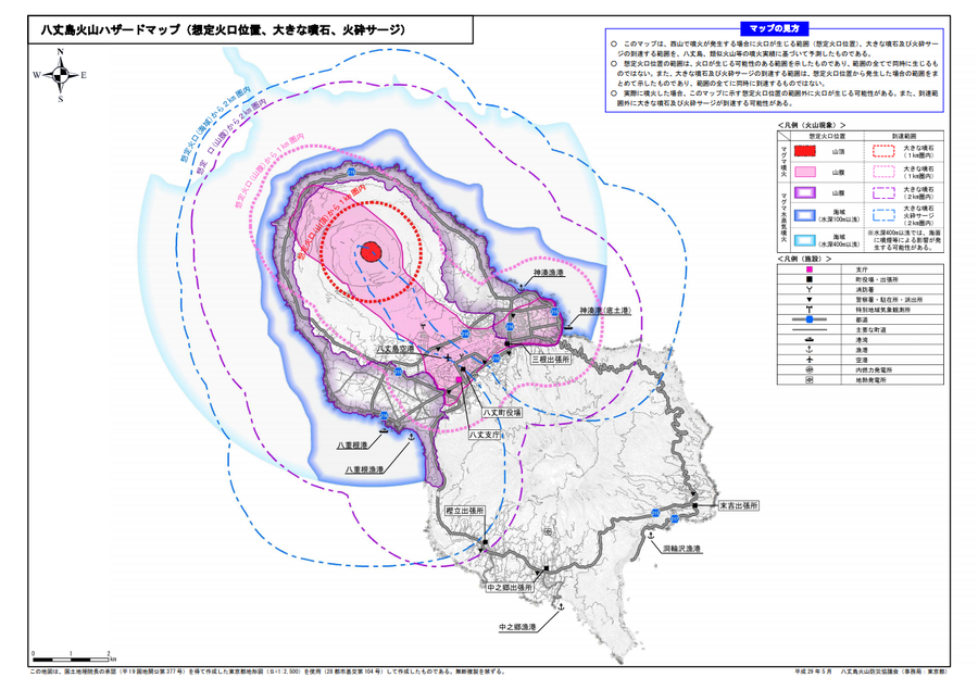
Hachijojima volcano hazard map (assumed crater position, volcanic blocks, pyroclastic surge)
Hachijojima Volcano Disaster Prevention Council. (2017). Hachijojima volcano hazard map. Disaster Prevention Division, Bureau of General Affairs, Tokyo Metropolitan Government.
Official, Map sheet or poster
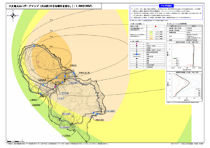
Hachijojima volcano hazard map (volcanic ash including volcanic lapilli: 16 million m³ DRE)
Hachijojima Volcano Disaster Prevention Council. (2017). Hachijojima volcano hazard map. Disaster Prevention Division, Bureau of General Affairs, Tokyo Metropolitan Government.
Official, Map sheet or poster
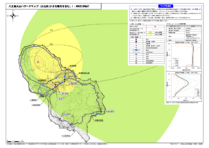
Hachijojima volcano hazard map (volcanic ash including volcanic lapilli: 4 million m³ DRE)
Hachijojima Volcano Disaster Prevention Council. (2017). Hachijojima volcano hazard map. Disaster Prevention Division, Bureau of General Affairs, Tokyo Metropolitan Government.

Official, Map sheet or poster
Hachijojima volcano hazard map (volcanic ash including volcanic lapilli: 40 million m³ DRE)
Hachijojima Volcano Disaster Prevention Council. (2017). Hachijojima volcano hazard map. Disaster Prevention Division, Bureau of General Affairs, Tokyo Metropolitan Government.
Official, Figure on website
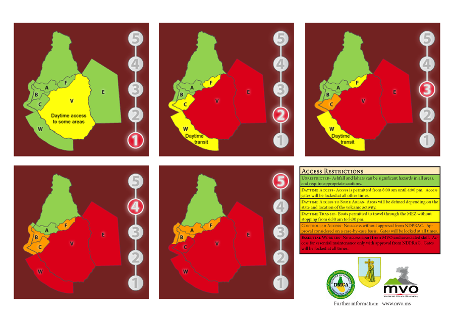
Hazard Level System
Montserrat Volcano Observatory (MVO). (Year Unknown). Hazard Level System. Soufrière Hills Volcano, Monsterrat, Hazards Level System.
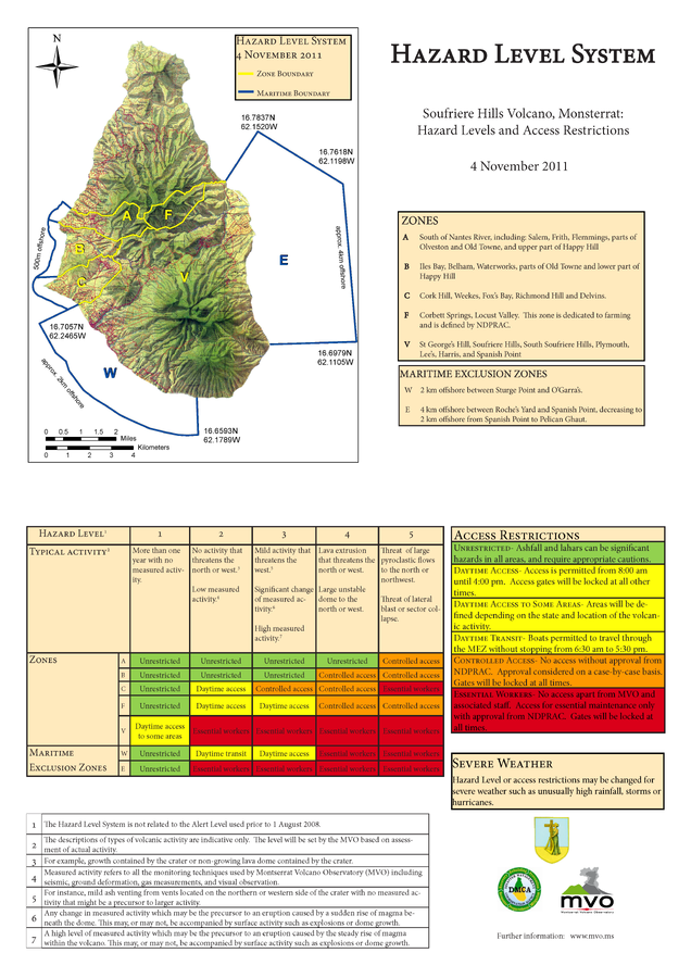
Official, Figure on website
Hazard Level System Soufriere Hills Volcano, Monsterrat: Hazard Levels and Access Restrictions 4 November 2011
Montserrat Volcano Observatory (MVO). (2011) Hazard Level System. Soufriere Hills Volcano, Monsterrat: Hazard Levels and Access Restrictions 4 November 2011. http://www.mvo.ms/pub/Hazard_Level_System/HLS-20111104.pdf