
Advanced Search for Maps
Showing 61-70 of 240

Official, Figure on website
Hazard Level: 1
Montserrat Volcano Observatory (MVO). (Year Unknown). Hazard Level. Retrieved 29 March, 2022, from http://www.mvo.ms/
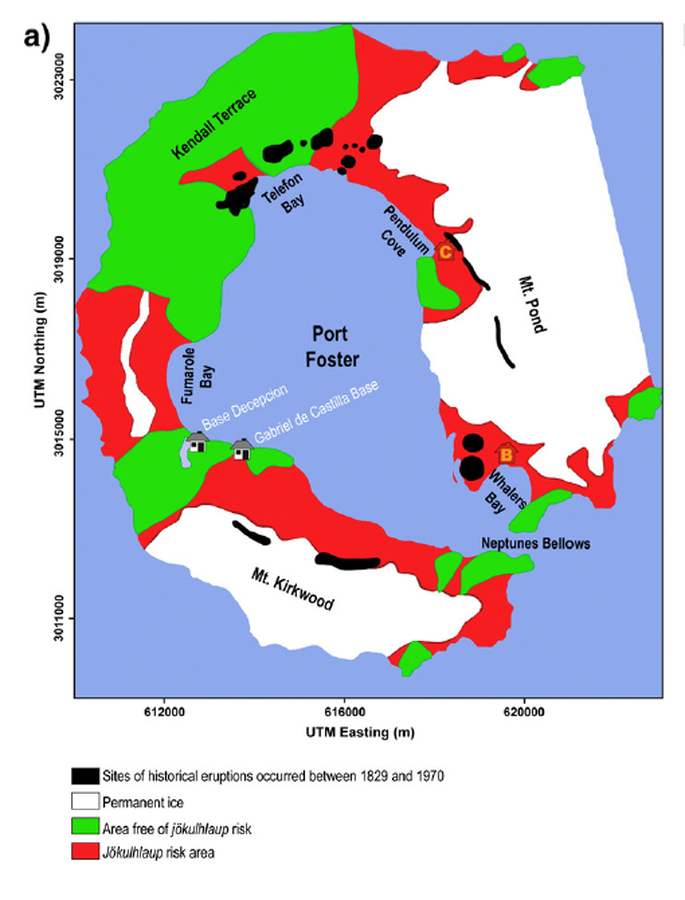
Figure in a journal article
Hazard map presented by Roobol (1982)
Figure 5 (in reprint) in: Roobol, M.J. (1982). The volcanic hazard at Deception Island, South Shetland Islands. British Antarctic Survey. 51, 237-245. (Reprinted in: Bartolini, S., Geyer, A., Martí, J., Pedrazzi, D., & Aguirre-Díaz, G. (2014). Volcanic hazard on Deception Island (South Shetland Islands, Antarctica). Journal of Volcanology and Geothermal Research, 285, p. 150-168. https://doi.org/10.1016/j.jvolgeores.2014.08.009)
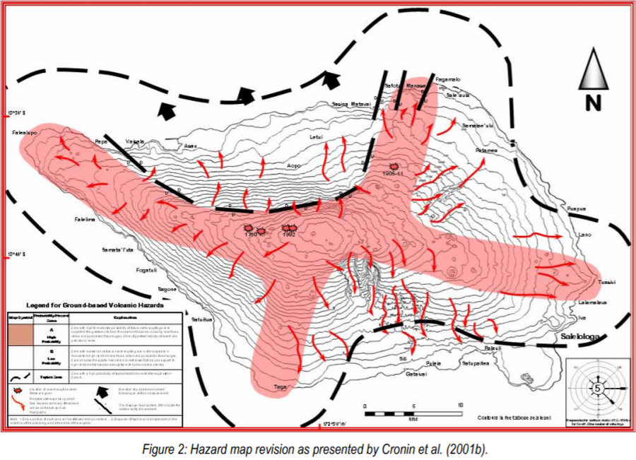
Official, Figure in hazard assessment
Hazard map revision as presented by Cronin et al. (2001b)
Figure 2 in: Cronin, S., Bonte-Grapentin, M. & Nemeth, K. (2006). Samoa technical report - Review of volcanic hazard maps for Savai'i and Upolu. Pacific Islands Applied Geoscience Commission (SOPAC) Project Report 59.
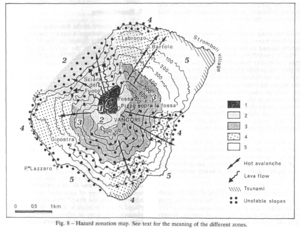
Figure in a journal article
Hazard zonation map
Figure 8 in: Barberi, F., Rosi, M., & Sodi, A. (1993). Volcanic hazard assessment at Stromboli based on review of historical data. Acta Vulcanologica, 3, 173-187. (Reprinted in: Nave, R., Isaia, R., Vilardo, G., & Barclay, J. (2010). Re-assessing volcanic hazard maps for improving volcanic risk communication: application to Stromboli Island, Italy. Journal of Maps, 6(1), p. 260-269.)
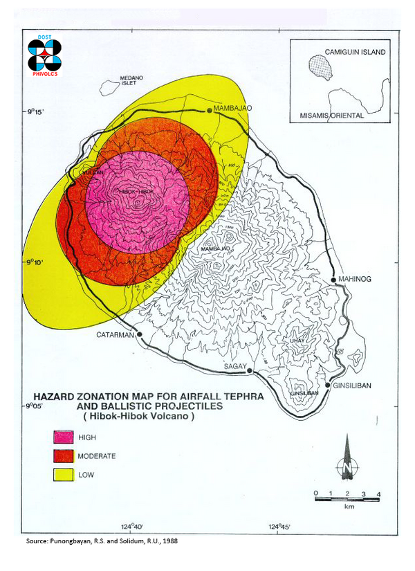
Official, Figure in hazard assessment
Hazard Zonation Map for Airfall Tephra and Ballistic Projectiles (Hibok-Hibok Volcano)
Punongbayan, R.S. & Solidum, R.U. (1988). Hazard Zonation Map for Airfall Tephra and Ballistic Projectiles (Hibok-Hibok Volcano). Philippine Institute of Volcanology and Seismology – Department of Science and Technology (PHIVOLCS-DOST).
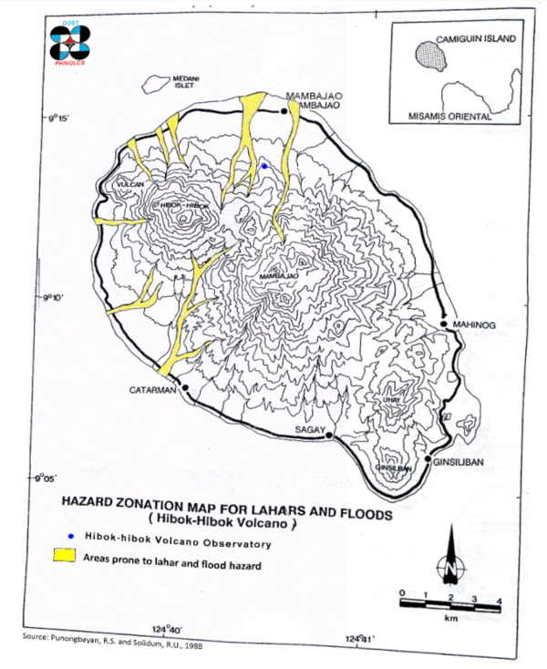
Official, Figure in hazard assessment
Hazard Zonation Map for Lahars and Floods (Hibok-Hibok Volcano)
Punongbayan, R.S. & Solidum, R.U. (1988). Hazard Zonation Map for Lahars and Floods (Hibok-Hibok Volcano). Philippine Institute of Volcanology and Seismology – Department of Science and Technology (PHIVOLCS-DOST).
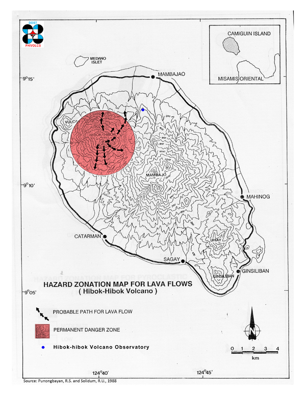
Official, Figure in hazard assessment
Hazard Zonation Map for Lava Flows (Hibok-Hibok Volcano)
Punongbayan, R.S. & Solidum, R.U. (1988). Hazard Zonation Map for Lava Flows (Hibok-Hibok Volcano). Philippine Institute of Volcanology and Seismology – Department of Science and Technology (PHIVOLCS-DOST).
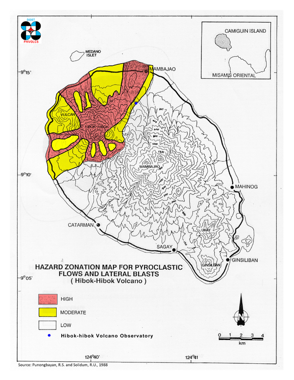
Official, Figure in hazard assessment
Hazard Zonation Map for Pyroclastic Flows and Lateral Blasts (Hibok-Hibok Volcano)
Punongbayan, R.S. & Solidum, R.U. (1988). Hazard Zonation Map for Pyroclastic Flows and Lateral Blasts (Hibok-Hibok Volcano). Philippine Institute of Volcanology and Seismology – Department of Science and Technology (PHIVOLCS-DOST).
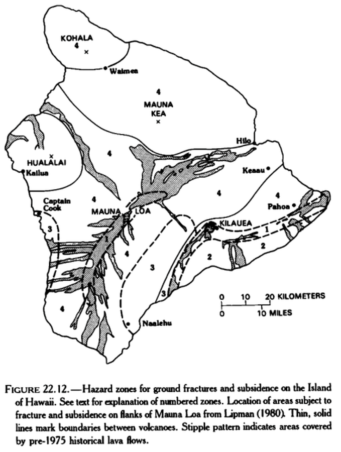
Official, Figure in hazard assessment
Hazard zones for ground fractures and subsidence on the Island of Hawaii
Figure 22.12 in: Mullineaux, D.R., Peterson, D.W., & Crandell, D.R. (1987). Volcanic hazards in the Hawaiian Islands. In: Decker, R.W., Wright, T.L., & Stauffer, P.H. (Eds.) Volcanism in Hawaii. US Geological Survey Professional Paper 1350, Chapter 22, p. 599-621. https://doi.org/10.3133/pp1350
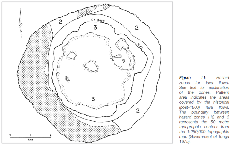
Official, Figure in hazard assessment
Hazard zones for lava flows
Figure 11 in: Taylor, P.W. (2016). Niuafo’ou, Tonga: Volcanic Hazards and the Risk From Future Activity. In: Taylor, P.W. (Ed.) Volcanic Hazards and Emergency Management in the Southwest Pacific, SPC Technical Bulletin, SPC00017, p. 132-150