
Advanced Search for Maps
Showing 41-50 of 240
Official, Map sheet or poster
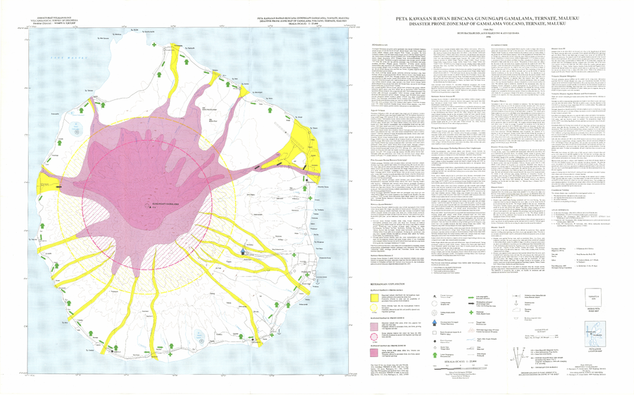
Disaster Prone Zone Map of Gamalama Volcano, Ternate, Maluku
Bacharudin, R., Martono, A., & Djuhara, A. (1996). Disaster Prone Zone Map of Gamalama Volcano, Ternate, Maluku. Volcanological Survey of Indonesia (VSI).
Official, Insert/poster-size map with accompanying report
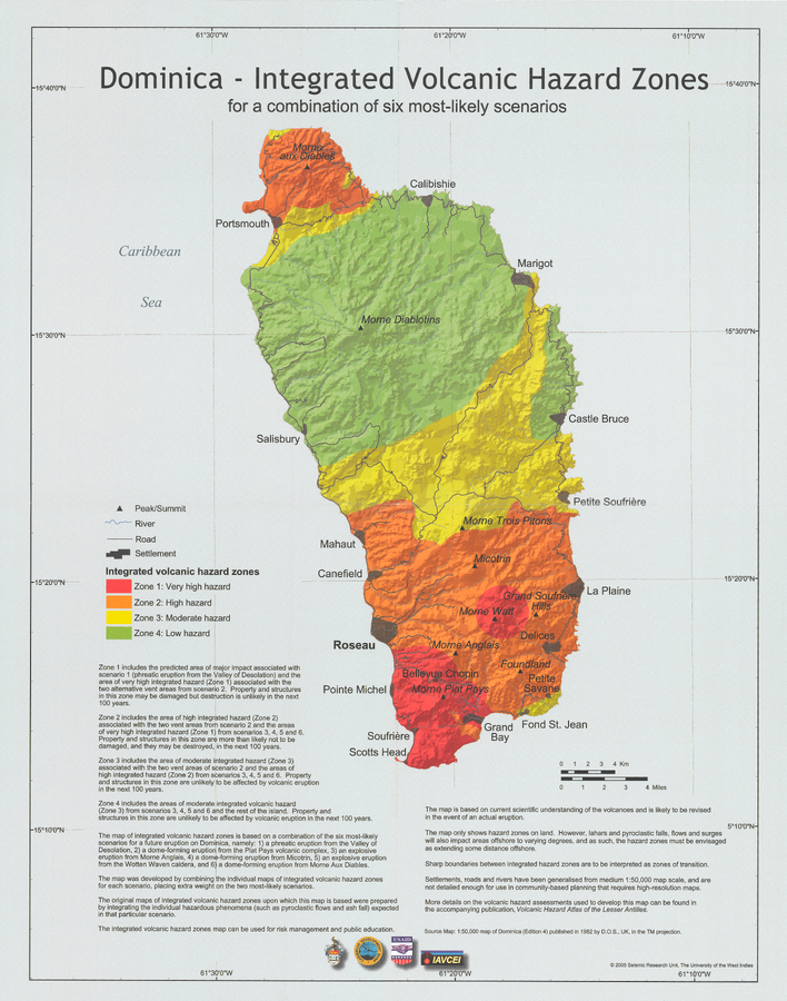
Dominica - Integrated Volcanic Hazard Zones for a combination of six most-likely scenarios
Pocket insert in: Lindsay, J.M., Smith, A.L., Roobol, M.J., & Stasiuk, M.V. (2005). Dominica. Volcanic hazard atlas of the Lesser Antilles. In: Lindsay, J.M., Shepherd, J.B., Robertson, R.E.A., & Ali, S. (Eds) Volcanic hazard atlas of the Lesser Antilles. Seismic Research Unit, The University of the West Indies, Trinidad and Tobago, W.I. p. 2-47
Official, Figure in hazard assessment
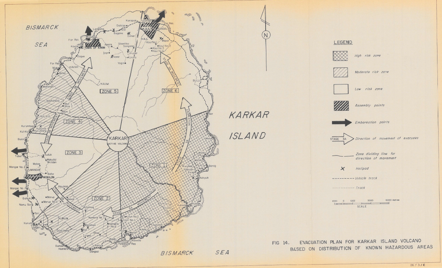
Evacuation Plan for Karkar Island Volcano Based on Distribution of Known Hazardous Areas
Figure 14 in: Lowenstein, P.L. (1982). Problems of volcanic hazards in Papua New Guinea. Geological Survey of Papua New Guinea, Report 82/7, 62 p.

Official, Figure in hazard assessment
Evaluation Quantitative De L'Aléa Volcanique Global (combinaison "intensite * fréquence)
(Quantitative Assessment of the Global Volcanic Hazard (combination "intensity * frequency))
Annex 4.9 in: Stieltjes, L. & Mirgon, C. (1998). Approche méthodologique de la vulnérabilité aux phénomènes volcaniques. Test d’application sur les réseaux de la Martinique. Rapport de synthese. Rapport Bureau de Recherches Géologiques et Minières (BRGM), Marseille, R 40098. http://infoterre.brgm.fr/rapports/RR-40098-FR.pdf
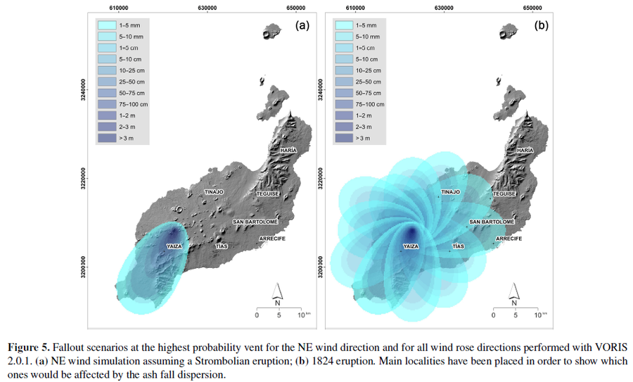
Figure in a journal article
Fallout scenarios at the highest probability vent for the NE wind direction and for all wind rose directions performed with VORIS 2.0.1
Figure 5 in: Becerril, L., Martí, J., Bartolini, S., & Geyer, A. (2017). Assessing qualitative long-term volcanic hazards at Lanzarote Island (Canary Islands). Natural Hazards and Earth System Sciences, 17(7), 1145-1157. https://doi.org/10.5194/nhess-17-1145-2017
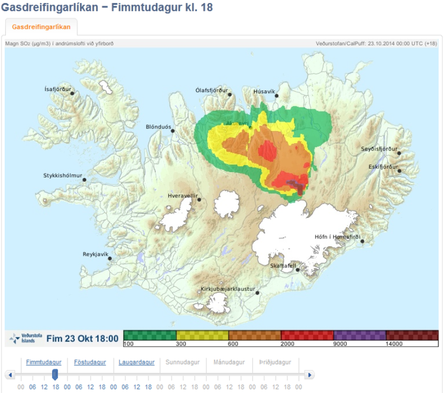
Official, Map in an information statement
Gasdreifingarspá. Magn SO2 í andrúmslofti við yfirborð. Fim 23 Okt 18:00
(Gas distribution forecast. Amount of SO2 in atmosphere at surface. Thu 23 Oct 18:00)
Iceland Meteorological Office (IMO). (2014). Gasdreifingarspá. Magn SO2 í andrúmslofti við yfirborð. Fim 23 Okt 18:00
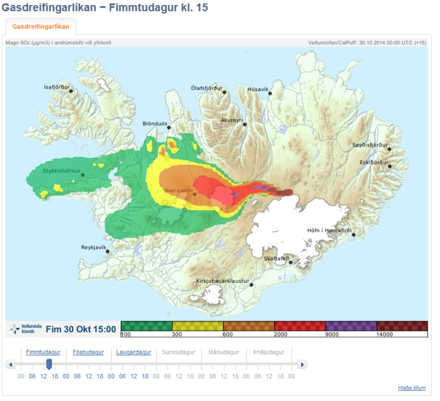
Official, Map in an information statement
Gasdreifingarspá. Magn SO2 í andrúmslofti við yfirborð. Fim 30 Okt 15:00
(Gasdreifingarspá. Amount of SO2 in atmosphere at surface. Thu Oct 30 15:00)
Iceland Meteorological Office (IMO). (2014). Gasdreifingarspá. Magn SO2 í andrúmslofti við yfirborð. Fim 30 Okt 15:00
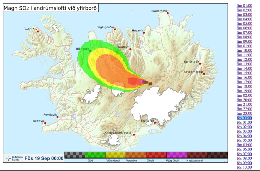
Official, Map in an information statement
Gasdreifingarspá. Magn SO2 í andrúmslofti við yfirborð. Fös 19 Sept 00:00
(Gas distribution forecast. Amount of SO2 in atmosphere at surface. Fri 19 Sept 00:00)
Iceland Meteorological Office (IMO). (2014). Gasdreifingarspá. Magn SO2 í andrúmslofti við yfirborð. Fös 19 Sept 00:00
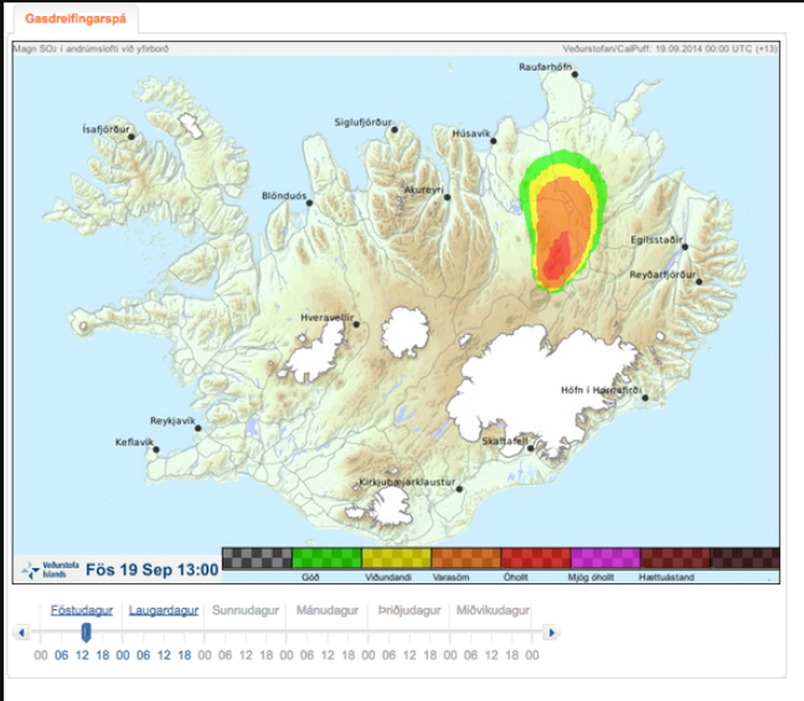
Official, Map in an information statement
Gasdreifingarspá. Magn SO2 í andrúmslofti við yfirborð. Fös 19 Sept 13:00
(Gas distribution forecast. Amount of SO2 in atmosphere at surface. Fri 19 Sept 13:00)
Iceland Meteorological Office (IMO). (2014). Gasdreifingarspá. Magn SO2 í andrúmslofti við yfirborð. Fös 19 Sept 13:00
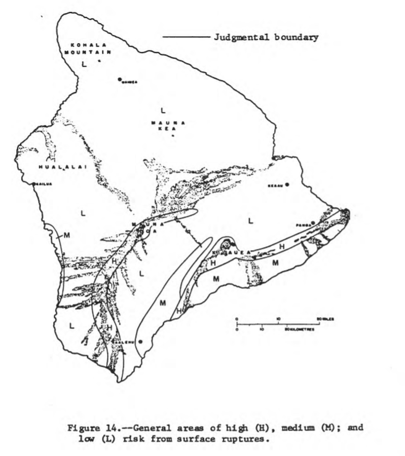
Official, Figure in hazard assessment
General areas of high (H), medium (M), and low (L) risk from surface ruptures
Figure 14 in: Mullineaux, D.R. & Peterson, D.W. (1974). Volcanic hazards on the Island of Hawaii. U.S. Geological Survey, Open-File Report 74-239. https://doi.org/10.3133/ofr74239