
Advanced Search for Maps
Showing 11-20 of 26
Official, Map sheet or poster
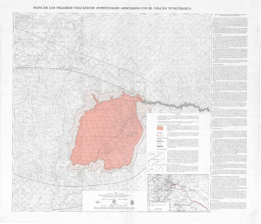
Mapa de los peligros volcánicos potenciales asociados con el Volcán Tungurahua
(Map of the potential volcanic hazards associated with the Tungurahua volcano)
Hall, M.L., Beate, B., & von Hillebrandt, C.G. (1988). Mapa de los peligros volcánicos potenciales asociados con el volcán Tungurahua. Escala 1:50,000. Instituto Geofísico, Escuela Politécnica Nacional (IG-EPN), Quito, 1ra Edición.
Official, Map sheet or poster
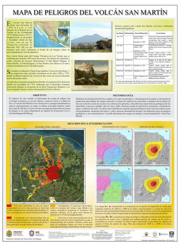
Mapa de Peligros del Volcán San Martín
(San Martín Volcano Hazard Map)
Sieron, K., Rodríguez Elizarraráz, S., Córdoba Montiel, F., Alarcón Ferreira, A.M., & Mora González, I. (2018). Mapa de Peligros del Volcán San Martín. Centro de Ciencias de la Tierra, UV & Instituto de Geofísica, UNAM
Official, Interactive web-based map
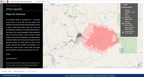
Mapa Interactivo del Volcán Cayambe
(Cayambe Volcano Interactive Map)
Instituto Geofísico de la Escuela Politecnica Nacional (IG-EPN). (2019). Mapa Interactivo del Volcán Cayambe.
Official, Map sheet or poster
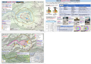
Midagahara Volcanic Hazard Map
Midagahara Volcano Disaster Prevention Council. (2018). Midagahara Volcanic Hazard Map. Toyama Prefecture Disaster Prevention Crisis and Science Division.
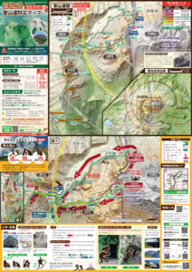
Official, Map sheet or poster
Mt. Unzen-dake Trail Volcanic Disaster Prevention Map
Volcano Disaster Management Councils of Mt. Unzen. (2018). Mt.Unzen-dake Trail Volcanic Disaster Prevention Map.
Official, Interactive web-based map
Nanae Town Eruption/Earthquake [Interactive Map]
Nanae Town. (2022). Nanae Town Eruption/Earthquake [Interactive Map]. http://www2.town.nanae.hokkaido.jp/bousai/hazardmap/map.html?lay=funka
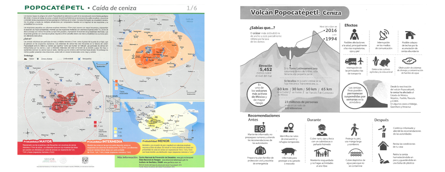
Official, Flyer, brochure, short fact-sheet, or handout
Popocatépetl - Caída de ceniza
(Popocatépetl - Ash fall)
Map 1 in: Instituto de Geofísica Universidad Nacional Autónoma de México (IG-UNAM), Centro Nacional de Prevención de Desastres (CENAPRED), Secretaría de Gobernación (SEGOB). (2016). Popocatépetl - Caída de ceniza. Gobierno de México. (Simplified from: Martin Del Pozzo et al. 2016)
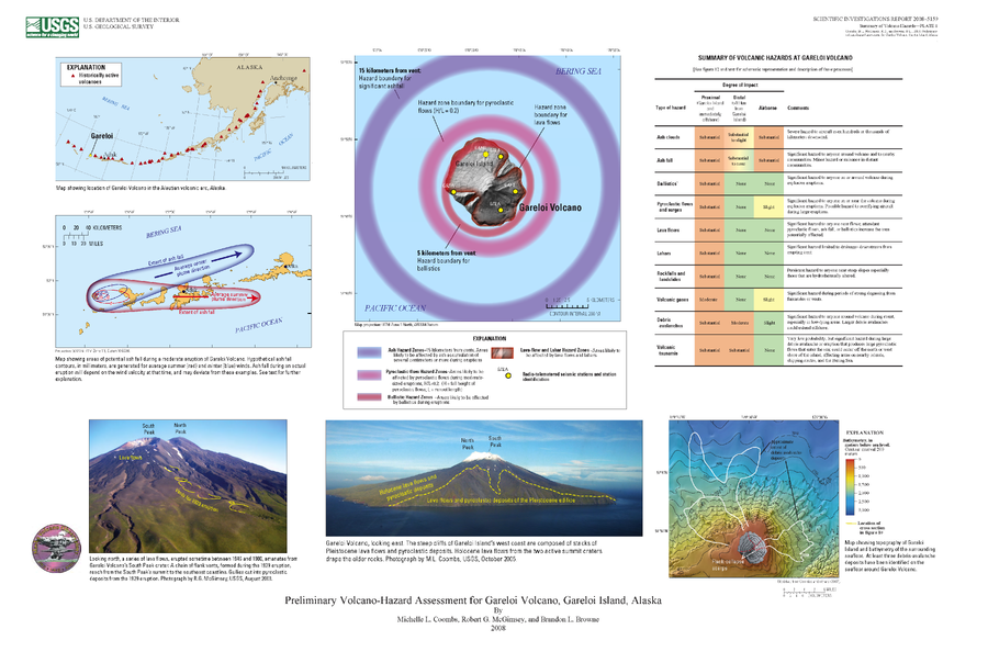
Official, Insert/poster-size map with accompanying report
Preliminary Volcano-Hazard Assessment for Gareloi Volcano, Gareloi Island, Alaska
Plate 1 in: Coombs, M.L., McGimsey, R.G. & Browne, B.L. (2008). Preliminary volcano-hazard assessment for Gareloi Volcano, Gareloi Island, Alaska. U.S. Geological Survey, Scientific Investigations Report 2008–5159, 27 p., 1 plate.
Official, Insert/poster-size map with accompanying report
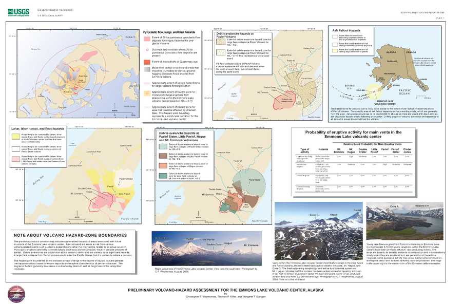
Preliminary Volcano-Hazard Assessment for the Emmons Lake Volcanic Center, Alaska
Plate 1 in: Waythomas, C.F., Miller, T.P. & Mangan, M.T. (2006). Preliminary volcano hazard assessment for the Emmons Lake Volcanic Center, Alaska. U.S. Geological Survey, Scientific Investigations Report 2006-5248, 33 p. https://doi.org/10.3133/sir20065248

Official, Figure on website
Tephra fall probabilities based on 10 historical Grímsvötn eruptions
Guðmundsson, M.T. & Larsen, G. (2019). Grímsvötn. In: Oladottir, B., Larsen, G. & Guðmundsson, M. T. Catalogue of Icelandic Volcanoes. Iceland Meteorological Office (IMO), Univeristy of Iceland, and Civil Protection Department of the National Commissioner of the Iceland Police (CPD-NCIP). https://icelandicvolcanos.is//index.html (Simplified from: Thorarinsson 1974, Gudmundsson et al. 2004, Oddsson et al. 2012, Gudmundsson et al. 2013)