
Advanced Search for Maps
Showing 11-20 of 75
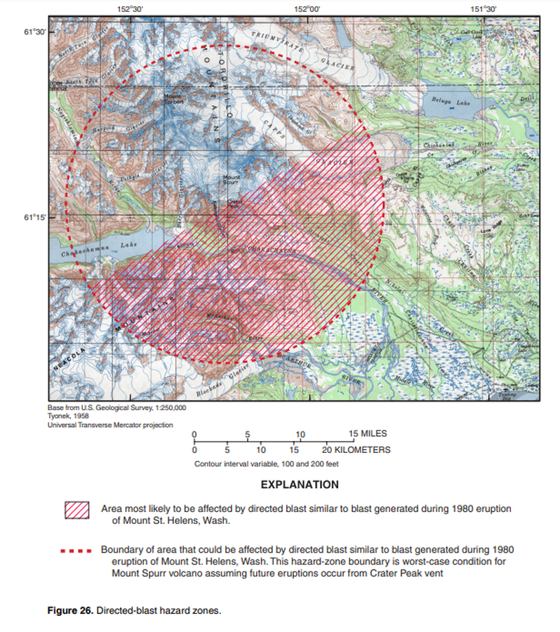
Official, Figure in hazard assessment
Directed-blast hazard zones
Figure 26 in: Waythomas, C.F. & Nye, C.J. (2002). Preliminary volcano-hazard assessment for Mount Spurr Volcano, Alaska. U.S. Geological Survey, Open-File Report 2001-482, 40 p., 1 plate. https://doi.org/10.3133/ofr01482
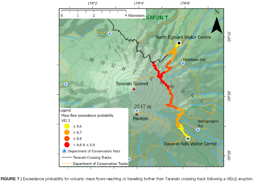
Figure in a journal article
Exceedance probability for volcanic mass flows reaching or travelling further than Taranaki crossing track following a VEI≤2 eruption
Figure 7 in: Mead, S., Procter, J., Bebbington, M., & Rodriguez-Gomez, C. (2022). Probabilistic Volcanic Hazard Assessment for National Park Infrastructure Proximal to Taranaki Volcano (New Zealand). Frontiers in Earth Science, 435. https://doi.org/10.3389/feart.2022.832531
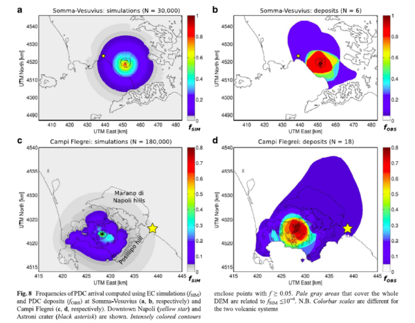
Figure in a journal article
Frequencies of PDC arrival computed using EC simulations and PDC deposits at Somma-Vesuvius and Campi Flegrei
Figure 8c-d in: Tierz, P., Sandri, L., Costa, A., Zaccarelli, L., Di Vito, M. A., Sulpizio, R., & Marzocchi, W. (2016). Suitability of energy cone for probabilistic volcanic hazard assessment: validation tests at Somma-Vesuvius and Campi Flegrei (Italy). Bulletin of Volcanology, 78(11). https://doi.org/10.1007/s00445-016-1073-9
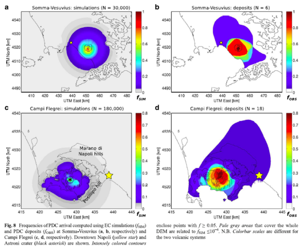
Figure in a journal article
Frequencies of PDC arrival computed using EC simulations and PDC deposits at Somma-Vesuvius and Campi Flegrei
Figure 8a-b in: Tierz, P., Sandri, L., Costa, A., Zaccarelli, L., Di Vito, M. A., Sulpizio, R., & Marzocchi, W. (2016). Suitability of energy cone for probabilistic volcanic hazard assessment: validation tests at Somma-Vesuvius and Campi Flegrei (Italy). Bulletin of Volcanology, 78(11). https://doi.org/10.1007/s00445-016-1073-9
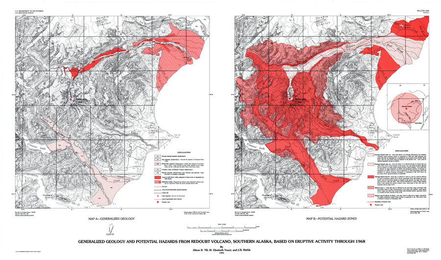
Official, Insert/poster-size map with accompanying report
Generalized Geology and Potential Hazards from Redoubt Volcano, Southern Alaska, Based on Eruptive Activity Through 1968
Plate 1 in: Till, A.B., Yount, M.E., & Riehle, J.R. (1993). Redoubt Volcano, southern Alaska; a hazard assessment based on eruptive activity through 1968. U.S. Geological Survey, Bulletin 1996, 19 p., 1 plate. https://doi.org/10.3133/b1996
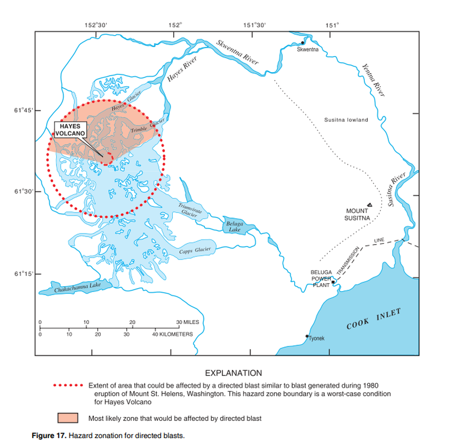
Official, Figure in hazard assessment
Hazard zonation for directed blasts
Figure 17 in: Waythomas, C.F. & Miller, T.P. (2002). Preliminary volcano-hazard assessment for Hayes Volcano, Alaska. U.S. Geological Survey, Open-File Report 02-072, 33 p., 1 plate. https://doi.org/10.3133/ofr0272
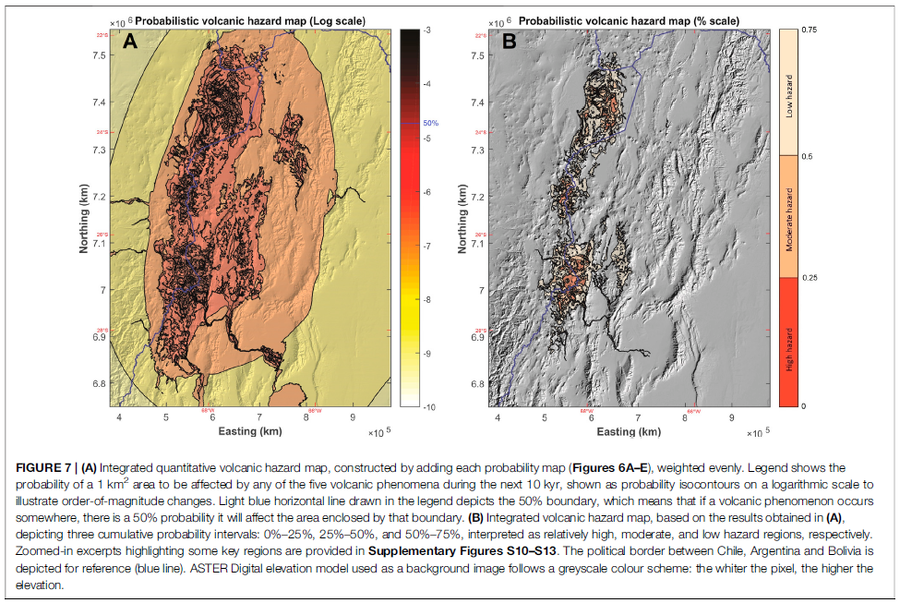
Figure in a journal article
Integrated quantitative volcanic hazard map, constructed by adding each probability map (Figures 6A–E), weighted evenly
Figure 7 in: Bertin, D., Lindsay, J.M., Cronin, S.J., de Silva, S.L., Connor, C.B., Caffe, P.J., Grosse, P., Báez, W., Bustos, E., & Constantinescu, R. (2022). Probabilistic Volcanic Hazard Assessment of the 22.5–28° S Segment of the Central Volcanic Zone of the Andes. Frontiers in Earth Science, 10. https://doi.org/10.3389/feart.2022.875439
Makushin, United States
Official, Figure in hazard assessment
Lateral blast hazard zone at Makushin Volcano, assuming the extent of a future blast is comparable to that at Mount St. Helens in 1980
Figure 13 in: Beget, J.E., Nye, C.J. & Bean, K.W. (2000). Preliminary volcano-hazard assessment for Makushin Volcano, Alaska. Alaska Division of Geological & Geophysical Surveys, Report of Investigation 2000-4, 22 p., 1 sheet, scale 1:100,000.
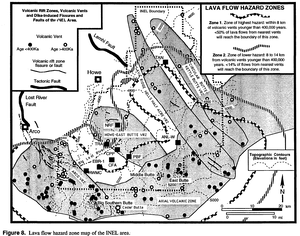
Official, Figure in hazard assessment
Lava flow hazard zone map of the INEL area
Figure 8 in: Hackett, W.R. & Smith, R.P. (1994). Volcanic hazards of the Idaho National Engineering Laboratory and adjacent areas (No. INEL--94/0276). Lockheed Martin Idaho Technologies Co..
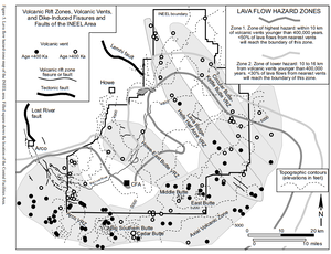
Official, Figure in hazard assessment
Lava Flow Hazard Zones
Figure 5 in: Hackett, W.R., Smith, R.P., & Khericha, S. (2002). Volcanic hazards of the Idaho National Engineering and Environmental Laboratory, southeast Idaho. In: Bonnichsen, B., White, C.M., and McCurry, M. (eds.). Tectonic and Magmatic Evolution of the Snake River Plain Volcanic Province. Idaho Geological Survey Bulletin 30, p. 461-482.