
Advanced Search for Maps
Showing 31-40 of 75
Official, Figure in hazard assessment
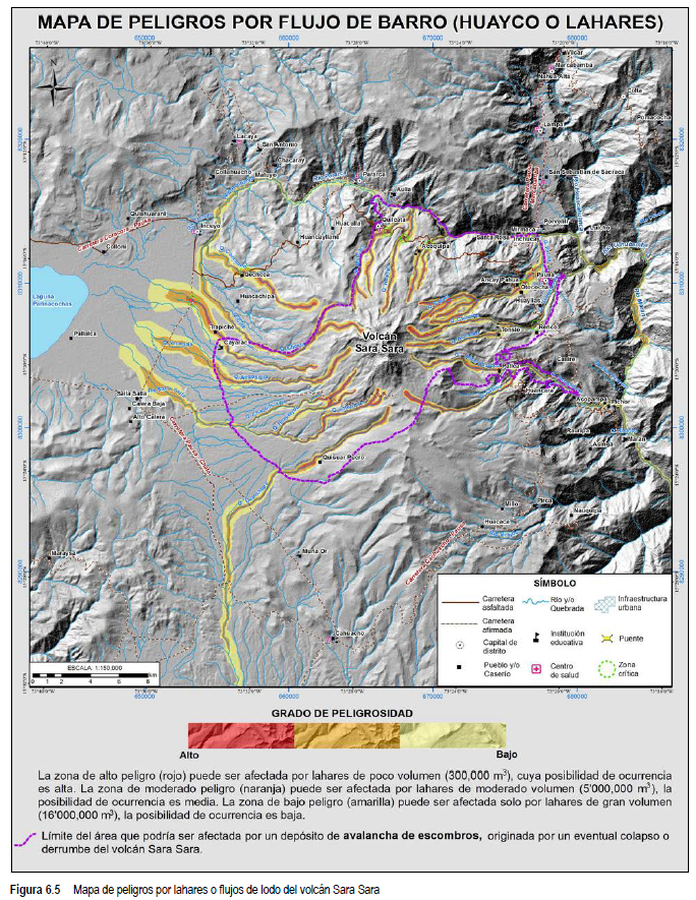
Mapa de Peligros por Flujo de Barro (Huayco o Lahares)
(Mudflow Hazard Map (Huayco or Lahars))
Figure 6.5 in: Rivera, M., Cueva, K., Le Pennec, J.-L., Vela, J., Samaniego, P., Manrique, N. & Soncco, Y. (2020). Geología y evaluación de peligros del volcán Sara Sara (Ayacucho). INGEMMET, Boletín, Serie C: Geodinámica e Ingeniería Geológica, 78, 154 p., 2 mapas.
Official, Figure in hazard assessment
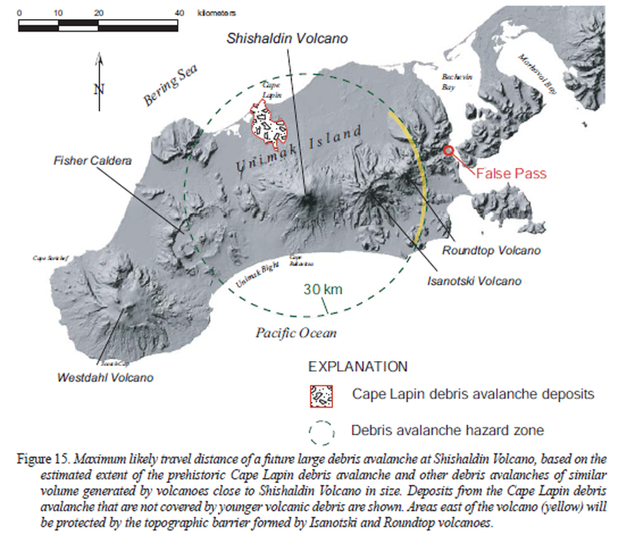
Maximum likely travel distance of a future large debris avalanche at Shishaldin Volcano
Figure 15 in: Beget, J.E., Nye, C.J., Schaefer, J.R. & Stelling, P.L. (2003). Preliminary volcano-hazard assessment for Shishaldin Volcano, Alaska. Alaska Division of Geological & Geophysical Surveys, Report of Investigations 2002-4, 28 p., 1 sheet, scale 1:500,000. http://doi.org/10.14509/2872
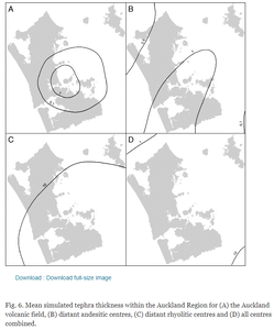
Figure in a journal article
Mean simulated tephra thickness within the Auckland Region
Figure 6 in: Magill, C. R., Hurst, A. W., Hunter, L. J., & Blong, R. J. (2006). Probabilistic tephra fall simulation for the Auckland Region, New Zealand. Journal of volcanology and geothermal research, 153(3-4), 370-386. https://doi.org/10.1016/j.jvolgeores.2005.12.002
Official, Map sheet or poster
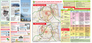
Mt. Tsurumi, Mt. Garan Volcano Disaster Prevention Guide (for mountain climbers and tourists)
Tsurumidake & Garandake Volcano Disaster Prevention Council. (2016). Tsurumidake and Garandake Volcano Disaster Prevention Map (for mountain climbers and tourists). Beppu City, Yufu City, Usa City, Hiji Town, and Oita Prefecture.
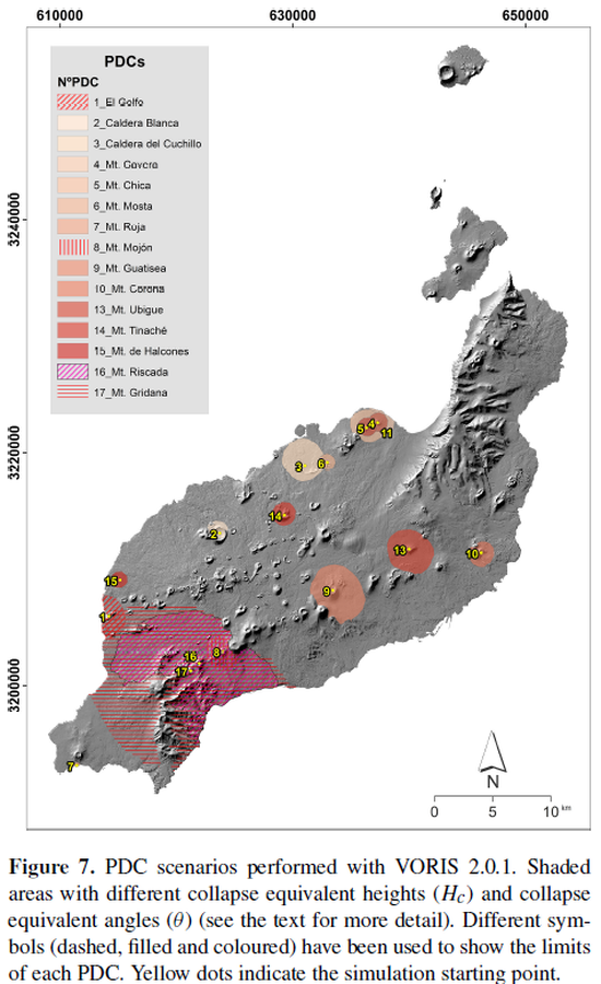
Figure in a journal article
PDC scenarios performed with VORIS 2.0.1
Figure 7 in: Becerril, L., Martí, J., Bartolini, S., & Geyer, A. (2017). Assessing qualitative long-term volcanic hazards at Lanzarote Island (Canary Islands). Natural Hazards and Earth System Sciences, 17(7), 1145-1157. https://doi.org/10.5194/nhess-17-1145-2017
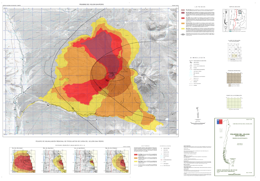
Official, Map sheet or poster
Peligros del Volcán San Pedro
(San Pedro Volcano Hazards)
Bertin, D. & Amigo, A. (2015). Peligros del volcán San Pedro, Región de Antofagasta. Servicio Nacional de Geología y Minería, Carta Geológica de Chile, Serie Geología Ambiente, No., p., 1, mapa escala 1:50.000. Santiago.
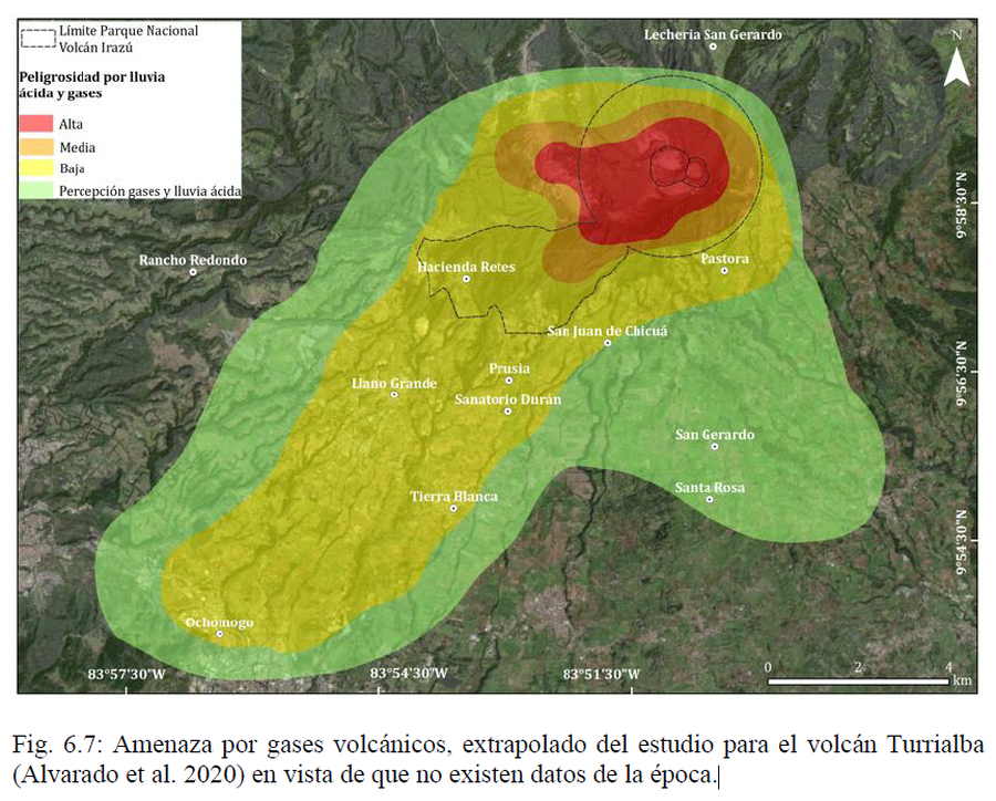
Official, Figure in hazard assessment
Peligrosidad por lluvia ácida y gases
(Danger due to acid rain and gases)
Figure 6.7 in: Alvarado, G.E., Campos-Durán, D., Brenes-André, J., Alpízar, Y., Núñez, S., Esquivel, L., Sibaja, J.P. & Fallas, B. (2021). Peligro Volcánico del Irazú, Costa Rica. Comisión Nacional de Prevención de Riesgos y Atención de Emergencias (CNE). Deciembre 2021.
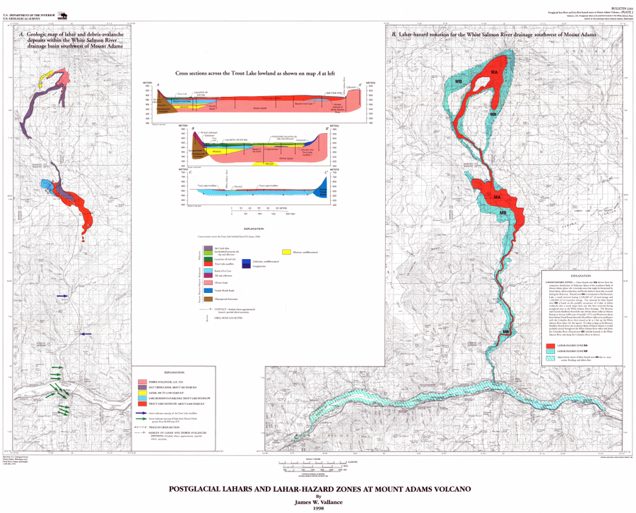
Official, Insert/poster-size map with accompanying report
Postglacial Lahars and Lahar-Hazard Zones at Mount Adams Volcano
Plate 2 in: Vallance, J.W. (1999). Postglacial lahars and potential hazards in the White Salmon River system on the southwest flank of Mount Adams, Washington. U.S. Geological Survey, Bulletin 2161, 49 p., 2 plates. https://doi.org/10.3133/b2161
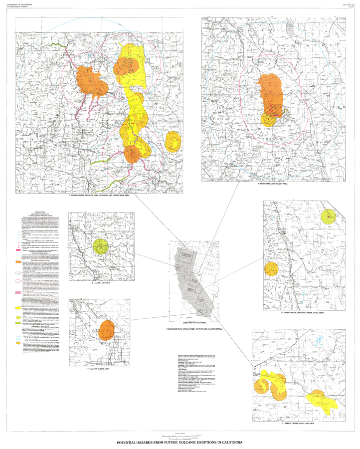
Official, Insert/poster-size map with accompanying report
Potential Hazards from future volcanic eruptions in California
Plate 1 in: Miller, C.D. (1989). Potential hazards from future volcanic eruptions in California. U.S. Geological Survey, Bulletin 1847, 17 p., 2 tables, 1 plate, scale 1:500,000.
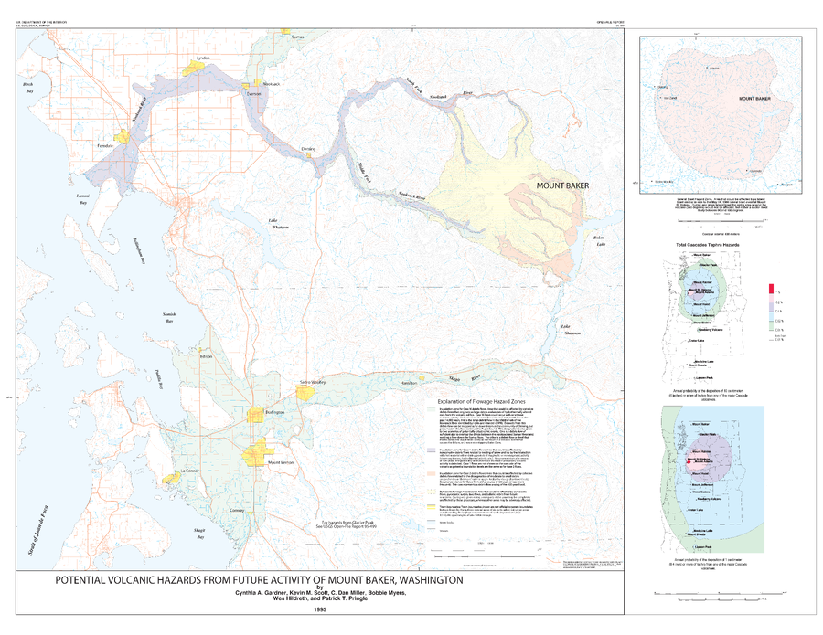
Official, Insert/poster-size map with accompanying report
Potential Volcanic Hazards from Future Activity of Mount Baker, Washington
Plate 1 in: Gardner, C.A., Scott, K.M., Miller, C.D., Myers, B., Hildreth, W., & Pringle, P.T. (1995). Potential volcanic hazards from future activity of Mount Baker, Washington. U.S. Geological Survey, Open-File Report 95-498, 16 p., 1 plate, scale 1:100,000. https://doi.org/10.3133/ofr95498