
Advanced Search for Maps
Showing 51-60 of 75
Official, Map in a booklet, long fact-sheet, or handbook
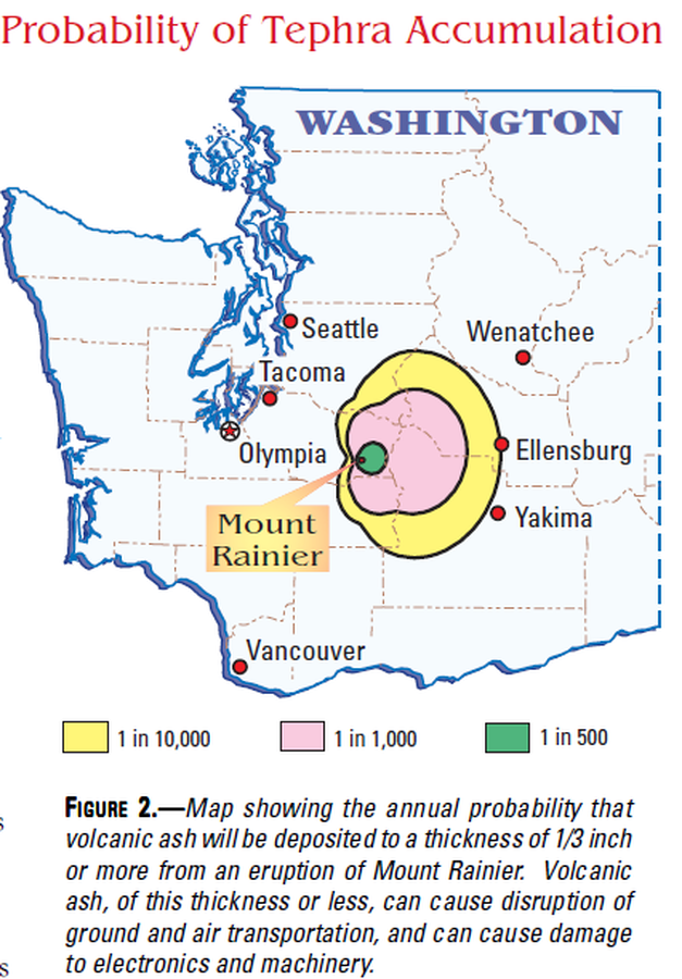
Probability of Tephra Accumulation
Figure 2 in: Driedger, C.L. & Scott, K.M. (2002). Mount Rainier: learning to live with volcanic risk. U.S. Geological Survey, Fact Sheet 034-02, 4 p. https://doi.org/10.3133/fs03402
Official, Figure on website
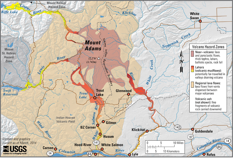
Simplified volcano hazards map of Mount Adams, Washington
Scott, W.E., Iverson, R., Vallance, J.W., Hildreth, W., Driedger, C.L., Ramsey, D.W., & Faust, L.M. (2014). Simplified volcano hazards map of Mount Adams, Washington. U.S. Geological Survey. Mount Adams, WA Simplified Hazards Map. https://www.usgs.gov/media/images/mount-adams-wa-simplified-hazards-map (Modified from: U.S. Geological Survey, Open-File Report 95-492)
Official, Figure on website
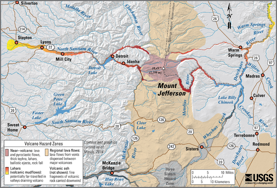
Simplified volcano hazards map of Mount Jefferson, Oregon
Walder, J.S., Gardner, C., Conrey, R.M., Fisher, B.J., Schilling, S.P., Driedger, C.L., Scott, W.E., Iverson, R.M., Ramsey, D.W., & Faust, L.M. (2014). Simplified volcano hazards map of Mount Jefferson, Oregon. U.S. Geological Survey. Mount Jefferson, OR Simplified Hazards Map. https://www.usgs.gov/media/images/mount-jefferson-or-simplified-hazards-map (Modified from: U.S. Geological Survey, Open-File Report 99-24)
Official, Figure on website
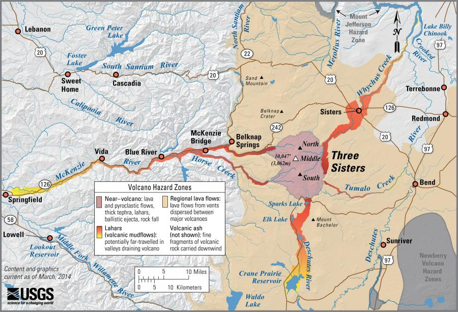
Simplified volcano hazards map of Three Sisters, Oregon
Scott, W.E., Iverson, R.M., Schilling, S.P., Fisher, B.J., Driedger, C.L., Ramsey, D.W., & Faust, L.M. (2014). Simplified volcano hazards map of Three Sisters, Oregon. U.S. Geological Survey. Three Sisters, OR Simplified Hazards Map. https://www.usgs.gov/media/images/three-sisters-or-simplified-hazards-map (Modified from: U.S. Geological Survey, Open-File Report 99-437)
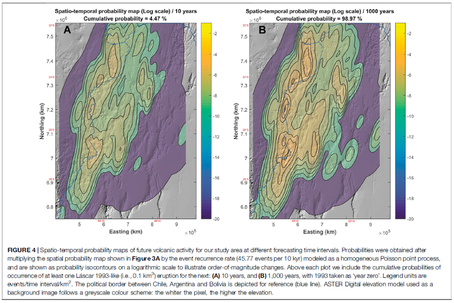
Figure in a journal article
Spatio-temporal probability maps of future volcanic activity for our study area at different forecasting time intervals
Figure 4 in: Bertin, D., Lindsay, J.M., Cronin, S.J., de Silva, S.L., Connor, C.B., Caffe, P.J., Grosse, P., Báez, W., Bustos, E., & Constantinescu, R. (2022). Probabilistic Volcanic Hazard Assessment of the 22.5–28° S Segment of the Central Volcanic Zone of the Andes. Frontiers in Earth Science, 10. https://doi.org/10.3389/feart.2022.875439
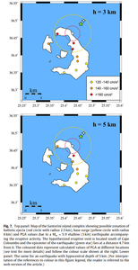
Figure in a journal article
Top panel: Map of the Santorini island complex showing possible zonation of ballistic ejecta (red circle with radius 2.5 km), base surge (yellow circle with radius 6 km) and PGA values due to a Mw =5.9 shallow (3 km) earthquake accompanying the eruptive activity...Lower panel: The same for an earthquake with hypocentral depth of 5 km
Figure 7 in: Konstantinou, K.I. & Yeh, T.Y. (2012). Stress field around the Coloumbo magma chamber, southern Aegean: Its significance for assessing volcanic and seismic hazard in Santorini. Journal of Geodynamics, 54, 13-20. https://doi.org/10.1016/j.jog.2011.09.003
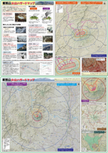
Official, Map sheet or poster
Tsurumidake and Garandake volcano disaster prevention map
Tsurumidake & Gayandake Volcano Disaster Prevention Council. (2015). Tsurumidake and Garandake volcano disaster prevention map. Beppu City, Yufu City, Usa City, Hiji Town, and Oita Prefecture.
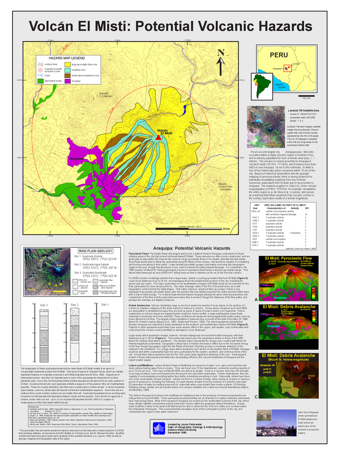
Figure in a thesis or dissertation
Volcán El Misti: Potential Volcanic Hazards
Permenter, J.L. (1999). A Preliminary Volcanic Hazard Assessment for the Arequipa Region, Southern Peru. MS Thesis. Department of Geography, Geology, and Anthropology, Indiana State University, Terre Haute, Indiana.
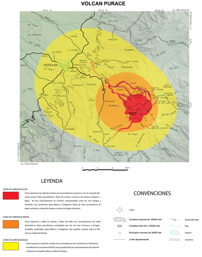
Official, Insert/poster-size map with accompanying report
Volcan Purace
(Purace Volcano)
Monsalve, M.L. & Pulgarin, B.A. (1993). Mapa Preliminar de Amenaza Volcanica Potencial del Volcan Purace. Revista Instituto Colombiano de Geología y Minería (INGEOMINAS), 2
Official, Map sheet or poster
Volcanic disaster prevention map of Kurikomayama volcano
Volcano Disaster Management Councils of Kurikomayama volcano. (2018). Volcanic disaster prevention map of Kurikomayama volcano. Iwate Prefecture, Miyagi Prefecture, Akita Prefecture, Ichinoseki City, kurihara City, Yokote City, Yuzawa City, Ugo Town, Higashinaruse.