
Advanced Search for Maps
Showing 21-30 of 75
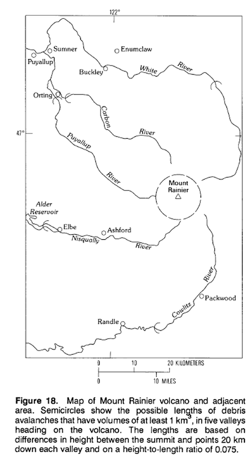
Official, Figure in hazard assessment
Map of Mount Rainier volcano and adjacent area.
Figure 18 in: Crandell, D.R. (1989). Gigantic debris avalanche of Pleistocene age from ancestral Mount Shasta Volcano, California, and debris-avalanche hazard zonation. U.S. Geological Survey, Bulletin 1861, 32 p. https://doi.org/10.3133/b1861
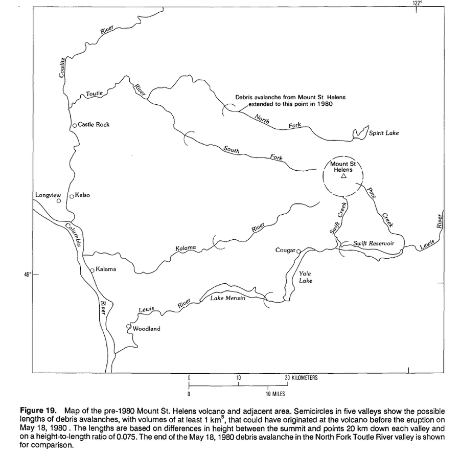
Official, Figure in hazard assessment
Map of pre-1980 Mount St. Helens volcano and adjacent area.
Figure 19 in: Crandell, D.R. (1989). Gigantic debris avalanche of Pleistocene age from ancestral Mount Shasta Volcano, California, and debris-avalanche hazard zonation. U.S. Geological Survey, Bulletin 1861, 32 p. https://doi.org/10.3133/b1861
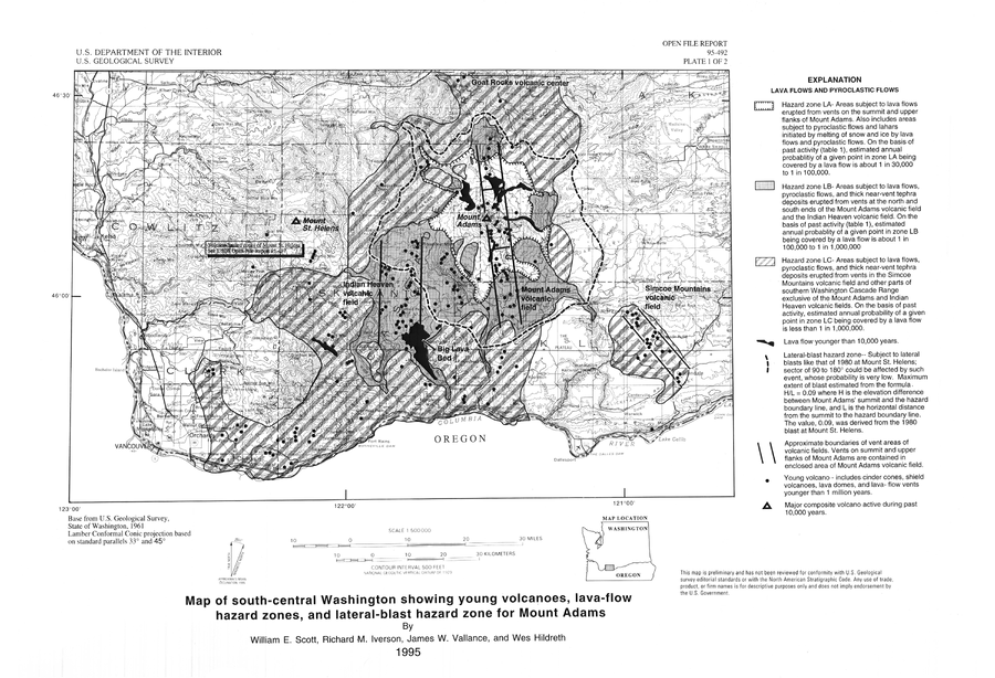
Official, Insert/poster-size map with accompanying report
Map of south-central Washington showing young volcanoes, lava-flow hazard zones, and lateral-blast hazard zone for Mount Adams
Plate 1 in: Scott, W.E., Iverson, R.M., Vallance, J.W., & Hildreth, W. (1995). Volcano Hazards in the Mount Adams Region, Washington. U.S. Geological Survey, Open-File Report 95-492. https://doi.org/10.3133/ofr95492
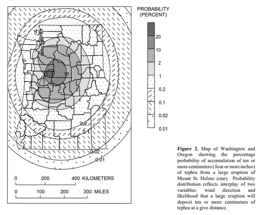
Official, Figure in hazard assessment
Map of Washington and Oregon showing the percentage probability of accumulation of ten or more centimeters (four or more inches) of tephra from a large eruptions of Mount St. Helens.
Figure 2 in: Wolfe, E.W. & Pierson, T.C. (1995). Volcanic-Hazard Zonation for Mount St. Helens, Washington, 1995. U.S. Geological Survey, Open-File Report 95-497, 12 p., 1 plate. https://doi.org/10.3133/ofr95497
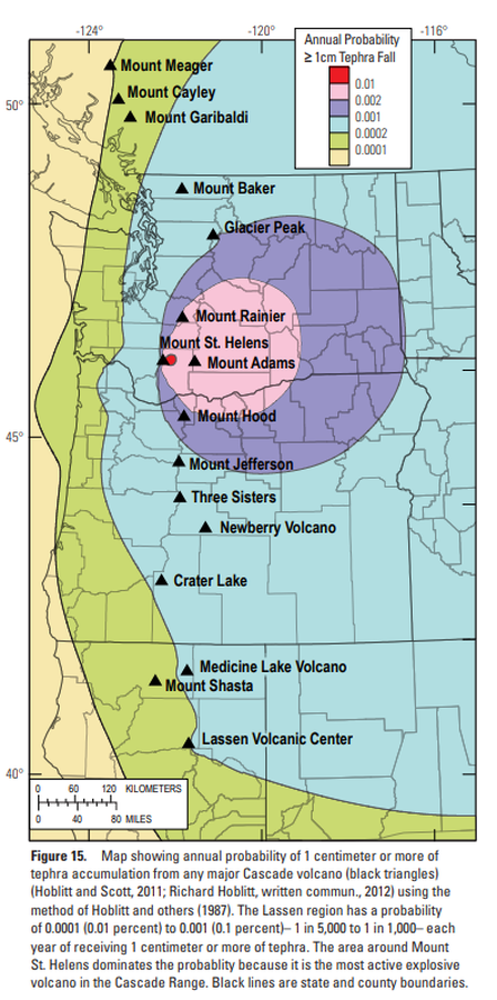
Official, Figure in hazard assessment
Map showing annual probability of 1 centimeter or more of tephra accumulation from any major Cascade volcano
Figure 15 in: Clynne, M. A., Robinson, J. E., Nathenson, M. & Muffler, L. P. (2012). Volcano hazards assessment for the Lassen region, northern California. U.S. Geological Survey, Scientific Investigations Report 2012-5176-A, 47 p., 1 plate. https://doi.org/10.3133/sir20125176A
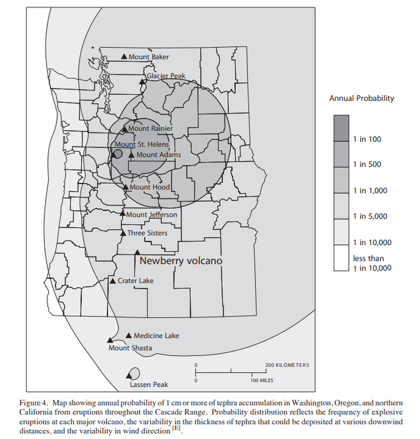
Official, Figure in hazard assessment
Map showing annual probability of 1 cm or more of tephra accumulation in Washington, Oregon, and northern California from eruptions throughout the Cascade Range.
Figure 4 in: Sherrod, D.R., Mastin, L.G., Scott, W.E. & Schilling, S.P. (1997). Volcano hazards at Newberry Volcano, Oregon. U.S. Geological Survey, Open-File Report 97-513, 14 p. https://doi.org/10.3133/ofr97513
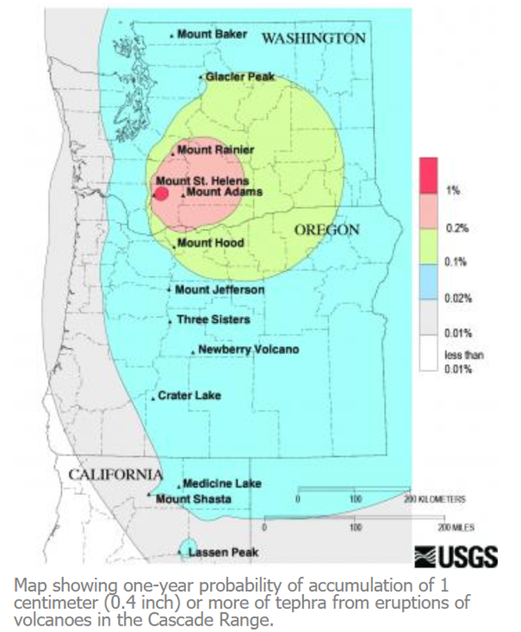
Official, Figure on website
Map showing one-year probability of accumulation of 1 centimeter (0.4 inch) or more of tephra from eruptions of volcanoes in the Cascade Range.
Nathensen, M. (2013). Map showing one-year probability of accumulation of 1 centimeter (0.4 inch) or more of tephra from eruptions of volcanoes in the Cascade Range. U.S. Geological Survey. Mount Bachelor Hazards. https://www.usgs.gov/volcanoes/mount-bachelor/hazards

Official, Insert/poster-size map with accompanying report
Mapa de Amenaza Volcánica del Volcán Sotará - Primera versión 2019
(Volcanic Hazard Map of the Sotara Volcano - First version 2019)
Servicio Geológico Colombiano (SGC). (2019). Mapa de Amenaza Volcánica del Volcán Sotará. Primera versión.
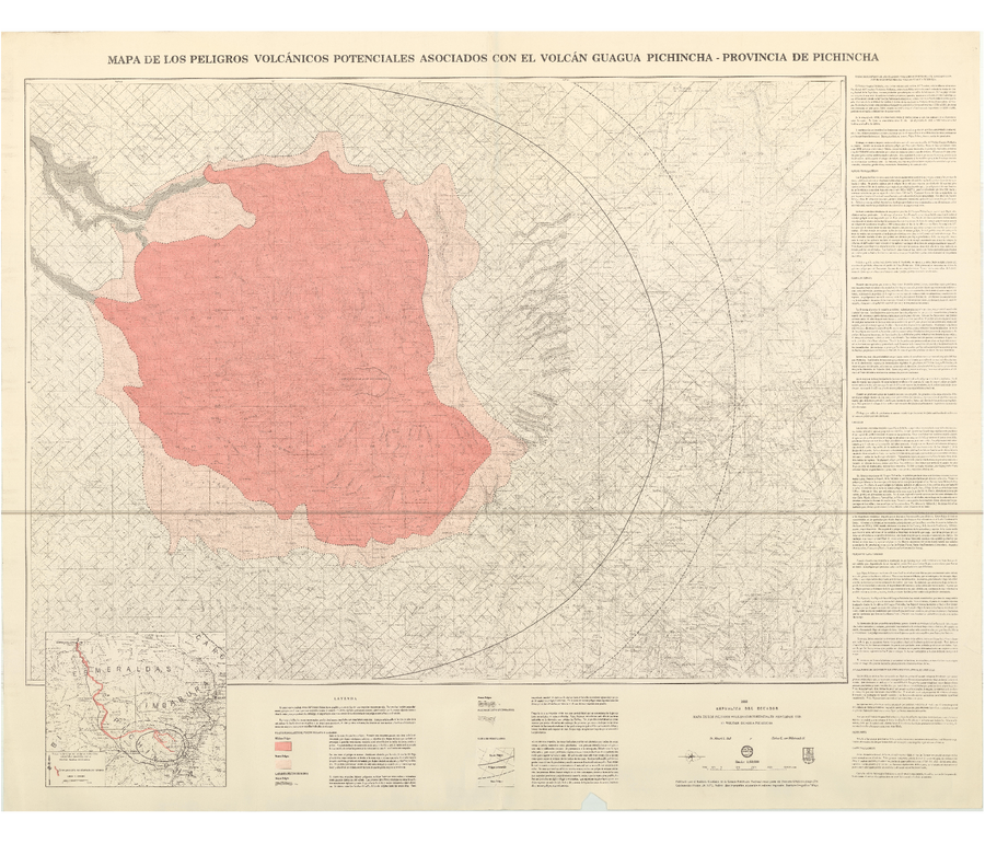
Official, Map sheet or poster
Mapa de los Peligros Volcánicos Asociados con el Volcán Guagua Pichincha - Provincia de Pichincha
(Map of Volcanic Hazards Associated with the Guagua Pichincha Volcano - Pichincha Province)
Hall, M.L. and von Hillebrandt, C.G. (1988). Mapa de los Peligros Volcánicos Asociados con el Volcán Guagua Pichincha - Provincia de Pichincha. Intituto Geofísico de la Escuela Politécnica Nacional (IG-EPN).
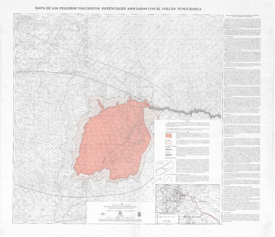
Official, Map sheet or poster
Mapa de los peligros volcánicos potenciales asociados con el Volcán Tungurahua
(Map of the potential volcanic hazards associated with the Tungurahua volcano)
Hall, M.L., Beate, B., & von Hillebrandt, C.G. (1988). Mapa de los peligros volcánicos potenciales asociados con el volcán Tungurahua. Escala 1:50,000. Instituto Geofísico, Escuela Politécnica Nacional (IG-EPN), Quito, 1ra Edición.