
Advanced Search for Maps
Showing 41-50 of 68
Official, Map sheet or poster
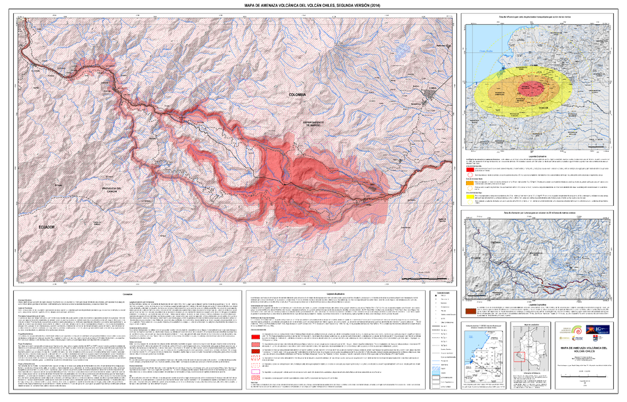
Mapa de Amenaza Volcánica del Volcán Chiles, Segunda Versión (2014)
(Volcanic Hazard Map of Chiles Volcano, Second Edition (2014))
Servicio Geológico Colombiano (SGC). (2014). Mapa de Amenaza Volcánica del Volcán Chiles, Sugunda Versión. escala 1:50,000.
Official, Map sheet or poster
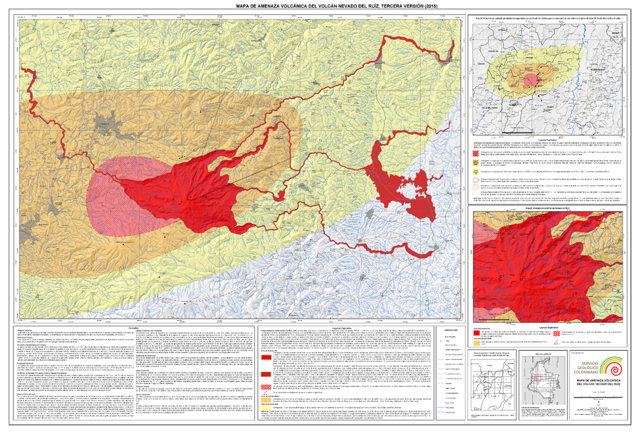
Mapa de Amenaza Volcánica del Volcán Nevado del Ruiz, Tercera Versión (2015)
(Volcanic Hazard Map of Nevado del Ruiz Volcano, Third Version (2015))
Servicio Geológico Colombiano (SGC). (2015). Mapa de Amenaza Volcánica del Volcán Nevado del Ruiz, Tercera Version. mapa escala 1:120,000. Bogota.
Official, Map sheet or poster
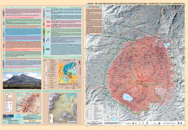
Mapa de los Peligros Volcánicos Potenciales del Complejo Volcánico Imbabura
(Map of the Potential Volcanic Hazards of the Imbabura Volcanic Complex)
Ruiz, A.G., Le Pennec, J.-L., Hall, M.L., Samaniego, P. (2005). Mapa de los Peligros Volcánicos Potenciales del Complejo Volcánico Imbabura. Instituto Geofisico de la Escuela Politecnica Nacional (IG-EPN) & Institut de Recherche pour le Développement (IRD), mapa escala 1:50.000. Quito.
Official, Figure in hazard assessment
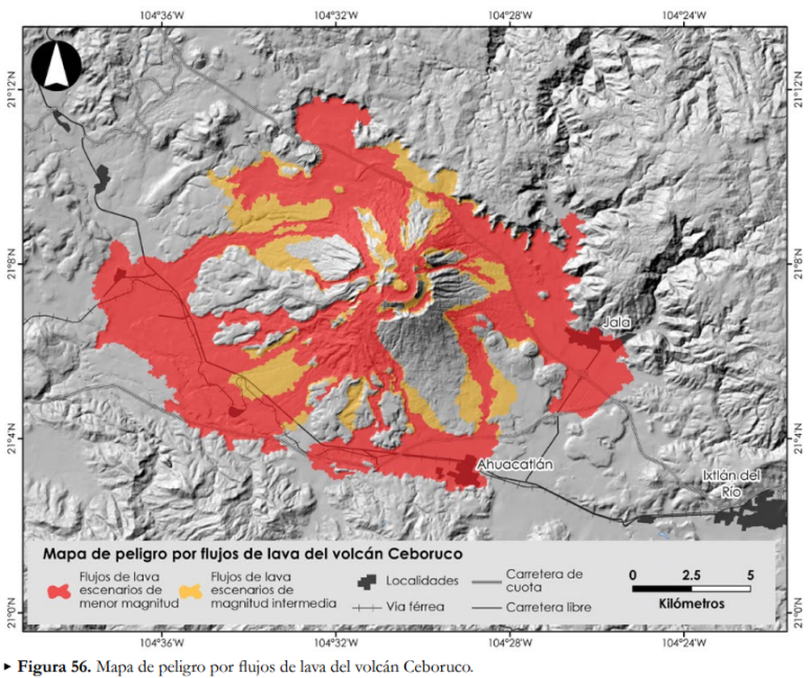
Mapa de peligro por flujos de lava del volcán Ceboruco
(Lava flow hazard map for Ceboruco volcano)
Figure 56 in: Ferrés López, D., Sieron, K., González Zuccolotto, K., Constantinescu, R., Agustín Flores, J., Siebe Grabach, C., Capra Pedol, L., Connor, L., & Connor, C.B. (2019). Memoria técnica del mapa de peligros del volcán Ceboruco (Nayarit). Monografías del Instituto de Geofísica, 24.
Official, Figure in hazard assessment
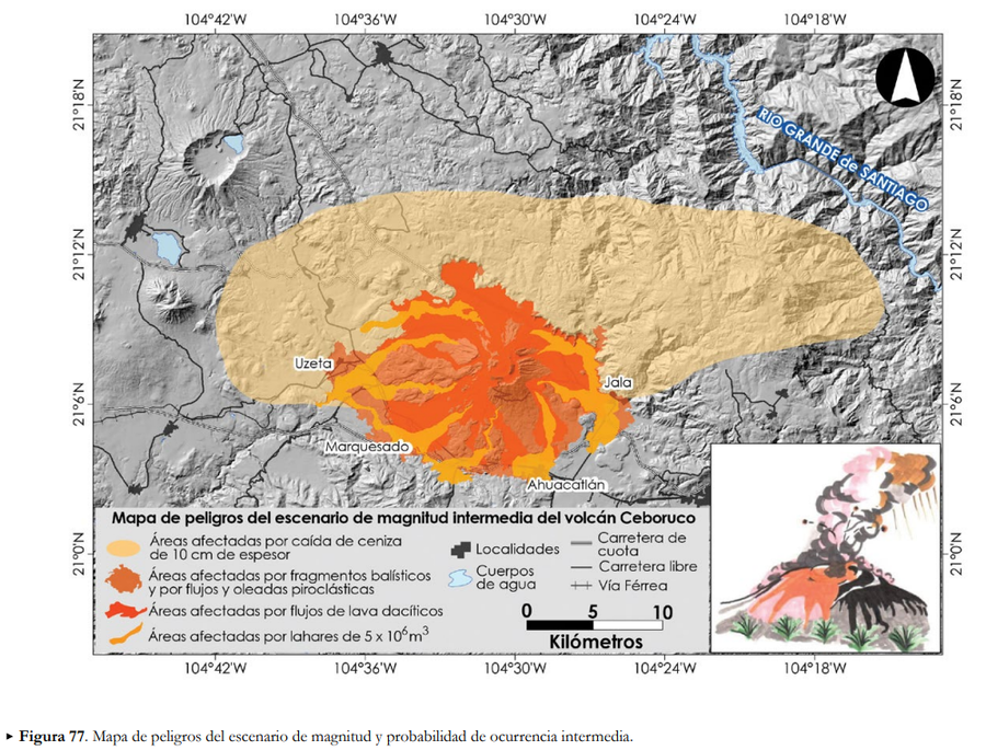
Mapa de peligros del escenario de magnitud intermedia del volcán Ceboruco
(Hazard map of the intermediate magnitude scenario of Ceboruco volcano)
Figure 77 in: Ferrés López, D., Sieron, K., González Zuccolotto, K., Constantinescu, R., Agustín Flores, J., Siebe Grabach, C., Capra Pedol, L., Connor, L., & Connor, C.B. (2019). Memoria técnica del mapa de peligros del volcán Ceboruco (Nayarit). Monografías del Instituto de Geofísica, 24.
Official, Figure in hazard assessment
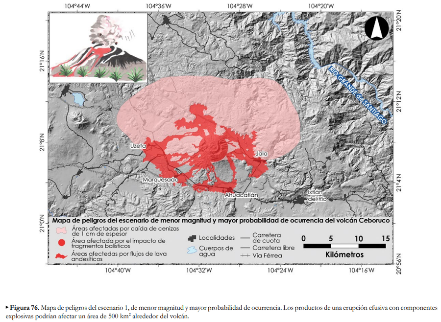
Mapa de peligros del escenario de menor magnitud y mayor probabilidad de ocurrencia del volcán Ceboruco
(Hazard map of the scenario of lower magnitude and greater probability of occurrence for Ceboruco volcano)
Figure 76 in: Ferrés López, D., Sieron, K., González Zuccolotto, K., Constantinescu, R., Agustín Flores, J., Siebe Grabach, C., Capra Pedol, L., Connor, L., & Connor, C.B. (2019). Memoria técnica del mapa de peligros del volcán Ceboruco (Nayarit). Monografías del Instituto de Geofísica, 24.
Official, Map sheet or poster
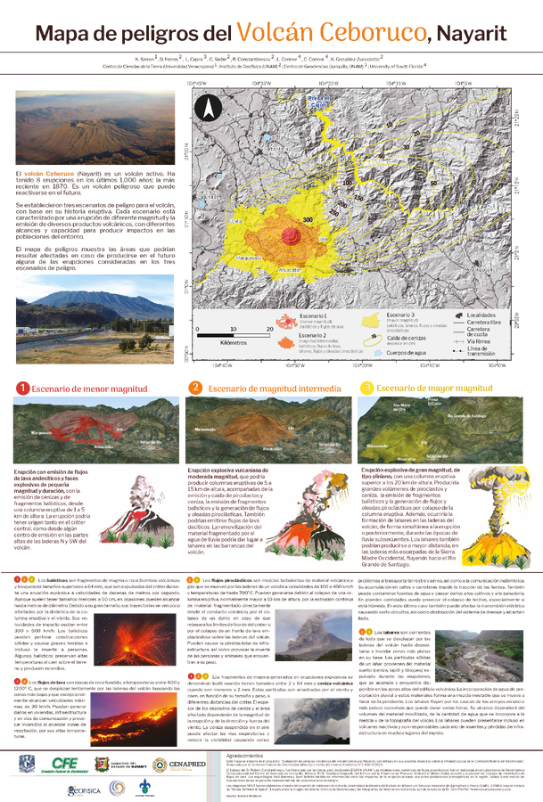
Mapa de peligros del Volcán Ceboruco, Nayarit
(Hazard map of Ceboruco Volcano, Nayarit)
Sieron, K., Ferrés, D., Capra, L., Siebe, C., Constantinescu, R., Connor, L., Connor, C., & González-Zuccolotto, K. (2019). Mapa de peligros del Volcán Ceboruco, Nayarit.
Official, Figure in hazard assessment
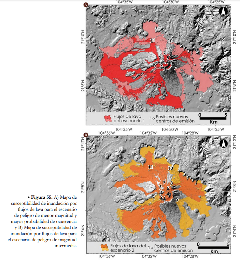
Mapa de susceptibilidad de inundación por flujos de lava
(Lava flow inundation susceptibility map)
Figure 55 in: Ferrés López, D., Sieron, K., González Zuccolotto, K., Constantinescu, R., Agustín Flores, J., Siebe Grabach, C., Capra Pedol, L., Connor, L., & Connor, C.B. (2019). Memoria técnica del mapa de peligros del volcán Ceboruco (Nayarit). Monografías del Instituto de Geofísica, 24.
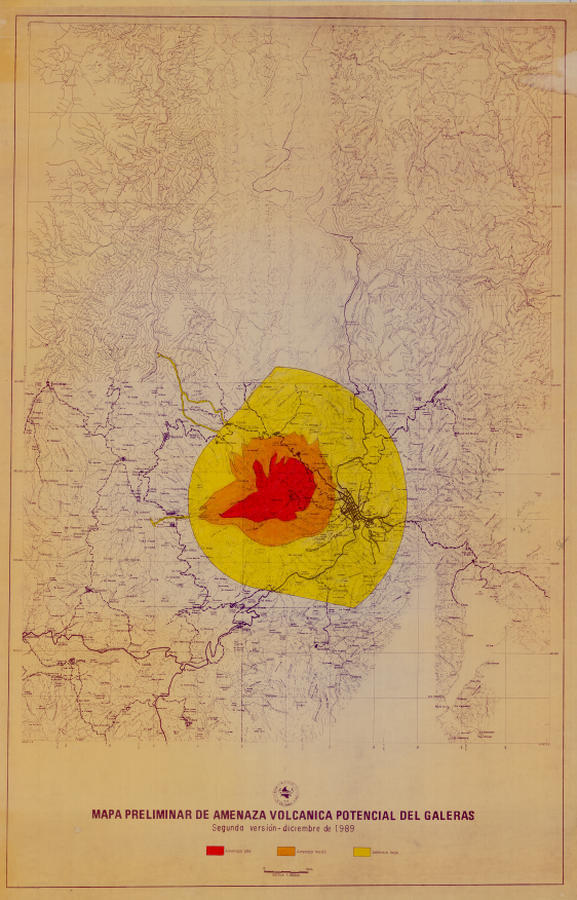
Official, Insert/poster-size map with accompanying report
Mapa Preliminar de Amenaza Volcanica Potencial del Galeras, Segunda versión - Diciembre de 1989
(Preliminary Map of Potential Volcanic Hazards of Galeras, Second version - December 1989)
Pocket insert in: Pulgarin, B., Cepeda, H., Calvache, M. & Alvardo A. (1989). Mapa Preliminar de Amenaza Volcanica Potencial del Galeras. Segunda Versión. Instituto Nacional de Investigaciones Geologico - Mineras (INGEOMINAS). Popayan.

Figure in a journal article
Maps showing the average probability of accumulating ≥10 mm of ash in the event of a–c a basaltic Plinian eruption from Ruawahia Dome, a vent in the Tarawera LVZ, and d–f an initial Plinian phase of a rhyolitic Plinian eruption from Ruawahia Dome, for fruit farms in the BoP
Figure 9 in: Thompson, M. A., Lindsay, J. M., Wilson, T. M., Biass, S., & Sandri, L. (2017). Quantifying risk to agriculture from volcanic ashfall: a case study from the Bay of Plenty, New Zealand. Natural Hazards, 86(1), 31-56. https://doi.org/10.1007/s11069-016-2672-7