
Advanced Search for Maps
Showing 61-68 of 68

Official, Figure on website
Simplified volcano hazards map of Lassen Volcanic Center, California
Clynne, M.A., Robinson, J.E., Nathenson, M., Muffler, L.J.P., Driedger, C.L., Scott, W.E., Iverson, R.M., & Faust, L.M. (2014). Simplified volcano hazards map of Lassen Volcanic Center, California. U.S. Geological Survey. Lassen Volcanic Center, CA Simplified Hazards Map. https://www.usgs.gov/media/images/lassen-volcanic-center-ca-simplified-hazards-map (Modified from: U.S. Geological Survey, Scientific Investigations Report 2012-5176-A)
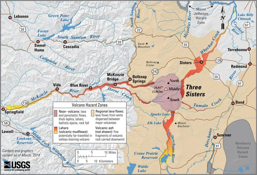
Official, Figure on website
Simplified volcano hazards map of Three Sisters, Oregon
Scott, W.E., Iverson, R.M., Schilling, S.P., Fisher, B.J., Driedger, C.L., Ramsey, D.W., & Faust, L.M. (2014). Simplified volcano hazards map of Three Sisters, Oregon. U.S. Geological Survey. Three Sisters, OR Simplified Hazards Map. https://www.usgs.gov/media/images/three-sisters-or-simplified-hazards-map (Modified from: U.S. Geological Survey, Open-File Report 99-437)
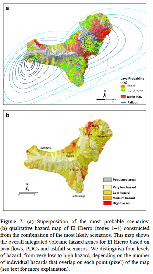
Figure in a journal article
Superposition of the most probable scenarios; qualitative hazard map of El Hierro (zones 1–4) constructed from the combination of the most likely scenarios
Figure 7 in: Becerril, L., Bartolini, S., Sobradelo, R., Martí, J., Morales, J. M., & Galindo, I. (2014). Long-term volcanic hazard assessment on El Hierro (Canary Islands). Natural Hazards and Earth System Sciences, 14(7), 1853-1870. https://doi.org/10.5194/nhess-14-1853-2014, 2014

Figure in a journal article
The hazard map for lava flows at Ceboruco volcano
Figure 5 in: Sieron, K., Ferrés, D., Siebe, C., Constantinescu, R., Capra, L., Connor, C., Connor, L., Groppelli, G. & Zuccolotto, K.G. (2019). Ceboruco hazard map: part II—modeling volcanic phenomena and construction of the general hazard map. Natural Hazards, 96(2), p. 893-933. https://doi.org/10.1007/s11069-019-03577-5
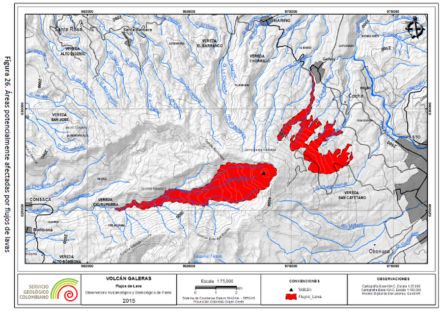
Official, Figure in hazard assessment
Volcán Galeras, Flujos de Lava
(Galeras Volcano, Lava Flows)
Figure 26 in: Servicio Geológico Colombiano (SGC) Direccion de Geoamenazas. (2015). Implementación de Herramientas Computacionales para la Simulación de Fenómenos Volcánicos, Como Soporte en la Actualización del Mapa de Amenaza del Volcánica Del Volcán Galeras – Colombia, Informe Técnico de Simulaciones. En cumplimiento a la Sentencia de la Corte Constitucional T-269 de 2015.
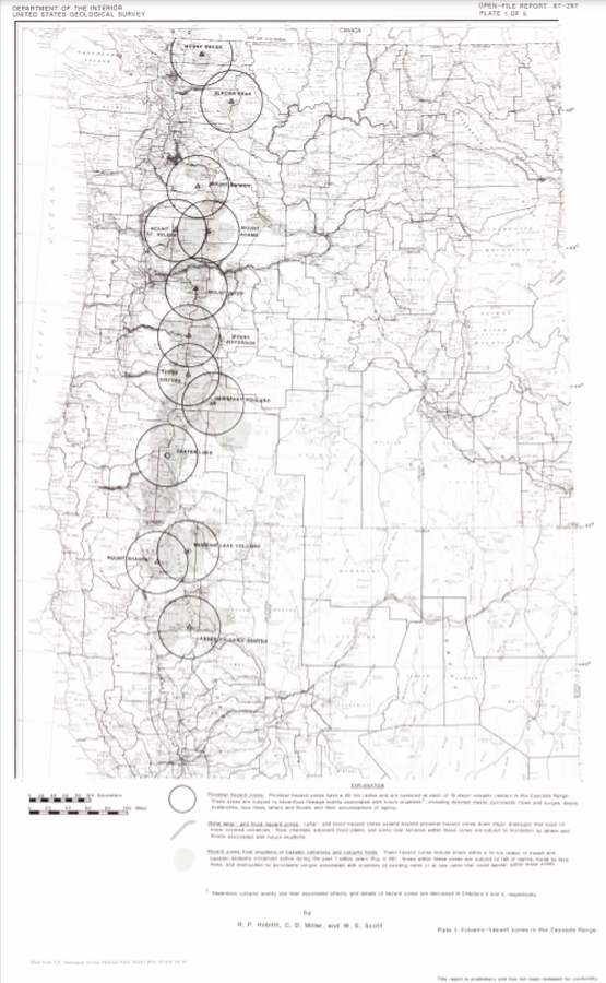
Official, Insert/poster-size map with accompanying report
Volcanic-hazard zones in the Cascades Range
Plate 1 in: Hoblitt, R. P., Miller, C. D., & Scott, W. E. (1987). Volcanic hazards with regard to siting nuclear-power plants in the Pacific Northwest. U.S. Geological Survey, Open-File Report 87-297. https://doi.org/10.3133/ofr87297
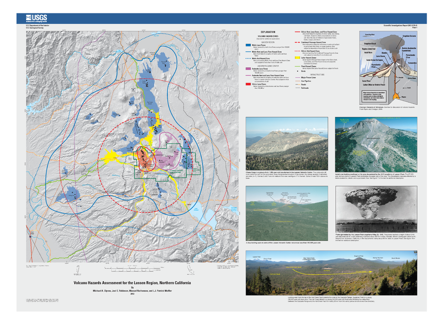
Official, Insert/poster-size map with accompanying report
Volcano Hazards Assessment for the Lassen Region, Northern California
Plate 1 in: Clynne, M. A., Robinson, J. E., Nathenson, M. & Muffler, L. P. (2012). Volcano hazards assessment for the Lassen region, northern California. U.S. Geological Survey, Scientific Investigations Report 2012-5176-A, 47 p., 1 plate. https://doi.org/10.3133/sir20125176A

Official, Insert/poster-size map with accompanying report
Volcano hazards in the Three Sisters Region, Oregon
Plate 1 in: Scott, W.E., Iverson, R., Schilling, S.P. & Fisher, B.J. (2001). Volcano Hazards in the Three Sisters Region, Oregon. U.S. Geological Survey, Open-File Report 99-437, 14 p., 1 plate. https://doi.org/10.3133/ofr99437