
Advanced Search for Maps
Showing 21-30 of 68
Official, Insert/poster-size map with accompanying report
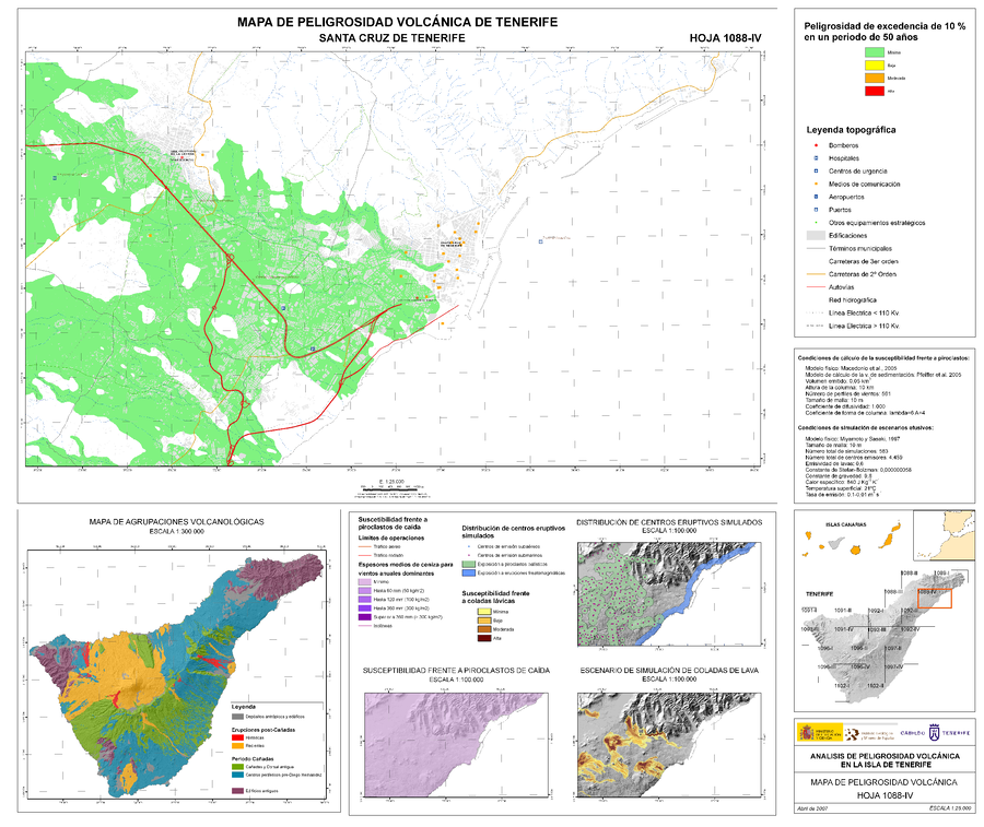
Analisis de Peligrosidad Volcánica en la Isla de Tenerife - Mapa de Peligrosidad Volcánica - Santa Cruz de Tenerife
(Volcanic Hazard Analysis on the Island of Tenerife - Volcanic Hazard Map - Santa Cruz de Tenerife)
Sheet 1088-IV in: Instituto Geológico y Minero de España (IGME). (2006). Plan Territorial Especial de Ordenación para la Prevención de Riesgos. Documento Cartográfico (Planos de Información - Anexo Cartografía Peligrosidad Volcánica).

Official, Insert/poster-size map with accompanying report
Analisis de Peligrosidad Volcánica en la Isla de Tenerife - Mapa de Peligrosidad Volcánica - Santiago del Teide
(Volcanic Hazard Analysis on the Island of Tenerife - Volcanic Hazard Map - Santiago del Teide)
Sheet 1091-III in: Instituto Geológico y Minero de España (IGME). (2006). Plan Territorial Especial de Ordenación para la Prevención de Riesgos. Documento Cartográfico (Planos de Información - Anexo Cartografía Peligrosidad Volcánica).
Official, Insert/poster-size map with accompanying report
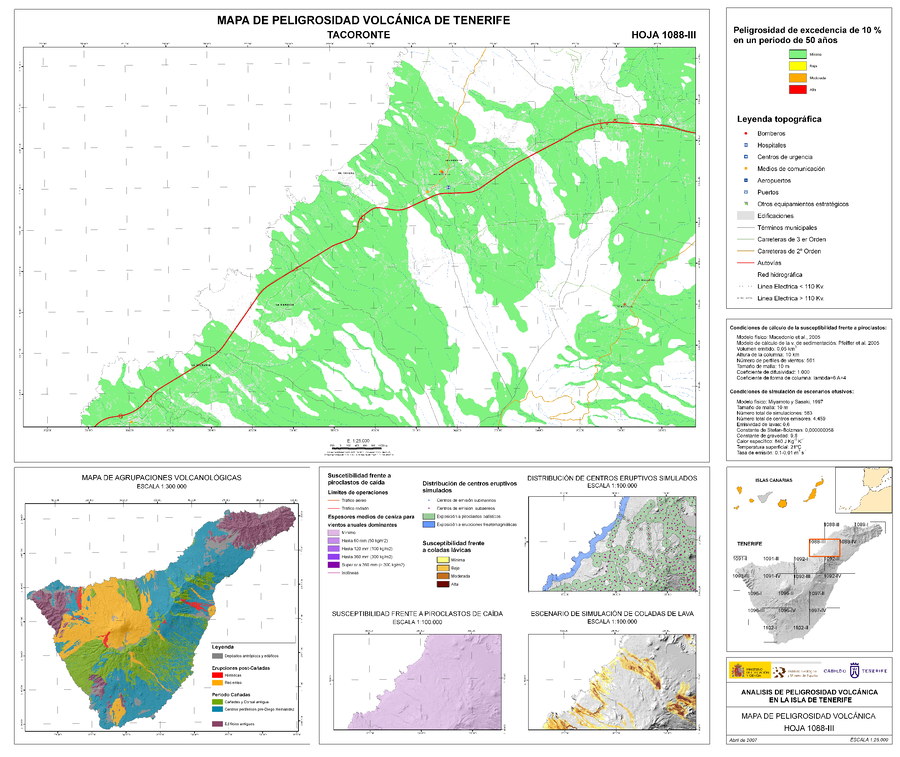
Analisis de Peligrosidad Volcánica en la Isla de Tenerife - Mapa de Peligrosidad Volcánica - Tacoronte
(Volcanic Hazard Analysis on the Island of Tenerife - Volcanic Hazard Map - Tacoronte)
Sheet 1088-III in: Instituto Geológico y Minero de España (IGME). (2006). Plan Territorial Especial de Ordenación para la Prevención de Riesgos. Documento Cartográfico (Planos de Información - Anexo Cartografía Peligrosidad Volcánica).
Official, Insert/poster-size map with accompanying report
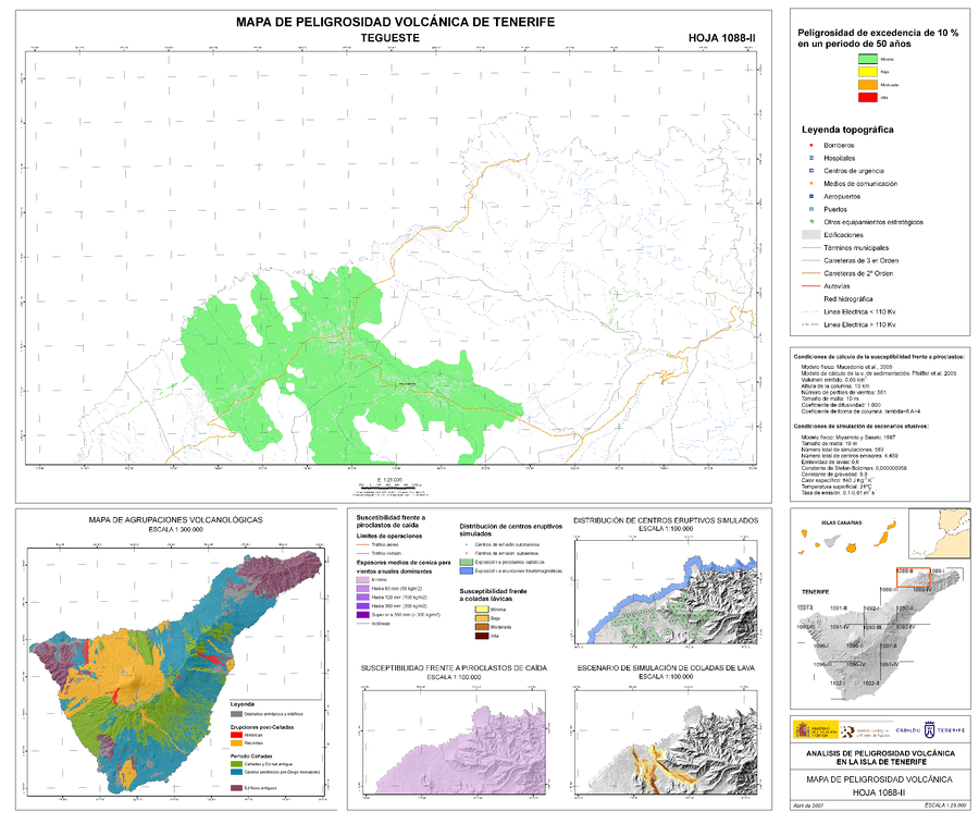
Analisis de Peligrosidad Volcánica en la Isla de Tenerife - Mapa de Peligrosidad Volcánica - Tegueste
(Volcanic Hazard Analysis on the Island of Tenerife - Volcanic Hazard Map - Tegueste)
Sheet 1088-II in: Instituto Geológico y Minero de España (IGME). (2006). Plan Territorial Especial de Ordenación para la Prevención de Riesgos. Documento Cartográfico (Planos de Información - Anexo Cartografía Peligrosidad Volcánica).
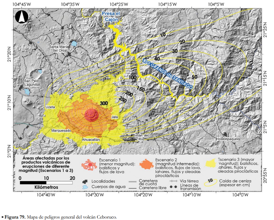
Official, Figure in hazard assessment
Áreas afectadas por los productos volcánicos de erupciones de diferente magntiud (Escenarios 1 a 3)
(Areas affected by the volcanic products of eruptions of different magnitudes (Scenarios 1 to 3))
Figure 79 in: Ferrés López, D., Sieron, K., González Zuccolotto, K., Constantinescu, R., Agustín Flores, J., Siebe Grabach, C., Capra Pedol, L., Connor, L., & Connor, C.B. (2019). Memoria técnica del mapa de peligros del volcán Ceboruco (Nayarit). Monografías del Instituto de Geofísica, 24.
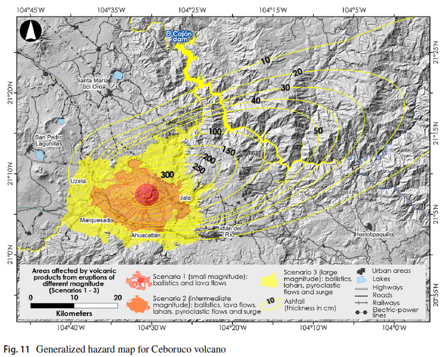
Figure in a journal article
Areas affected by volcanic products from eruptions of different magnitude (Scenarios 1-3)
Figure 11 in: Sieron, K., Ferrés, D., Siebe, C., Constantinescu, R., Capra, L., Connor, C., Connor, L., Groppelli, G. & Zuccolotto, K.G. (2019). Ceboruco hazard map: part II—modeling volcanic phenomena and construction of the general hazard map. Natural Hazards, 96(2), p. 893-933. https://doi.org/10.1007/s11069-019-03577-5
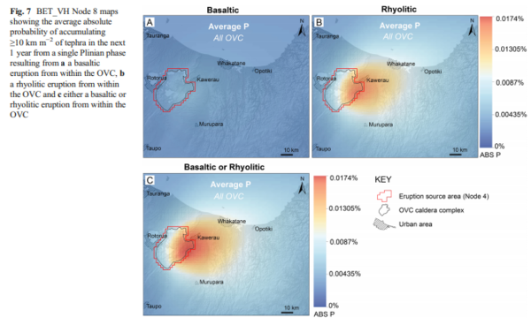
Figure in a journal article
BET_VH Node 8 maps showing the average absolute probability of accumulating ≥10 km m−2 of tephra in the next 1 year from a single Plinian phase resulting from a a basaltic eruption from within the OVC, b a rhyolitic eruption from within the OVC and c either a basaltic or rhyolitic eruption from within the OVC
Figure 7 in: Thompson, M. A., Lindsay, J. M., Sandri, L., Biass, S., Bonadonna, C., Jolly, G., & Marzocchi, W. (2015). Exploring the influence of vent location and eruption style on tephra fall hazard from the Okataina Volcanic Centre, New Zealand. Bulletin of volcanology, 77(5), 38. https://doi.org/10.1007/s00445-015-0926-y
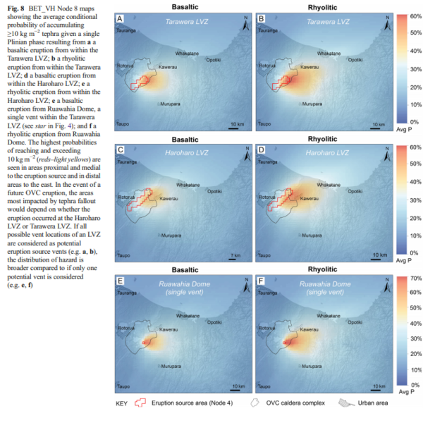
Figure in a journal article
BET_VH Node 8 maps showing the average conditional probability of accumulating ≥10 kg m−2 tephra given a single Plinian phase resulting from a a basaltic eruption from within the Tarawera LVZ; b a rhyolitic eruption from within the Tarawera LVZ; d a basaltic eruption from within the Haroharo LVZ; e a rhyolitic eruption from within the Haroharo LVZ; e a basaltic eruption from Ruawahia Dome, a single vent within the Tarawera LVZ (see star in Fig. 4); and f a rhyolitic eruption from Ruawahia Dome
Figure 8 in: Thompson, M. A., Lindsay, J. M., Sandri, L., Biass, S., Bonadonna, C., Jolly, G., & Marzocchi, W. (2015). Exploring the influence of vent location and eruption style on tephra fall hazard from the Okataina Volcanic Centre, New Zealand. Bulletin of volcanology, 77(5), 38. https://doi.org/10.1007/s00445-015-0926-y
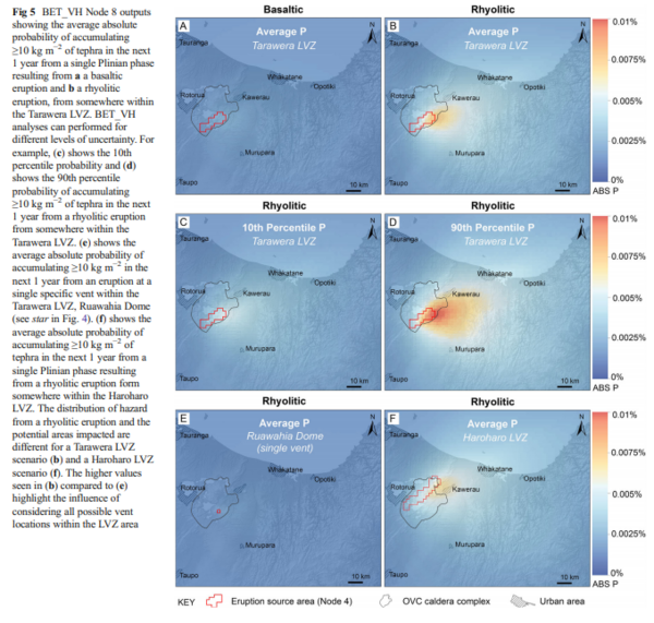
Figure in a journal article
BET_VH Node 8 outputs showing the average absolute probability of accumulating ≥10 kg m−2 of tephra in the next 1 year from a single Plinian phase resulting from a a basaltic eruption and b a rhyolitic eruption, from somewhere within the Tarawera LVZ
Figure 5 in: Thompson, M. A., Lindsay, J. M., Sandri, L., Biass, S., Bonadonna, C., Jolly, G., & Marzocchi, W. (2015). Exploring the influence of vent location and eruption style on tephra fall hazard from the Okataina Volcanic Centre, New Zealand. Bulletin of volcanology, 77(5), 38. https://doi.org/10.1007/s00445-015-0926-y
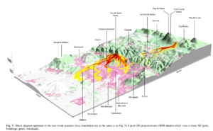
Figure in a journal article
Block diagram appraisal of the two event scenario
Figure 9 in: Latutrie, B., Andredakis, I., De Groeve, T., Harris, A. J. L., Langlois, E., de Vries, B. V. W., Saubin, E., Bilotta, G., Cappello, A., Crisci, G.M., D'ambrosio, D., Del Negro, C., Favalli, M., Fujita, E., Iovine, G., Kelfoun, K., Rongo, R., Spataro, W., Tarquini, S., Coppola, D., Ganci, G., Marchese, F., Pergola, N., & Tramutoli, V. (2016). Testing a geographical information system for damage and evacuation assessment during an effusive volcanic crisis. In: Harris, A.J.L., De Groeve, T., & Carn, S.A. (Eds.) Detecting, Modelling and Responding to Effusive Eruptions. Geological Society, London, Special Publications, 426(1), p. 649-672. https://doi.org/10.1144/SP426.19