
Advanced Search for Maps
Showing 51-60 of 68
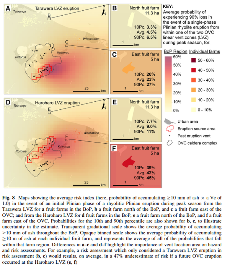
Figure in a journal article
Maps showing the average risk index (here, probability of accumulating ≥10 mm of ash × a Vc of 1.0) in the event of an initial Plinian phase of a rhyolitic Plinian eruption during peak season from the Tarawera LVZ for a fruit farms in the BoP
Figure 8 in: Thompson, M. A., Lindsay, J. M., Wilson, T. M., Biass, S., & Sandri, L. (2017). Quantifying risk to agriculture from volcanic ashfall: a case study from the Bay of Plenty, New Zealand. Natural Hazards, 86(1), 31-56. https://doi.org/10.1007/s11069-016-2672-7
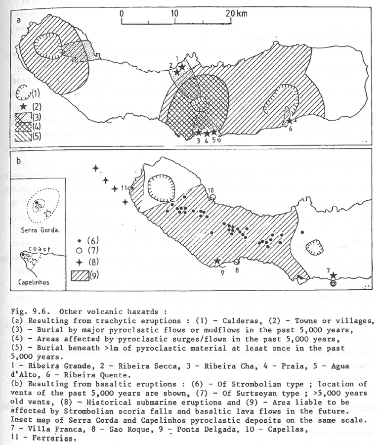
Figure in a journal article
Other volcanic hazards
Figure 9.6 in: Booth, B., Croasdale, R., & Walker, G.L. (1983). Volcanic hazard on Sao Miguel, Azores. In: Tazieff, H. & Sabroux, J.C. (eds.). Forecasting Volcanic Events. Elsevier, Amsterdam. p. 99-109.
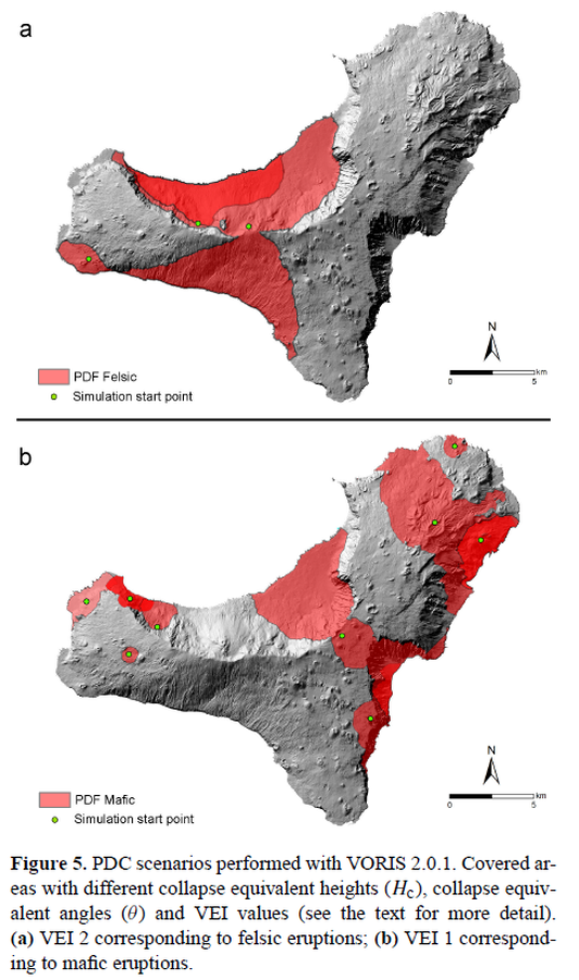
Figure in a journal article
PDC scenarios performed with VORIS 2.0.1
Figure 5 in: Becerril, L., Bartolini, S., Sobradelo, R., Martí, J., Morales, J. M., & Galindo, I. (2014). Long-term volcanic hazard assessment on El Hierro (Canary Islands). Natural Hazards and Earth System Sciences, 14(7), 1853-1870. https://doi.org/10.5194/nhess-14-1853-2014, 2014
Official, Map sheet or poster
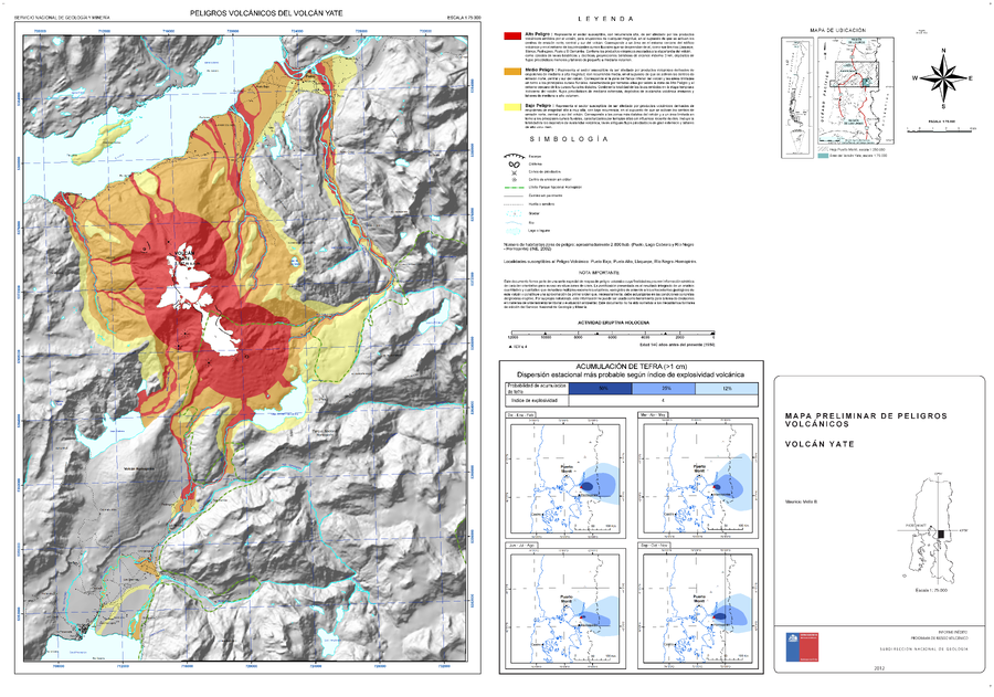
Peligros Volcánicos del Volcán Yate
(Volcanic Hazards of Yate Volcano)
Mella, M. (2012). Mapa Preliminar de peligros volcánicos Volcán Yate, región de Los Lagos. Informe inédito, Subdirección Nacional de Geología, Programa de Riesgo Volcánico, mapa escala 1:75.000. Santiago.
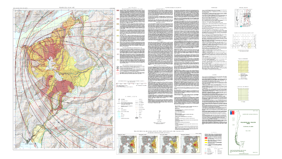
Official, Map sheet or poster
Peligros Volcánicos del Volcán Yate
(Volcanic Hazards of Yate Volcano)
Mella, M. (2017). Peligros del Volcán Yate, región de Los Lagos. Servicio Nacional de Geología y Minería, Carta Geológica de Chile, Serie Geología Ambiental 31, mapa escala 1:50.000. Santiago.
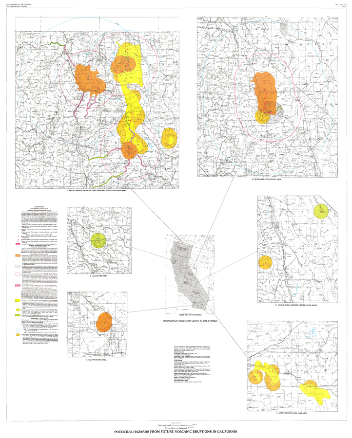
Official, Insert/poster-size map with accompanying report
Potential Hazards from future volcanic eruptions in California
Plate 1 in: Miller, C.D. (1989). Potential hazards from future volcanic eruptions in California. U.S. Geological Survey, Bulletin 1847, 17 p., 2 tables, 1 plate, scale 1:500,000.
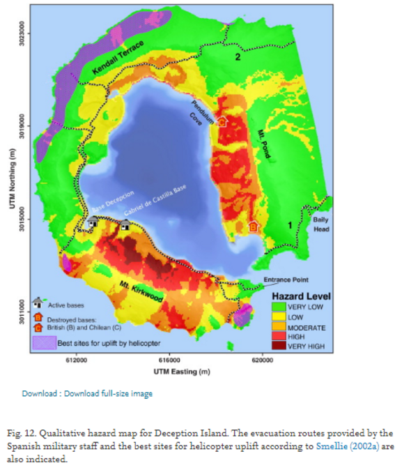
Figure in a journal article
Qualitative hazard map for Deception Island.
Figure 12 in: Bartolini, S., Geyer, A., Martí, J., Pedrazzi, D., & Aguirre-Díaz, G. (2014). Volcanic hazard on Deception Island (South Shetland Islands, Antarctica). Journal of Volcanology and Geothermal Research, 285, p. 150-168. https://doi.org/10.1016/j.jvolgeores.2014.08.009
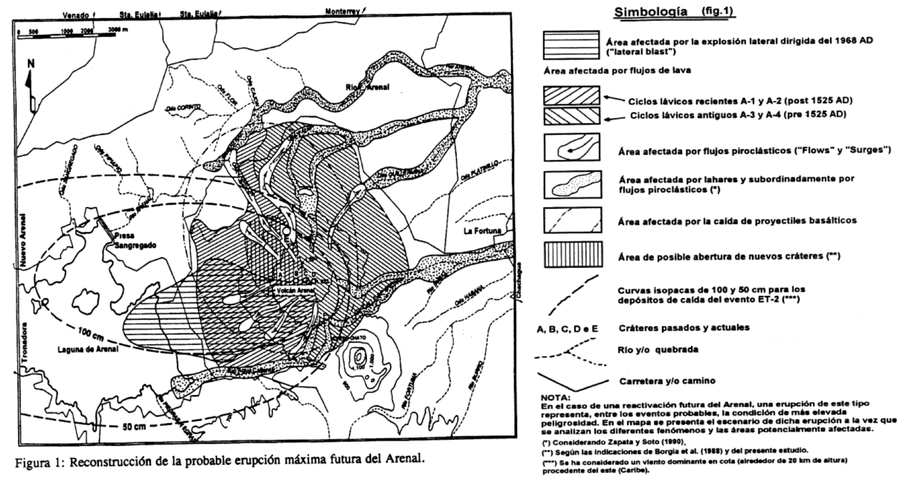
Official, Figure in hazard assessment
Reconstrucción de la probable erupción máxima futura del Arenal
(Reconstruction of the probable future maximum eruption of Arenal)
Figure 1 in: Alvarado, G.E., Soto, G.J., Ghigliotti, M., & Frullani, A. (1997). Peligro volcánico del Arenal. Boletín OSIVAM, 8(15-16), p. 62-82.
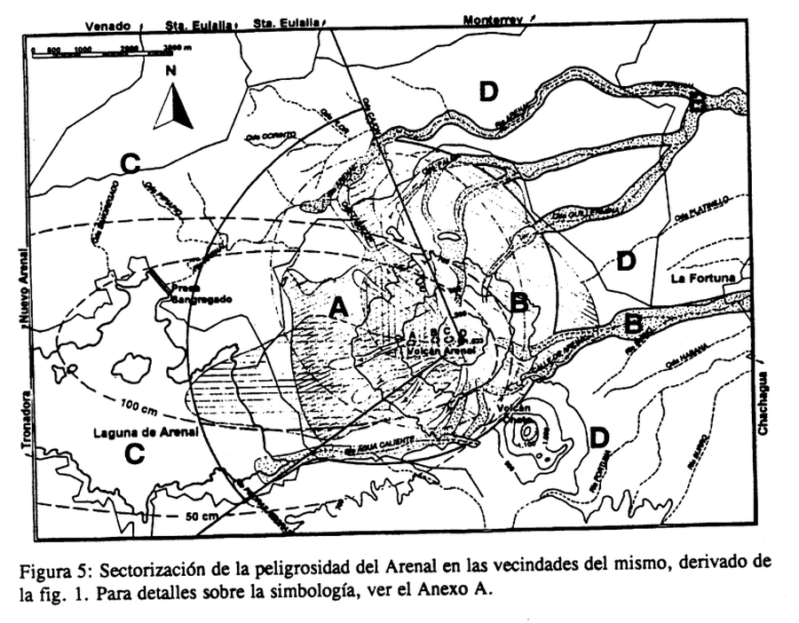
Official, Figure in hazard assessment
Sectorización de la peligrosidad del Arenal en las vecindades del mismo, derivado de la fig. 1
(Sectorization of the danger of Arenal in its vicinity, derived from fig. 1)
Figure 5 in: Alvarado, G.E., Soto, G.J., Ghigliotti, M., & Frullani, A. (1997). Peligro volcánico del Arenal. Boletín OSIVAM, 8(15-16), p. 62-82.
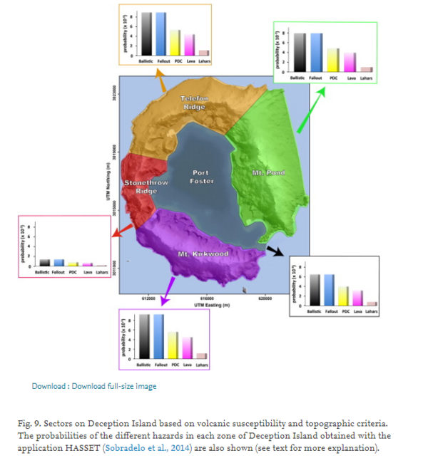
Figure in a journal article
Sectors on Deception Island based on volcanic susceptibility and topographic criteria.
Figure 9 in: Bartolini, S., Geyer, A., Martí, J., Pedrazzi, D., & Aguirre-Díaz, G. (2014). Volcanic hazard on Deception Island (South Shetland Islands, Antarctica). Journal of Volcanology and Geothermal Research, 285, p. 150-168. https://doi.org/10.1016/j.jvolgeores.2014.08.009