← Back to Search Results

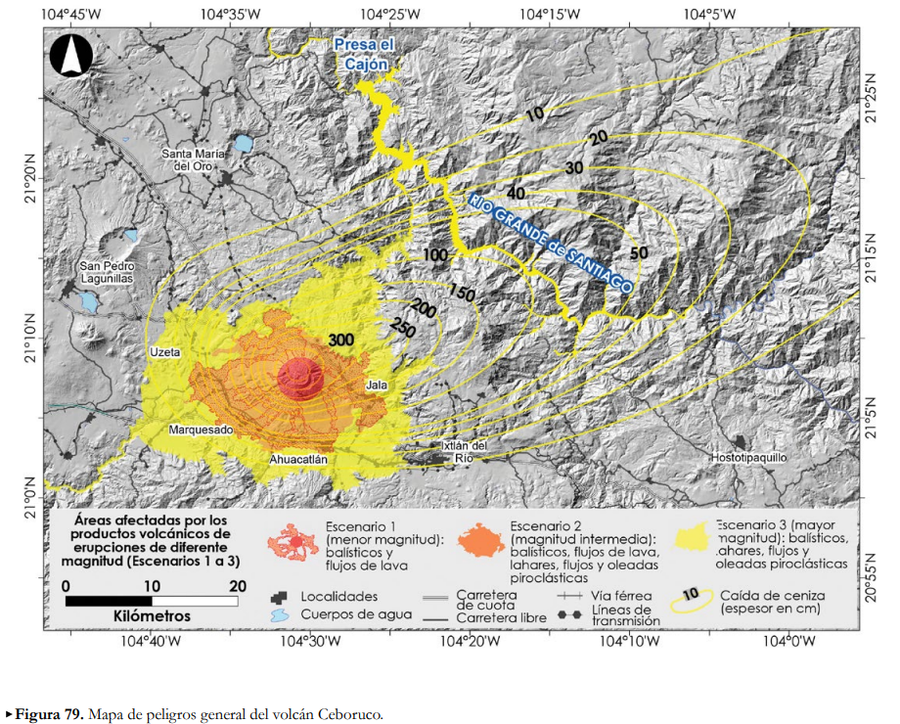
Áreas afectadas por los productos volcánicos de erupciones de diferente magntiud (Escenarios 1 a 3)

Areas affected by the volcanic products of eruptions of different magnitudes (Scenarios 1 to 3)

Ceboruco, Mexico, 2019

Figure 79 in: Ferrés López, D., Sieron, K., González Zuccolotto, K., Constantinescu, R., Agustín Flores, J., Siebe Grabach, C., Capra Pedol, L., Connor, L., & Connor, C.B. (2019). Memoria técnica del mapa de peligros del volcán Ceboruco (Nayarit). Monografías del Instituto de Geofísica, 24.


This map was produced by an official agency, but may not be the most recent, most complete, or main operational map. For the current operational hazard map, please consult the proper institutional authorities.


Click on image for full-size map. If link seems broken, try the archived version.

Map Set

Ferrés Lopez, D., Sieron, K., González Zuccolotto, K., Constantinescu, R., Agustín Flores, J., Siebe, C., Capra, L., Connor, L., & Connor, C.B. (2019). Memoria técnica del mapa de peligros del volcán Ceboruco (Nayarit). Monografías del Instituto de Geofísica, 24.
https://www.geofisica.unam.mx/recursos/docs/editorial/IGEF_monografias_24.pdf

Other Maps In Set:

Map Data

Map ID3802
Hazard Process(es)Ballistics; Lahars; Lava flows; PDCs; Surges
Hazard Zone PresentationHazard level- and process-focused: Hazards are both combined by hazard level and separated by hazard process type on a main map panel
Temporal ScaleBackground, or long-term, map
Spatial ScaleVolcano and surrounding area
Publication FormatFigure in a hazard assessment or mitigation plan
Zonation Method(s)Probabilistic modeling; Scenario modeling
Zonation Model(s)Eject! (Mastin 2001); Energy cone or line (Heim 1932; Sheridan 1979; Sheridan & Malin 1983); Etna Lava Flow Model (Damiani et al. 2006); FLO-2D (O'Brien 1993); LAHARZ or modified version (such as PFZ) (Iverson et al. 1998; Schilling 1998; Schilling 2014); TITAN2D (Pitman et al. 2003; Patra et al. 2005)
Scenario(s) ConsideredComposition; Size, VEI, or intensity; Source location or direction; Style or type
Hazard Zone Label(s)Scenario name
Probability Definition(s)Qualitative relative probability (e.g. high-medium-low)
PurposeMultiple: intended for multiple purposes including general hazard awareness, planning, and crisis management
AudienceMultiple audiences (usually the public, civil authorities, and land-use planners)
Language(s)Spanish
Basemap(s)Hillshade
Basemap overlay(s)Street map
DiemsionalityPlanimetric (2D or map) view
Color SchemeRed to Yellow
Go to Global Volcanism Program page for Ceboruco →