
Advanced Search for Maps
Showing 1-10 of 15
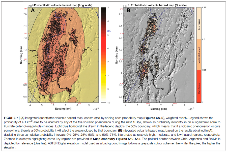
Figure in a journal article
Integrated quantitative volcanic hazard map, constructed by adding each probability map (Figures 6A–E), weighted evenly
Figure 7 in: Bertin, D., Lindsay, J.M., Cronin, S.J., de Silva, S.L., Connor, C.B., Caffe, P.J., Grosse, P., Báez, W., Bustos, E., & Constantinescu, R. (2022). Probabilistic Volcanic Hazard Assessment of the 22.5–28° S Segment of the Central Volcanic Zone of the Andes. Frontiers in Earth Science, 10. https://doi.org/10.3389/feart.2022.875439
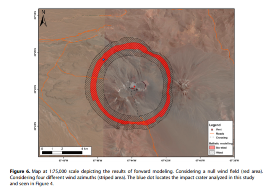
Figure in a journal article
Map at 1:75,000 scale depicting the results of forward modeling
Figure 6 in: Bertin, D. (2017). 3‐D ballistic transport of ellipsoidal volcanic projectiles considering horizontal wind field and variable shape‐dependent drag coefficients. Journal of Geophysical Research: Solid Earth, 122(2), p. 1126-1151. https://doi.org/10.1002/2016JB013320
Official, Map sheet or poster
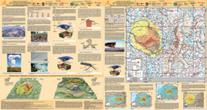
Mapa de Peligros Volcánicos Potenciales del Volcán Guagua Pichincha - 3ra. Edición
(Map of Potential Volcanic Hazards of the Guagua Pichincha Volcano - 3rd. Edition)
IG-EPN, IGM, IRD. (2019). Mapa de Peligros Volcánicos Potenciales del Volcán Guagua Pichincha 3ra. Edición, Quito - Ecuador.
Official, Insert/poster-size map with accompanying report
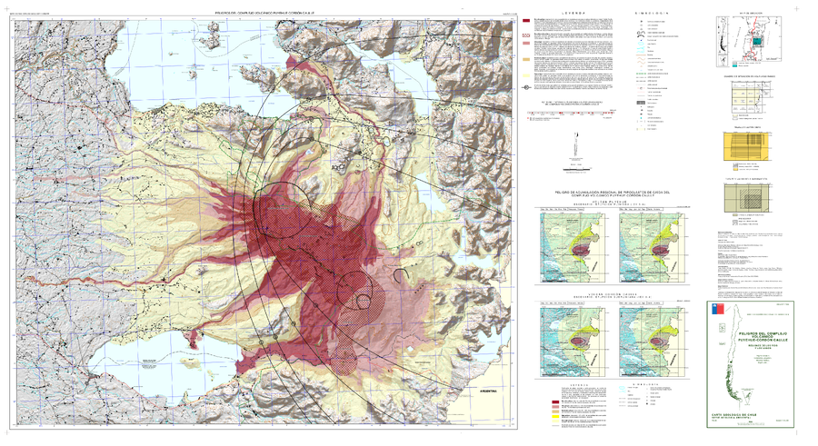
Peligros del Complejo Volcánico Puyehue-Cordón Caulle, regiones de Los Ríos y Los Lagos
(Hazards of the Puyehue-Cordón Caulle Volcanic Complex, Los Ríos and Los Lagos Regions)
Toloza, V., Jorquera, C., Mella, M., Gho, R. (2020). Peligros del Complejo Volcánico Puyehue-Cordón Caulle, regiones de Los Ríos y Los Lagos. Servicio Nacional de Geología y Minería, Carta Geológica de Chile, Serie Geología Ambiental 36, 63 p., 1 mapa escala 1:75.000. Santiago.
Official, Insert/poster-size map with accompanying report
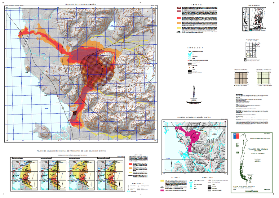
Peligros del Volcán Chaitén
(Hazards of Chaitén Volcano)
Amigo, A., Lara, L.E., & Bertin, D. (2015). Peligros del volcán Chaitén, Región de Los Lagos. Servicio Nacional de Geología y Minería (SERNAGEOMIN), Carta Geológica de Chile, Serie Geología Ambiental 24, 1 mapa escala 1:50.000. Santiago.
Official, Insert/poster-size map with accompanying report
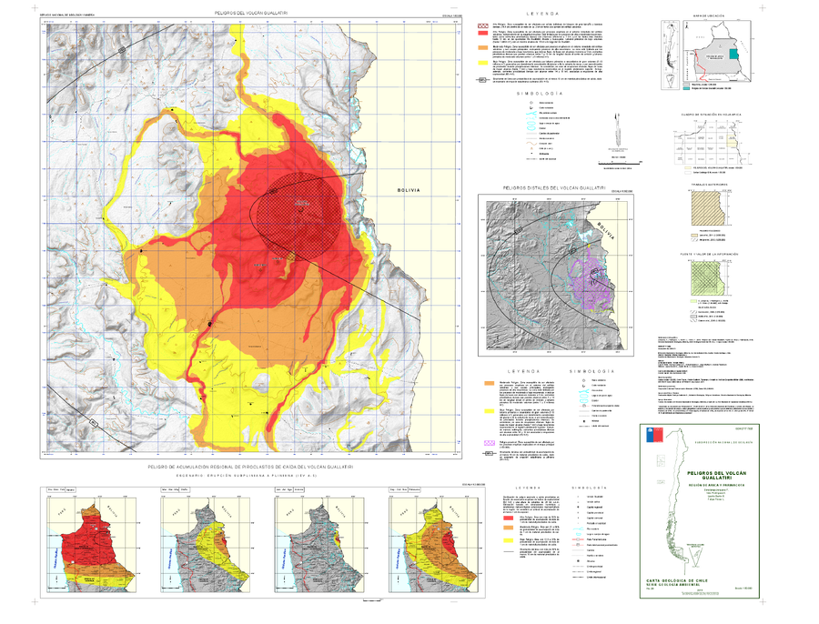
Peligros del Volcán Guallatiri, región de Arica y Parinacota
(Hazards of the Guallatiri Volcano, Arica and Parinacota Region)
Jorquera, C., Rodríguez, I., Bertin, L., & Flores, F. (2019). Peligros del Volcán Guallatiri, región de Arica y Parinacota. Servicio Nacional de Geología y Minería (SERNAGEOMIN), Carta Geológica de Chile, Serie Geología Ambiental 35, 45 p., 1 mapa escala 1:50.000. Santiago.
Official, Insert/poster-size map with accompanying report
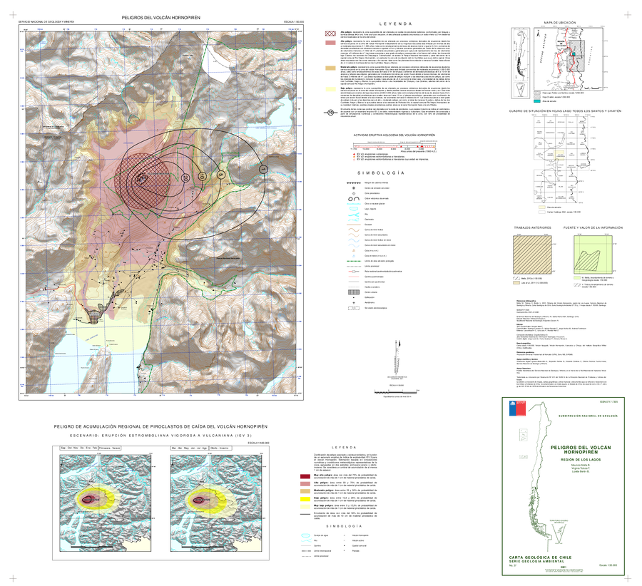
Peligros del Volcán Hornopirén, Región de Los Lagos
(Hazards of the Hornopirén Volcano, Los Lagos Region)
Mella, M., Toloza, V., and Bertin, L. (2021). Peligros del volcán Hornopirén, región de Los Lagos. Servicio Nacional de Geología y Minería, Carta Geológica de Chile, Serie Geología Ambiental 37: 51 p., 1 mapa escala 1:50.000. Santiago.
Official, Insert/poster-size map with accompanying report
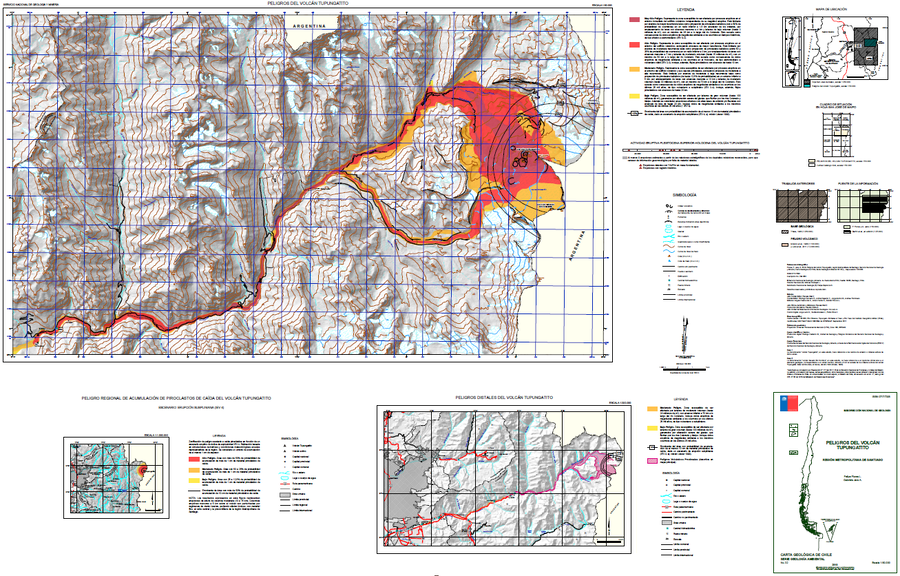
Peligros del Volcán Tupungatito
(Hazards of Tupungatito Volcano)
Flores, F. & Jara, G. (2018). Peligros volcán Tupungatito, Región Metropolitana de Santiago. Servicio Nacional de Geología y Minería (SERNAGEOMIN), Carta Geológica de Chile, Serie Geología Ambiental 32: 35 p., mapa escala 1:50.000. Santiago.
Official, Insert/poster-size map with accompanying report
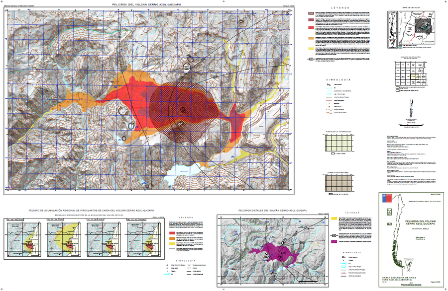
Peligros Volcanicos del Volcán Cerro Azul-Quizapu
(Volcanic Hazards of Cerro Azul-Quizapu Volcano)
Amigo, A. & Bertin, D. (2015). Peligros del volcán Cerro Azul – Quizapu, Región del Maule. Servicio Nacional de Geología y Minería (SERNAGEOMIN), Carta Geológica de Chile, Serie Geología Ambiental, No. 17, p., 1, mapa escala 1:50.000. Santiago.
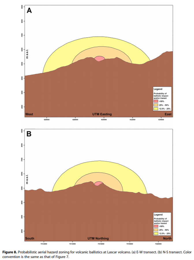
Figure in a journal article
Probabilistic aerial hazard zoning for volcanic ballistics at Lascar volcano
Figure 8 in: Bertin, D. (2017). 3‐D ballistic transport of ellipsoidal volcanic projectiles considering horizontal wind field and variable shape‐dependent drag coefficients. Journal of Geophysical Research: Solid Earth, 122(2), p. 1126-1151. https://doi.org/10.1002/2016JB013320
Page: 1 2