
Advanced Search for Maps
Showing 51-60 of 88
Official, Figure on website
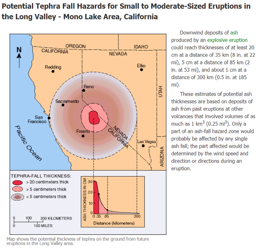
Potential Tephra Fall Hazards for Small to Moderate-Sized Eruptions in the Long Valley - Mono Lake Area, California
U.S. Geological Survey (USGS). (2012). Potential Tephra Fall Hazards for Small to Moderate-Sized Eruptions in the Long Valley - Mono Lake Area, California. U.S. Geological Survey. Long Valley Caldera, Volcano Hazards in the Long Valley - Mono Lake Area, California. https://www.usgs.gov/volcanoes/long-valley-caldera/volcano-hazards-long-valley-mono-lake-area-california
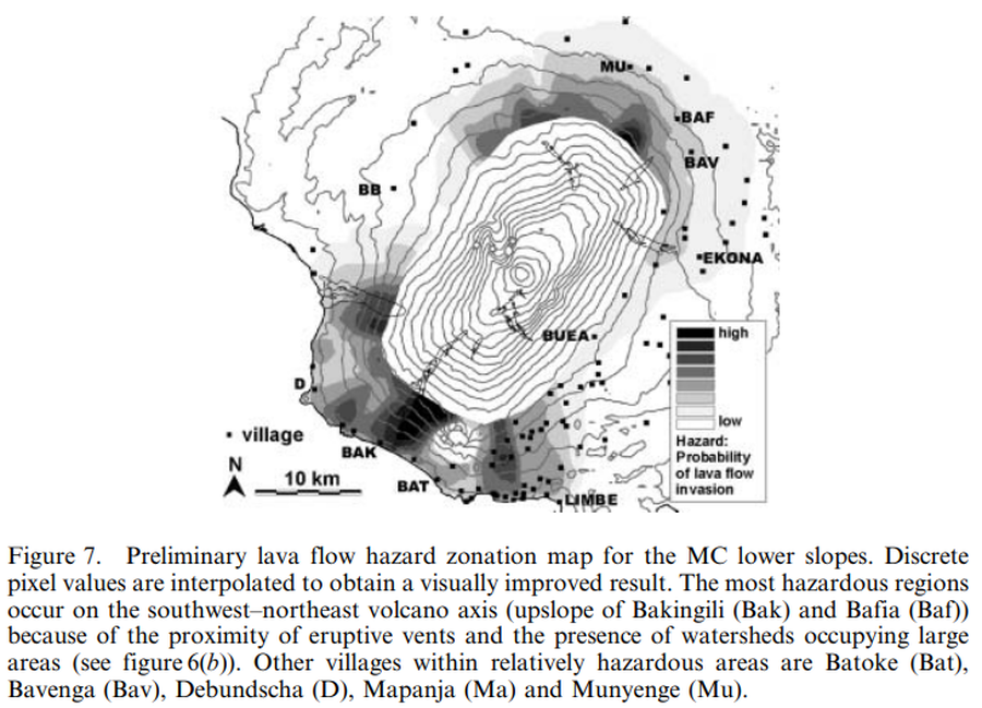
Figure in a journal article
Preliminary lava flow hazard zonation map for the MC lower slopes
Figure 7 in: Bonne, K., Kervyn, M., Cascone, L., Njome, S., Van Ranst, E., Suh, E., Ayonghe, S., & Ernst, G. (2008). A new approach to assess long‐term lava flow hazard and risk using GIS and low‐cost remote sensing: the case of Mount Cameroon, West Africa. International Journal of Remote Sensing, 29(22), 6539-6564. https://doi.org/10.1080/01431160802167873
Official, Map sheet or poster
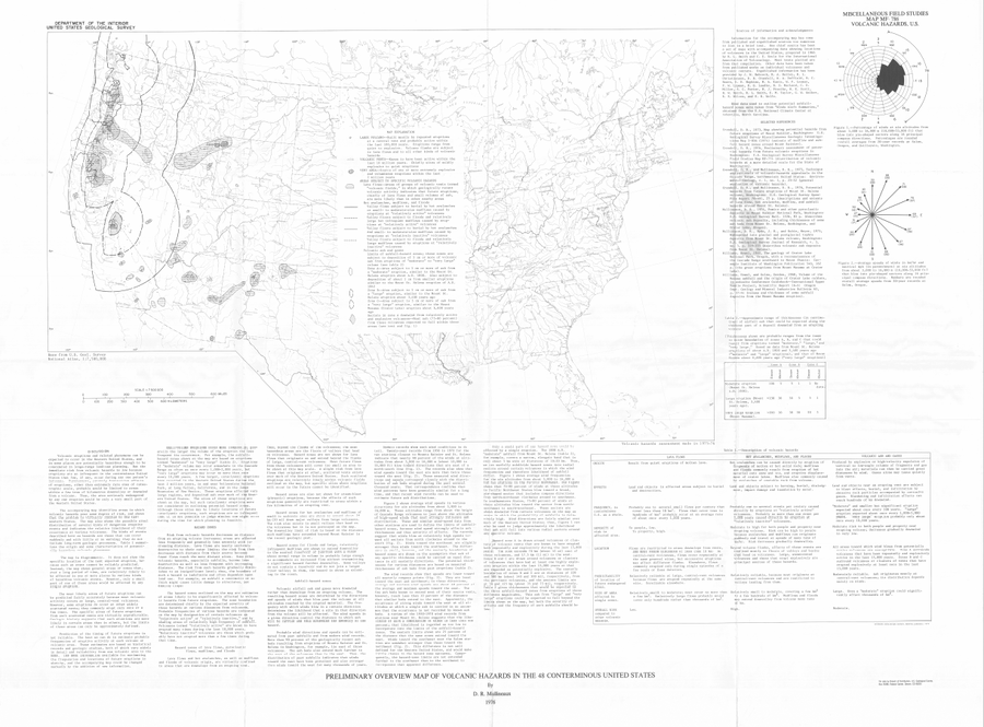
Preliminary Overview Map of Volcanic Hazards in the 48 Coterminous United States
Mullineaux, D.R. (1978). Preliminary overview map of volcanic hazards in the 48 conterminous United States. U.S. Geological Survey, Miscellaneous Field Studies Map 786. https://doi.org/10.3133/mf786
Official, Figure in hazard assessment
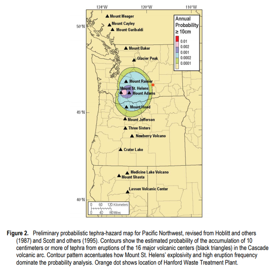
Preliminary probabilistic tephra-hazard map for Pacific Northwest
Figure 2 in: Hoblitt, R.P., & Scott, W.E. (2011). Estimate of tephra accumulation probabilities for the U.S. Department of Energy's Hanford Site, Washington. U.S. Geological Survey, Open-File Report 2011-1064, 15 p. https://doi.org/10.3133/ofr20111064
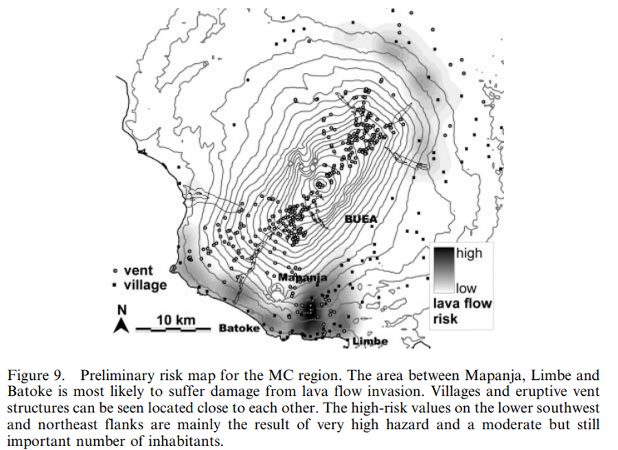
Figure in a journal article
Preliminary risk map for the MC region
Figure 9 in: Bonne, K., Kervyn, M., Cascone, L., Njome, S., Van Ranst, E., Suh, E., Ayonghe, S., & Ernst, G. (2008). A new approach to assess long‐term lava flow hazard and risk using GIS and low‐cost remote sensing: the case of Mount Cameroon, West Africa. International Journal of Remote Sensing, 29(22), 6539-6564. https://doi.org/10.1080/01431160802167873
Official, Insert/poster-size map with accompanying report
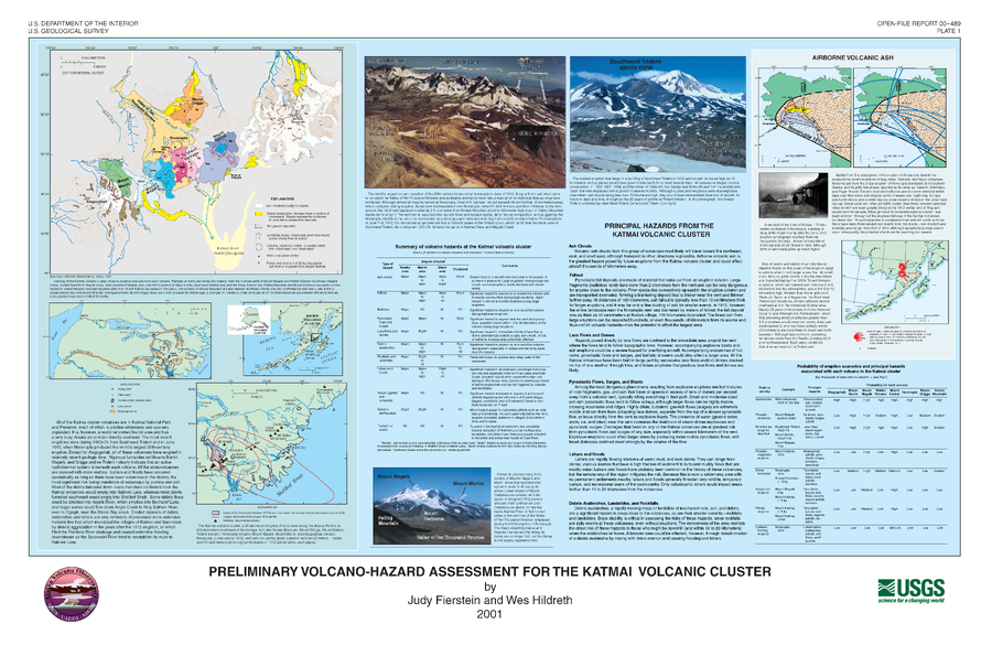
Preliminary Volcano-Hazard Assessment for the Katmai Volcanic Cluster
Plate 1 in: Fierstein, J. & Hildreth, W. (2001). Preliminary volcano-hazard assessment for the Katmai Volcanic Cluster, Alaska. U.S. Geological Survey Open-File Report 00-489, 50 p., 1 plate. https://doi.org/10.3133/ofr00489
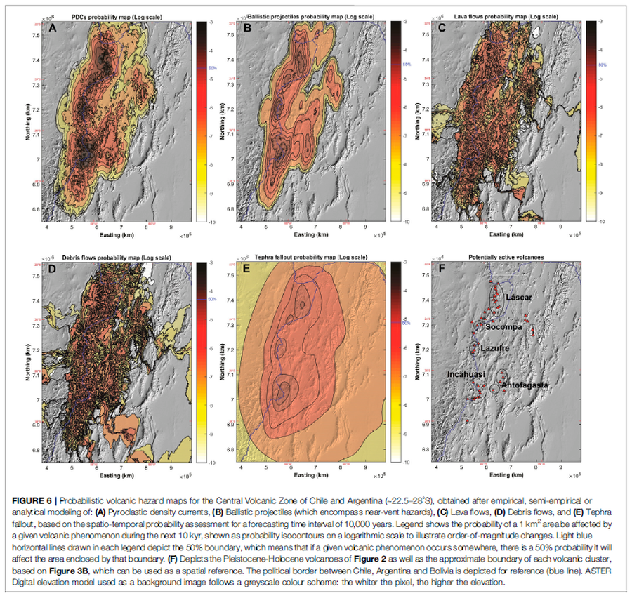
Figure in a journal article
Probabilistic volcanic hazard maps for the Central Volcanic Zone of Chile and Argentina (∼22.5–28°S), obtained after empirical, semi-empirical or analytical modeling
Figure 6 in: Bertin, D., Lindsay, J.M., Cronin, S.J., de Silva, S.L., Connor, C.B., Caffe, P.J., Grosse, P., Báez, W., Bustos, E., & Constantinescu, R. (2022). Probabilistic Volcanic Hazard Assessment of the 22.5–28° S Segment of the Central Volcanic Zone of the Andes. Frontiers in Earth Science, 10. https://doi.org/10.3389/feart.2022.875439
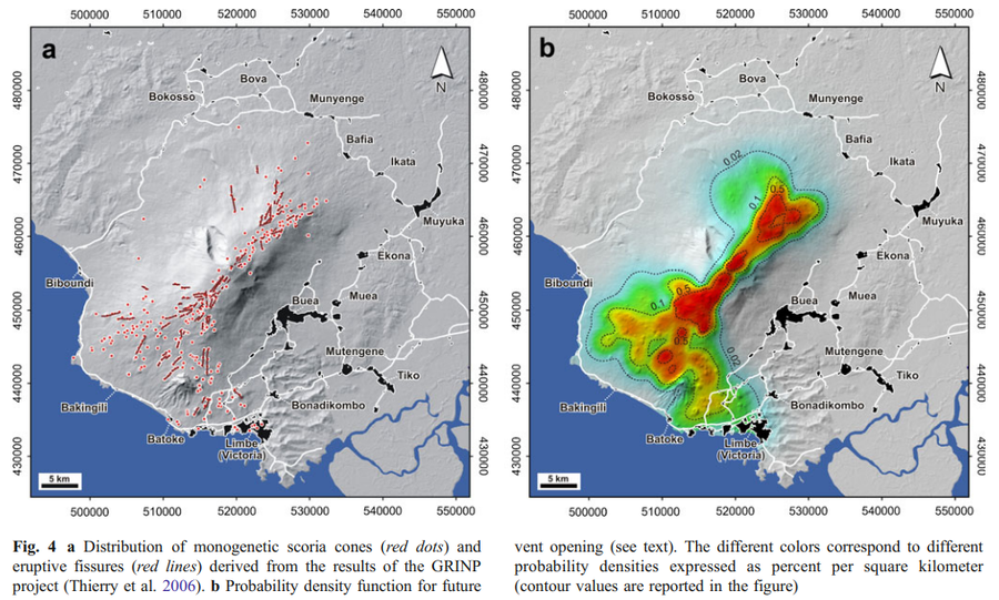
Figure in a journal article
Probability density function for future vent opening.
Figure 4 in: Favalli, M., Tarquini, S., Papale, P., Fornaciai, A., & Boschi, E. (2012). Lava flow hazard and risk at Mt. Cameroon volcano. Bulletin of Volcanology, 74(2), 423-439. https://doi.org/10.1007/s00445-011-0540-6
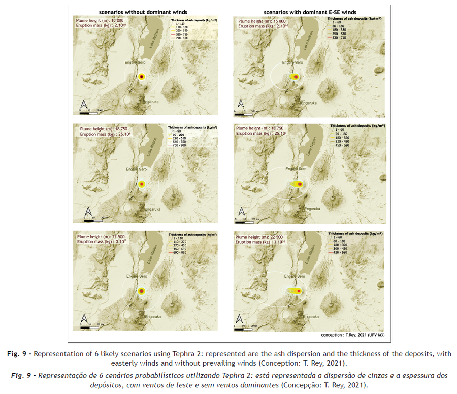
Figure in a journal article
Representation of 6 likely scenarios using Tephra 2: represented are the ash dispersion and the thickness of the deposits, with easterly winds and without prevailing winds
Figure 9 in: Rey, T., Leone, F., Defossez, S., Gherardi, M., & Parat, F. (2021). Volcanic hazards assessment of Ol Doinyo Lengai in a data scarcity context (Tanzania). Territorium, (28 (II)), 69-81.
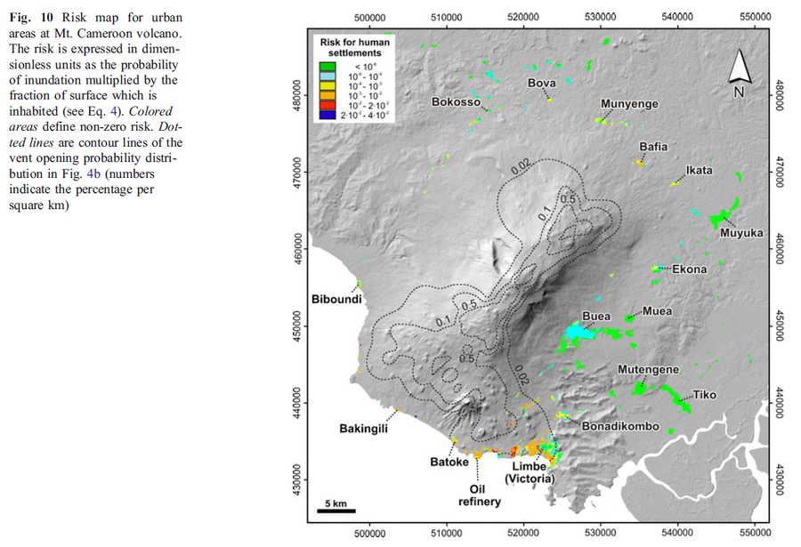
Figure in a journal article
Risk map for urban areas at Mt. Cameroon volcano
Figure 10 in: Favalli, M., Tarquini, S., Papale, P., Fornaciai, A., & Boschi, E. (2012). Lava flow hazard and risk at Mt. Cameroon volcano. Bulletin of Volcanology, 74(2), 423-439. https://doi.org/10.1007/s00445-011-0540-6