
Advanced Search for Maps
Showing 1-10 of 36
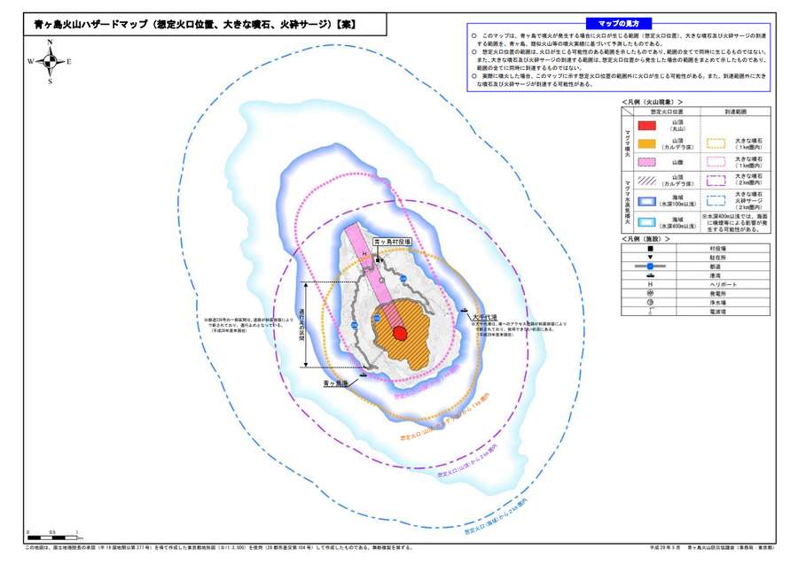
Official, Map sheet or poster
Aogashima volcanic hazard map (assumed crater position, volcanic blocks, pyroclastic surge)
Aogashima Volcano Disaster Prevention Council. (2017). Aogashima volcanic hazard map. Disaster Prevention Division, Bureau of General Affairs, Tokyo Metropolitan Government.
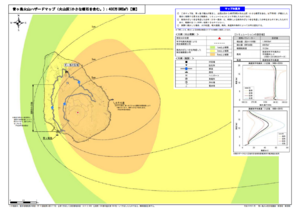
Official, Map sheet or poster
Aogashima volcano hazard map (volcanic ash (including volcanic lapilli): 4 million m³ DRE)
Aogashima Volcano Disaster Prevention Council. (2017). Aogashima volcanic hazard map. Disaster Prevention Division, Bureau of General Affairs, Tokyo Metropolitan Government.
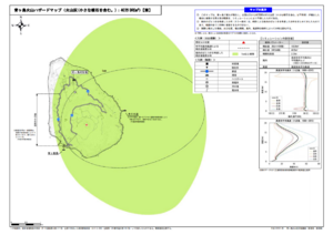
Official, Map sheet or poster
Aogashima volcano hazard map (volcanic ash (including volcanic lapilli): 400,000 m³ DRE)
Aogashima Volcano Disaster Prevention Council. (2017). Aogashima volcanic hazard map. Disaster Prevention Division, Bureau of General Affairs, Tokyo Metropolitan Government.
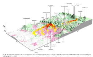
Figure in a journal article
Block diagram appraisal of the two event scenario
Figure 9 in: Latutrie, B., Andredakis, I., De Groeve, T., Harris, A. J. L., Langlois, E., de Vries, B. V. W., Saubin, E., Bilotta, G., Cappello, A., Crisci, G.M., D'ambrosio, D., Del Negro, C., Favalli, M., Fujita, E., Iovine, G., Kelfoun, K., Rongo, R., Spataro, W., Tarquini, S., Coppola, D., Ganci, G., Marchese, F., Pergola, N., & Tramutoli, V. (2016). Testing a geographical information system for damage and evacuation assessment during an effusive volcanic crisis. In: Harris, A.J.L., De Groeve, T., & Carn, S.A. (Eds.) Detecting, Modelling and Responding to Effusive Eruptions. Geological Society, London, Special Publications, 426(1), p. 649-672. https://doi.org/10.1144/SP426.19
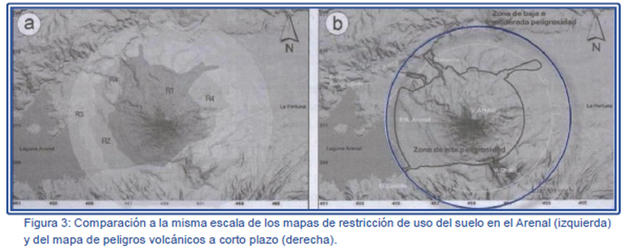
Figure in a journal article
Comparación a la misma escala de los mapas de restricción de uso del suelo en el Arenal (izquierda) y del mapa de peligros volcánicos a corto plazo (derecha).
(Comparison at the same scale of the Arenal land use restriction maps (left) and the short-term volcanic hazard map (right).)
Figure 3 in: Soto, G.J. & Sjöbohm, L. (2007). Los Peligros volcánicos del Arenal. En torno a la Prevencion. Revista No. 4, Junio 2007. Comisión Nacional de Prevención de Riesgos y Atención de Emergencias (CNE).
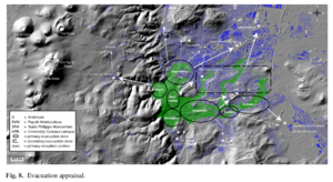
Figure in a journal article
Evacuation appraisal
Figure 8 in: Latutrie, B., Andredakis, I., De Groeve, T., Harris, A. J. L., Langlois, E., de Vries, B. V. W., Saubin, E., Bilotta, G., Cappello, A., Crisci, G.M., D'ambrosio, D., Del Negro, C., Favalli, M., Fujita, E., Iovine, G., Kelfoun, K., Rongo, R., Spataro, W., Tarquini, S., Coppola, D., Ganci, G., Marchese, F., Pergola, N., & Tramutoli, V. (2016). Testing a geographical information system for damage and evacuation assessment during an effusive volcanic crisis. In: Harris, A.J.L., De Groeve, T., & Carn, S.A. (Eds.) Detecting, Modelling and Responding to Effusive Eruptions. Geological Society, London, Special Publications, 426(1), p. 649-672. https://doi.org/10.1144/SP426.19
Official, Figure in hazard assessment
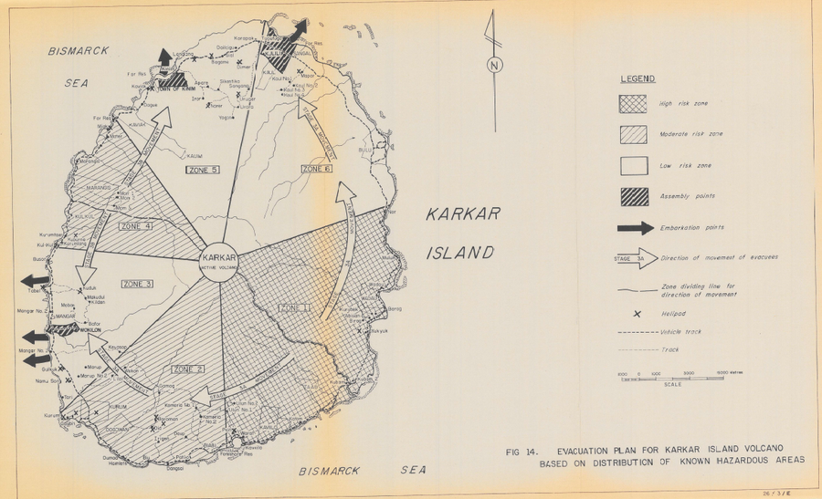
Evacuation Plan for Karkar Island Volcano Based on Distribution of Known Hazardous Areas
Figure 14 in: Lowenstein, P.L. (1982). Problems of volcanic hazards in Papua New Guinea. Geological Survey of Papua New Guinea, Report 82/7, 62 p.
Official, Unknown format
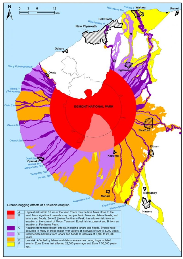
Ground hugging effects of a volcanic eruption
Taranaki Regional Council. (2004). Civil Defence Emergency Management, Group Plan for Taranaki. Stratford.
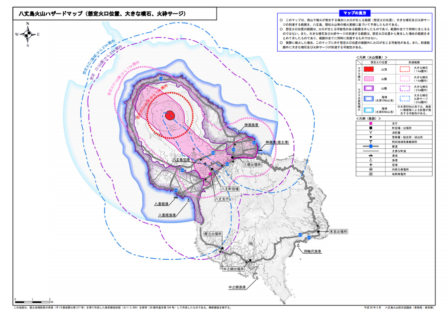
Official, Map sheet or poster
Hachijojima volcano hazard map (assumed crater position, volcanic blocks, pyroclastic surge)
Hachijojima Volcano Disaster Prevention Council. (2017). Hachijojima volcano hazard map. Disaster Prevention Division, Bureau of General Affairs, Tokyo Metropolitan Government.
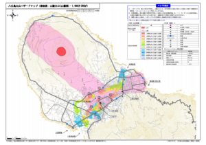
Official, Map sheet or poster
Hachijojima Volcano Hazard Map (Lava flow: Flank craters (base of volcano), 16 million m³ DRE)
Hachijojima Volcano Disaster Prevention Council. (2017). Hachijojima volcano hazard map. Disaster Prevention Division, Bureau of General Affairs, Tokyo Metropolitan Government.