
Advanced Search for Maps
Showing 1-10 of 385
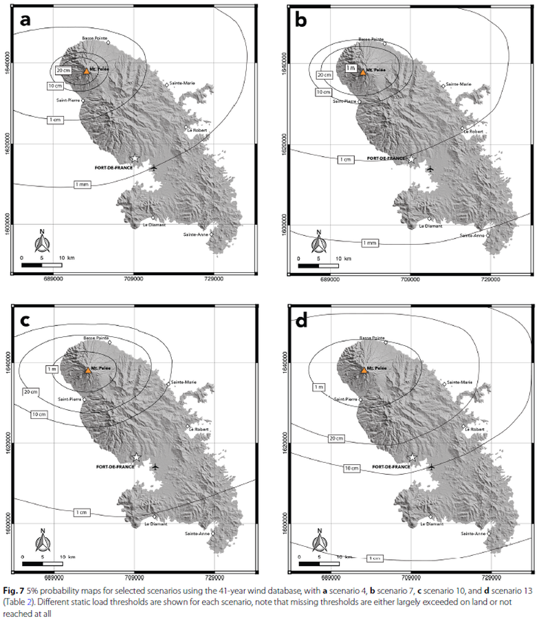
Figure in a journal article
5% probability maps for selected scenarios
Figure 7 in: Michaud-Dubuy, A., Carazzo, G., & Kaminski, E. (2021). Volcanic hazard assessment for tephra fallout in Martinique. Journal of Applied Volcanology, 10(1), 1-20. https://doi.org/10.1186/s13617-021-00106-7.

Figure in a journal article
Absolute probability for areas to be affected by a ballistic impact density >0.001
Figure 12 in: Strehlow, K., Sandri, L., Gottsmann, J. H., Kilgour, G., Rust, A. C., & Tonini, R. (2017). Phreatic eruptions at crater lakes: occurrence statistics and probabilistic hazard forecast. Journal of Applied Volcanology, 6(1), 4. https://doi.org/10.1186/s13617-016-0053-2
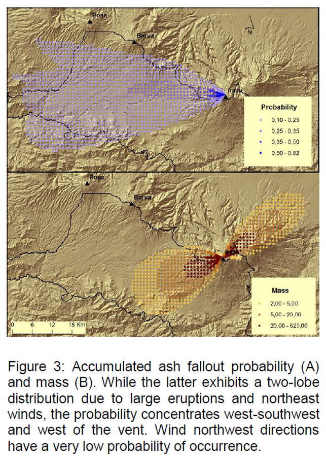
Figure in a journal article
Accumulated ash fallout probability and mass
Figure 3 in: Barrantes, G., Núñez, S., & Malavassi, E. (2018). Ash fallout hazard from Irazú volcano, Costa Rica. Revista Geográfica de Chile Terra Australis, 54(1), 13-25. https://doi.org/10.23854/07199562.2018541Barrantes13
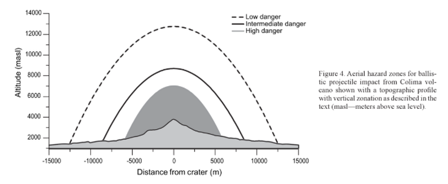
Figure in a journal article
Aerial hazard zones for ballistic impact from Colima volcano shown with a topographic profile with vertical zonation as described in the text
Figure 4 in: Alatorre-Ibargüengoitia, M.A., Delgado-Granados, H., & Farraz-Montes, I.A. (2006). Hazard zoning for ballistic impact during volcanic explosions at Volcán de Fuego de Colima (México). In: Siebe, C., Macías Gerardo, J.L., Aguirre-Díaz, J. (Eds.). Neogene-Quaternary Continental Margin Volcanism: A perspective from México. Geological Society of America, Special Papers 402, p. 209-216. https://doi.org/10.1130/2006.2402(09)
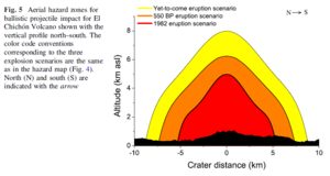
Figure in a journal article
Aerial hazard zones for ballistic projectile impact for El Chichón Volcano shown with the vertical profile north–south
Figure 5 in: Alatorre-Ibargüengoitia, M.A., Morales-Iglesias, H., Ramos-Hernández, S.G., Jon-Selvas, J., & Jiménez-Aguilar, J.M. (2016). Hazard zoning for volcanic ballistic impacts at El Chichón Volcano (Mexico). Natural Hazards, 81(3), p. 1733-1744. https://doi.org/10.1007/s11069-016-2152-0
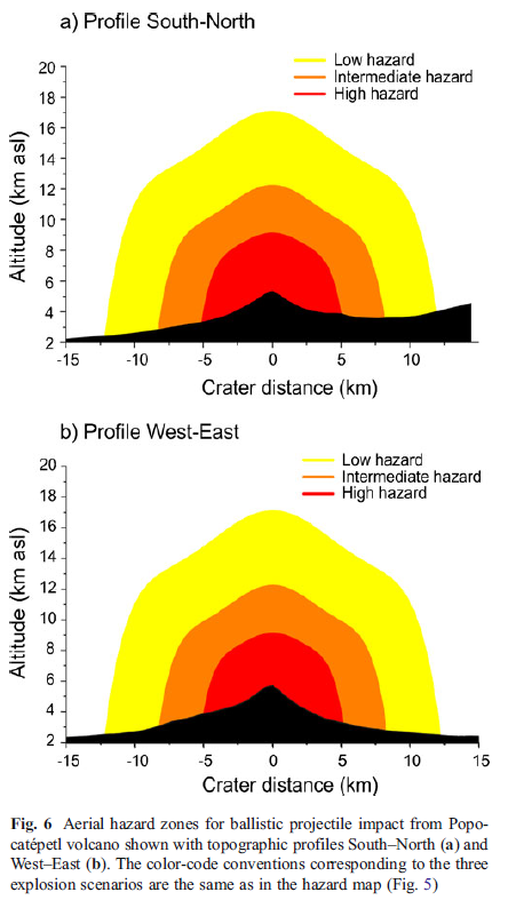
Figure in a journal article
Aerial hazard zones for ballistic projectile impact from Popocatépetl volcano shown with topographic profiles
Figure 6 in: Alatorre-Ibargüengoitia, M. A., Delgado-Granados, H., & Dingwell, D. B. (2012). Hazard map for volcanic ballistic impacts at Popocatépetl volcano (Mexico). Bulletin of Volcanology, 74(9), p. 2155-2169. https://doi.org/10.1007/s00445-012-0657-2
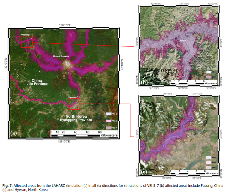
Figure in a journal article
Affected areas from the LAHARZ simulation
Figure 7 in: Achmad, A.R., Lee, S., Park, S. Eom, J., & Lee, C.-W. (2020). Estimating the potential risk of the Mt. Baekdu Volcano using a synthetic interferogram and the LAHARZ inundation zone. Geosciences Journal. 24, 755–768. https://doi.org/10.1007/s12303-020-0032-9
Santiaguito (Santa María), Guatemala
Figure in a journal article
Amenaza de Flujos Piroclásticos Volcán Santiaguito, Guatemala
(Threat of Pyroclastic Flows Santiaguito Volcano, Guatemala)
Figure 4 in: Barillas-Cruz, M., van Westen, C., Orozco, E., Thonon, I., Lira, E., Guarín, G. P., & Tax, P. (2003). Zonificación de amenazas naturales en la cuenca del Río Samalá y análisis de vulnerabilidad y riesgo en la población de San Sebastián Retalhuleu, Guatemala. Retalhuleu, Guatemala: GEOS, 23(1), p. 17-24.
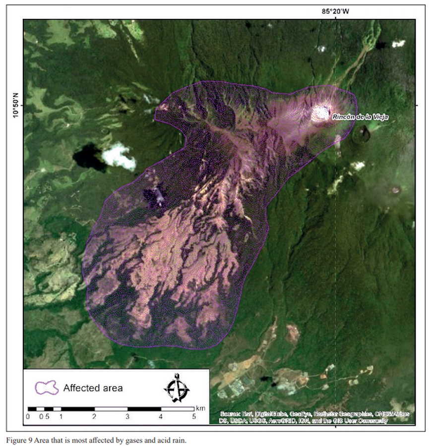
Figure in a journal article
Area that is most affected by gases and acid rain
Figure 9 in: Alpízar, Y., Fernández, M., Ramírez, C., & Arroyo, D. (2019). Hazard Map of Rincón de la Vieja Volcano, Costa Rica: Qualitative Integration of Computer Simulations and Geological Data. Anuario do Instituto de Geociencias, 42(3). http://dx.doi.org/10.11137/2019_3_474_488
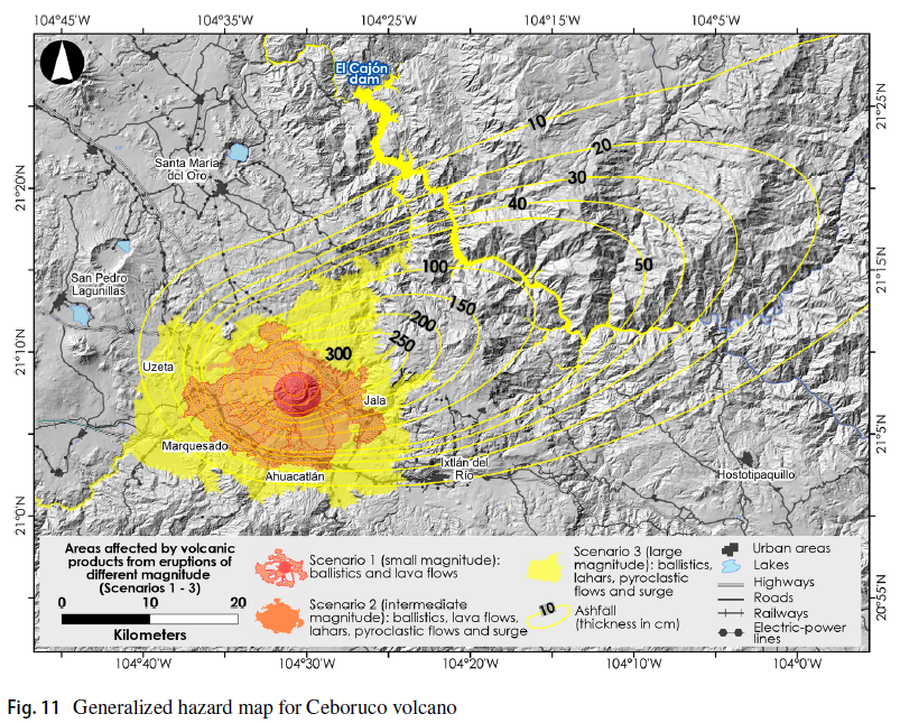
Figure in a journal article
Areas affected by volcanic products from eruptions of different magnitude (Scenarios 1-3)
Figure 11 in: Sieron, K., Ferrés, D., Siebe, C., Constantinescu, R., Capra, L., Connor, C., Connor, L., Groppelli, G. & Zuccolotto, K.G. (2019). Ceboruco hazard map: part II—modeling volcanic phenomena and construction of the general hazard map. Natural Hazards, 96(2), p. 893-933. https://doi.org/10.1007/s11069-019-03577-5