
Advanced Search for Maps
Showing 1-10 of 256
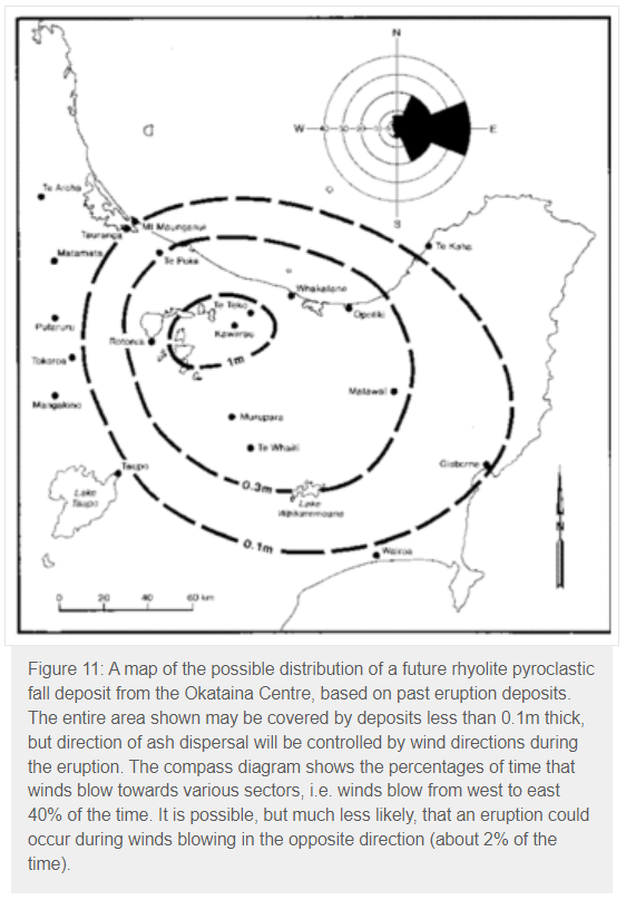
Official, Figure in hazard assessment
A map of the possible distribution of a future rhyolite pyroclastic fall deposit from the Okataina Centre, based on past eruption deposits
Figure 11 in: Nairn, I.A. (1993). Volcanic hazards at Okataina Centre. 3rd ed. Ministry of Civil Defence, Palmerston North, NZ. Volcanic hazards information series 2. 29 p. Reproduced on website: https://www.gns.cri.nz/Home/Learning/Science-Topics/Volcanoes/New-Zealand-Volcanoes/Volcano-Geology-and-Hazards/Okataina-Volcanic-Centre-Geology
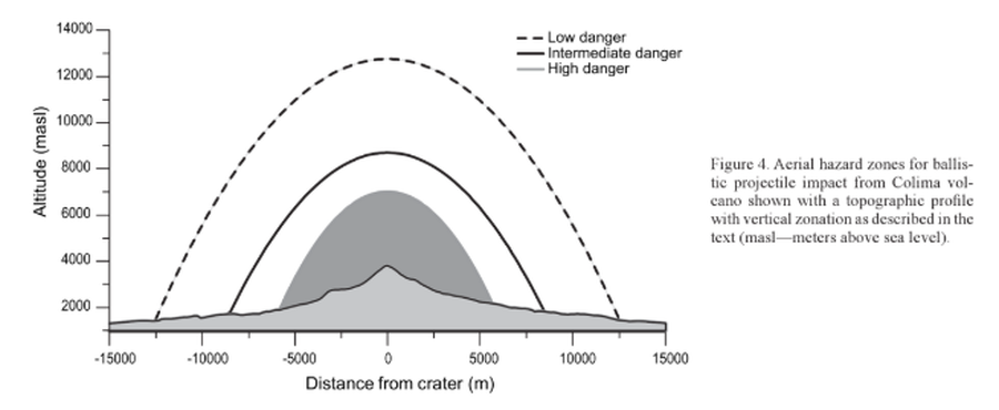
Figure in a journal article
Aerial hazard zones for ballistic impact from Colima volcano shown with a topographic profile with vertical zonation as described in the text
Figure 4 in: Alatorre-Ibargüengoitia, M.A., Delgado-Granados, H., & Farraz-Montes, I.A. (2006). Hazard zoning for ballistic impact during volcanic explosions at Volcán de Fuego de Colima (México). In: Siebe, C., Macías Gerardo, J.L., Aguirre-Díaz, J. (Eds.). Neogene-Quaternary Continental Margin Volcanism: A perspective from México. Geological Society of America, Special Papers 402, p. 209-216. https://doi.org/10.1130/2006.2402(09)
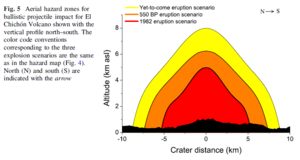
Figure in a journal article
Aerial hazard zones for ballistic projectile impact for El Chichón Volcano shown with the vertical profile north–south
Figure 5 in: Alatorre-Ibargüengoitia, M.A., Morales-Iglesias, H., Ramos-Hernández, S.G., Jon-Selvas, J., & Jiménez-Aguilar, J.M. (2016). Hazard zoning for volcanic ballistic impacts at El Chichón Volcano (Mexico). Natural Hazards, 81(3), p. 1733-1744. https://doi.org/10.1007/s11069-016-2152-0
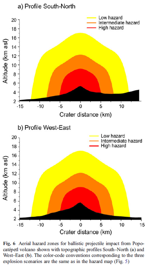
Figure in a journal article
Aerial hazard zones for ballistic projectile impact from Popocatépetl volcano shown with topographic profiles
Figure 6 in: Alatorre-Ibargüengoitia, M. A., Delgado-Granados, H., & Dingwell, D. B. (2012). Hazard map for volcanic ballistic impacts at Popocatépetl volcano (Mexico). Bulletin of Volcanology, 74(9), p. 2155-2169. https://doi.org/10.1007/s00445-012-0657-2
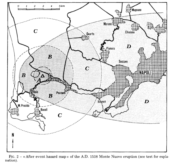
Figure in a journal article
After event hazard map of the A.D. 1538 Monte Nuevo eruption
Figure 2 in: Rosi, M., & Santacroce, R. (1984). Volcanic hazard assessment in the Phlegraean Fields: a contribution based on stratigraphic and historical data. Bulletin Volcanologique, 47(2), p. 359-370. https://doi.org/10.1007/BF01961567
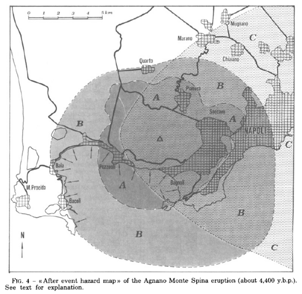
Figure in a journal article
After event hazard map of the Agnano Monte Spina eruption (about 4,400 y.b.p.)
Figure 4 in: Rosi, M. & Santacroce, R. (1984). Volcanic hazard assessment in the Phlegraean Fields: a contribution based on stratigraphic and historical data. Bulletin Volcanologique, 47(2), p. 359-370. https://doi.org/10.1007/BF01961567
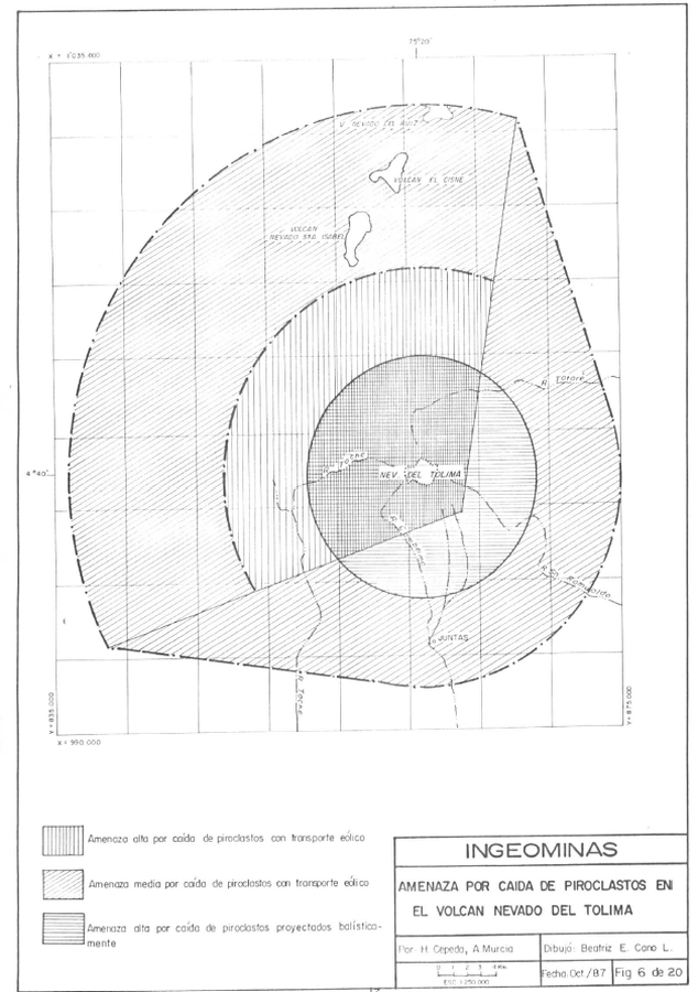
Official, Figure in hazard assessment
Amenaza por Caida de Piroclastos en el Volcan Nevado del Tolima
(Hazards from the Fall of Pyroclasts at Nevado del Tolima Volcano)
Figure 6 in: Cepeda, H. & Murcia, A. (1988). Mapa Preliminar de Amenaza Volcanica Potencial del Nevado del Tolima, Colombia, S.A. INGEOMINAS, Instituto Nacional de Investigaciones Geologico-Mineras. Medellin.
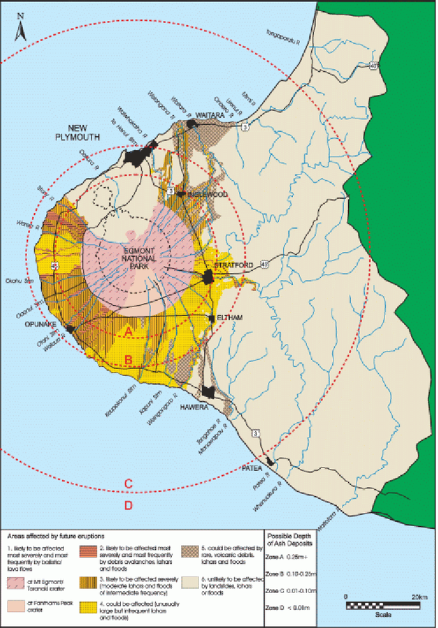
Official, Figure in a journal article
An example of a volcanic hazard map for Mount Taranaki
Figure 2 in: Becker, J.S., Saunders, W.S.A., Robertson, C.M., Leonard, G.S., & Johnston, D.M. (2010). A synthesis of challenges and opportunities for reducing volcanic risk through land use planning in New Zealand. The Australasian Journal of Disaster and Trauma Studies, 2010-1. (Simplified from: Taranaki Regional Council 2004)
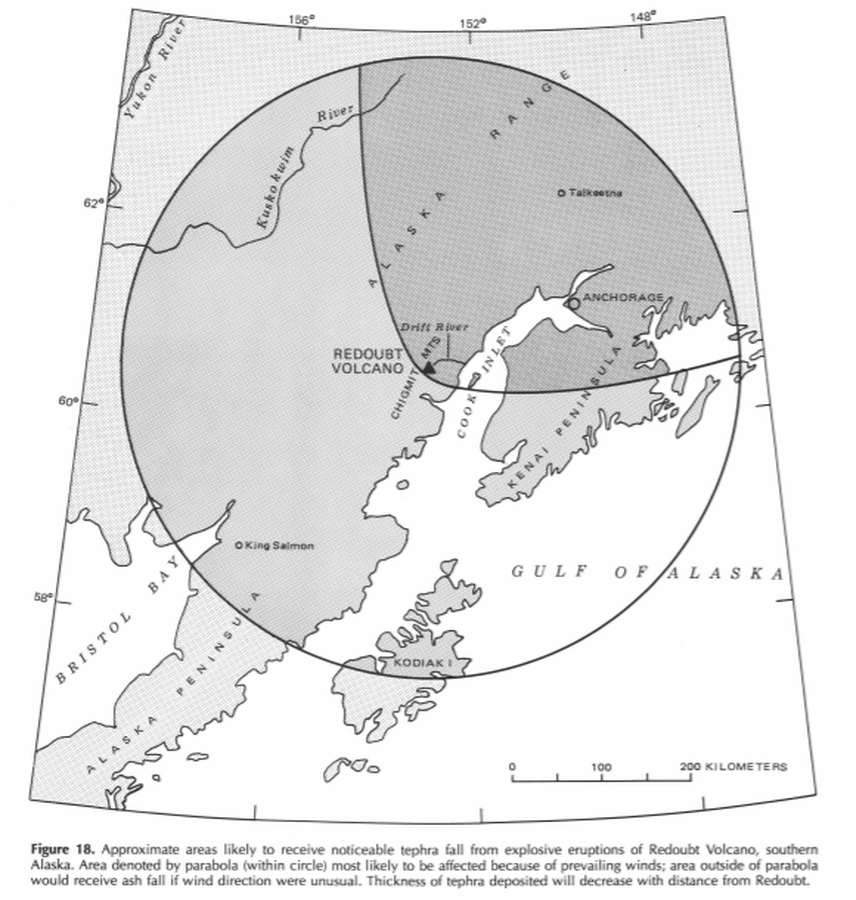
Official, Figure in hazard assessment
Approximate areas likely to receive noticeable tephra fall from explosive eruptions of Redoubt Volcano, southern Alaska
Figure 18 in: Till, A.B., Yount, M.E., & Riehle, J.R. (1993). Redoubt Volcano, southern Alaska; a hazard assessment based on eruptive activity through 1968. U.S. Geological Survey, Bulletin 1996, 19 p., 1 plate. https://doi.org/10.3133/b1996
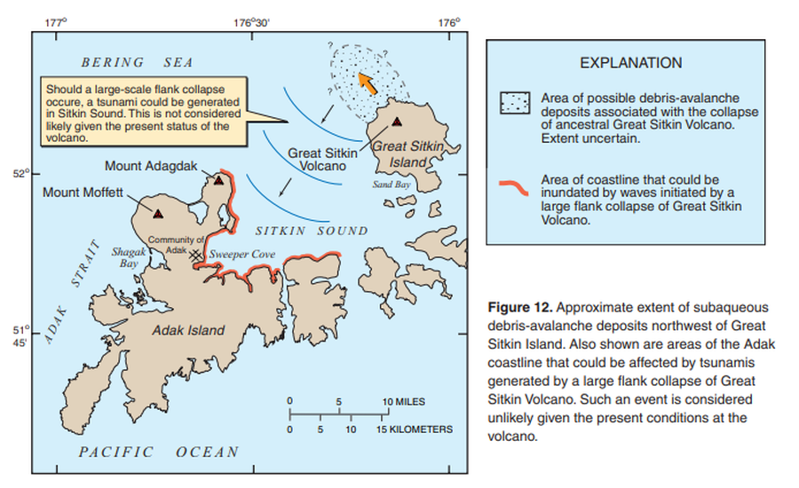
Official, Figure in hazard assessment
Approximate extent of subaqueous debris-avalanche deposits northwest of Great Sitkin Island. Also shown are areas of Adak coastline that could be affected by tsunamis generated by a large flank collapse of Great Sitkin Volcano.
Figure 12 in: Waythomas, C.F., Miller, T.P. & Nye, C.J. (2003). Preliminary volcano-hazard assessment for Great Sitkin Volcano, Alaska. U.S. Geological Survey, Open-File Report 03-112, 25 p., 1 plate. https://doi.org/10.3133/ofr03112