
Advanced Search for Maps
Showing 1-10 of 391
Official, Map in an information statement
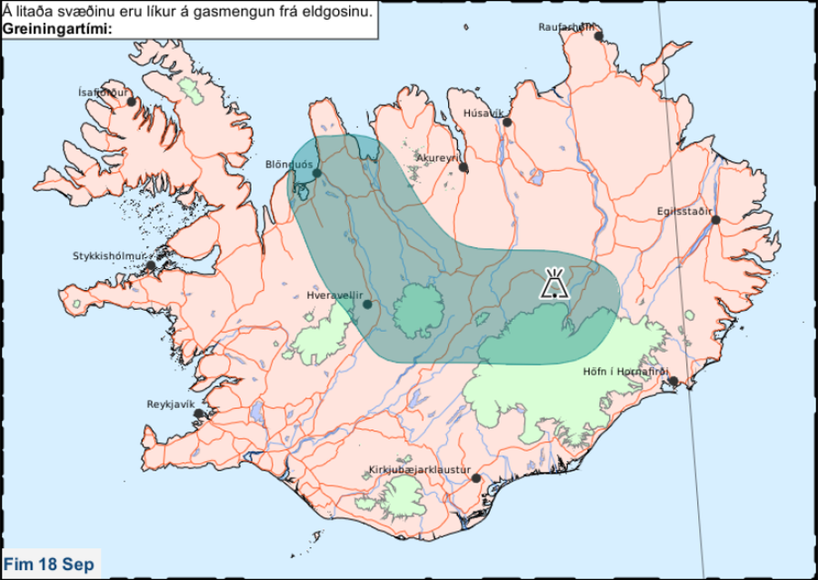
Á litaða svæðinu eru líkur á gasmengun frá eldgosinu. Fim 18 Sep.
(In the colored area there is a likelihood of gas pollution from the eruption. Thu 18 Sep.)
Iceland Meteorological Office (IMO). (2014). Á litaða svæðinu eru líkur á gasmengun frá eldgosinu. Fim 18 Sep.
Official, Flyer, brochure, short fact-sheet, or handout
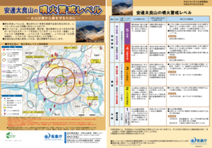
Adatarayama Volcanic Alert Levels
Japan Meteorological Agency. (2019). Adatarayama Volcanic Alert Levels. Volcano Monitoring and Warning Center, Volcano Division, Earthquake and Volcano Department.
Official, Flyer, brochure, short fact-sheet, or handout
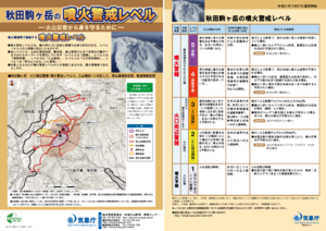
Akita-Komagatake Volcanic Alert Levels
Japan Meteorological Agency. (2016). Akita-Komagatake Volcanic Alert Levels. Volcano Monitoring and Warning Center, Volcano Division, Earthquake and Volcano Department.
Official, Flyer, brochure, short fact-sheet, or handout
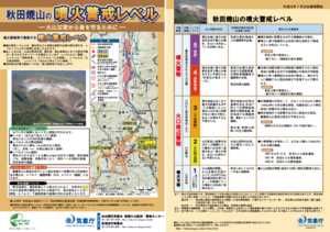
Akita-Yakeyama Volcanic Alert Levels
Japan Meteorological Agency. (2016). Akita-Yakeyama Volcanic Alert Levels. Volcano Monitoring and Warning Center, Volcano Division, Earthquake and Volcano Department.
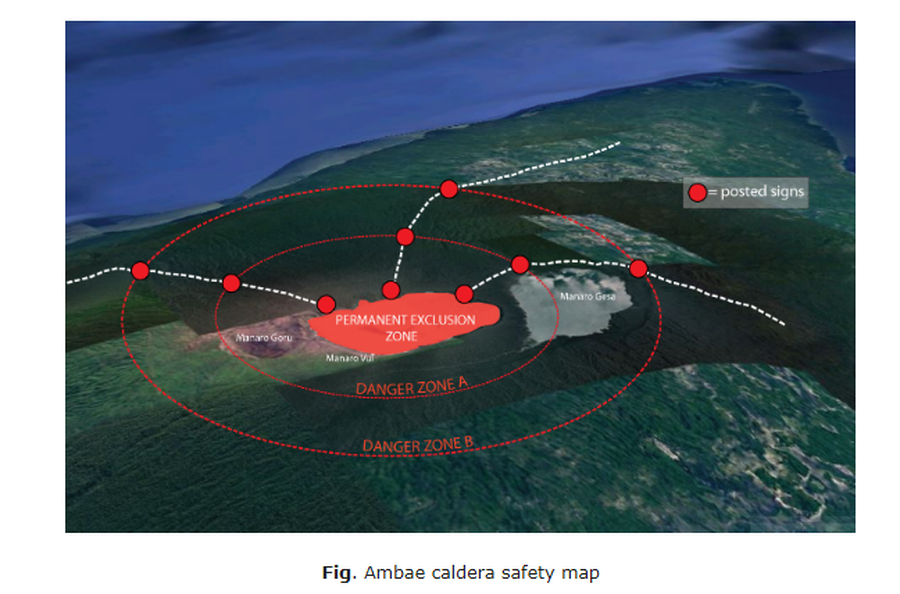
Official, Map in an information statement
Ambae caldera safety map
Figure 1 in: Vanuatu Meteorology & Geo-Hazards Department. (2020). Vanuatu Volcano Alert Bulletin No. 4 - Ambae Activity, Thursday May 28th 2020.
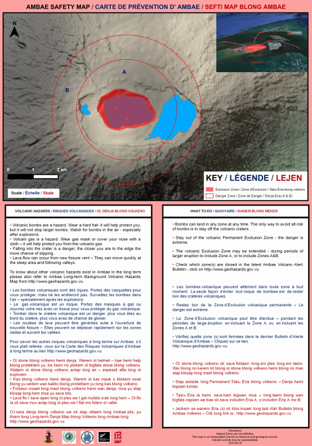
Official, Map sheet or poster
Ambae Safety Map
Vanuatu Meteorology & Geo-Hazards Department. (2019). Ambae Safety Map. Government of Vanuatu, Vanuatu Meteorology & Geo-Hazards Department, Vanuatu National Disaster Risk Management Office, New Zealand Foreign Affairs & Trade Aid Programme, GNS Science.
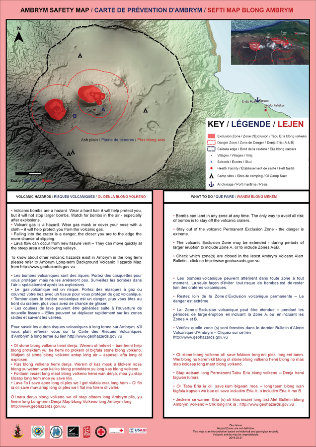
Official, Map sheet or poster
Ambrym Safety Map
Vanuatu Meteorology & Geo-Hazards Department. (2016). Ambrym Safety Map. Government of Vanuatu, Vanuatu Meteorology & Geo-Hazards Department, Vanuatu National Disaster Risk Management Office, New Zealand Foreign Affairs & Trade Aid Programme, GNS Science.
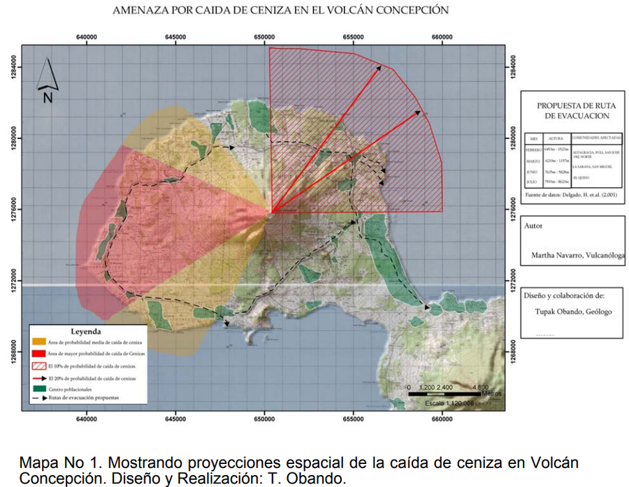
Figure in hazard assessment
Amenaza por Caida de Ceniza en el Volcán Concepción
(Threat due to Ash Fall in the Concepción Volcano)
Mapa 1 in: Obando, T. & Navarro, M. (2009). Propuestade Rutas de Evacuación ante peligros por Caída de Cenizas y Flujos Piroclásticos en la Isla de Ometepe (Rivas, Nicaragua). https://1library.co/document/y621ejgz-propuesta-evacuacion-peligros-caida-cenizas-piroclasticos-ometepe-nicaragua.html
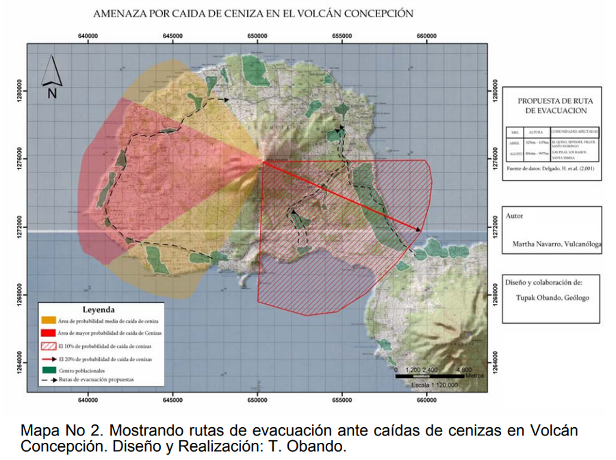
Figure in hazard assessment
Amenaza por Caida de Ceniza en el Volcán Concepción
(Threat due to Ash Fall in the Concepción Volcano)
Mapa 2 in: Obando, T. & Navarro, M. (2009). Propuestade Rutas de Evacuación ante peligros por Caída de Cenizas y Flujos Piroclásticos en la Isla de Ometepe (Rivas, Nicaragua). https://1library.co/document/y621ejgz-propuesta-evacuacion-peligros-caida-cenizas-piroclasticos-ometepe-nicaragua.html
Figure in hazard assessment
Amenaza por Caida de Ceniza en el Volcán Concepción
(Threat due to Ash Fall in the Concepción Volcano)
Obando, T. & Navarro, M. (2009). Propuestade Rutas de Evacuación ante peligros por Caída de Cenizas y Flujos Piroclásticos en la Isla de Ometepe (Rivas, Nicaragua). https://1library.co/document/y621ejgz-propuesta-evacuacion-peligros-caida-cenizas-piroclasticos-ometepe-nicaragua.html