
Advanced Search for Maps
Showing 1-10 of 240
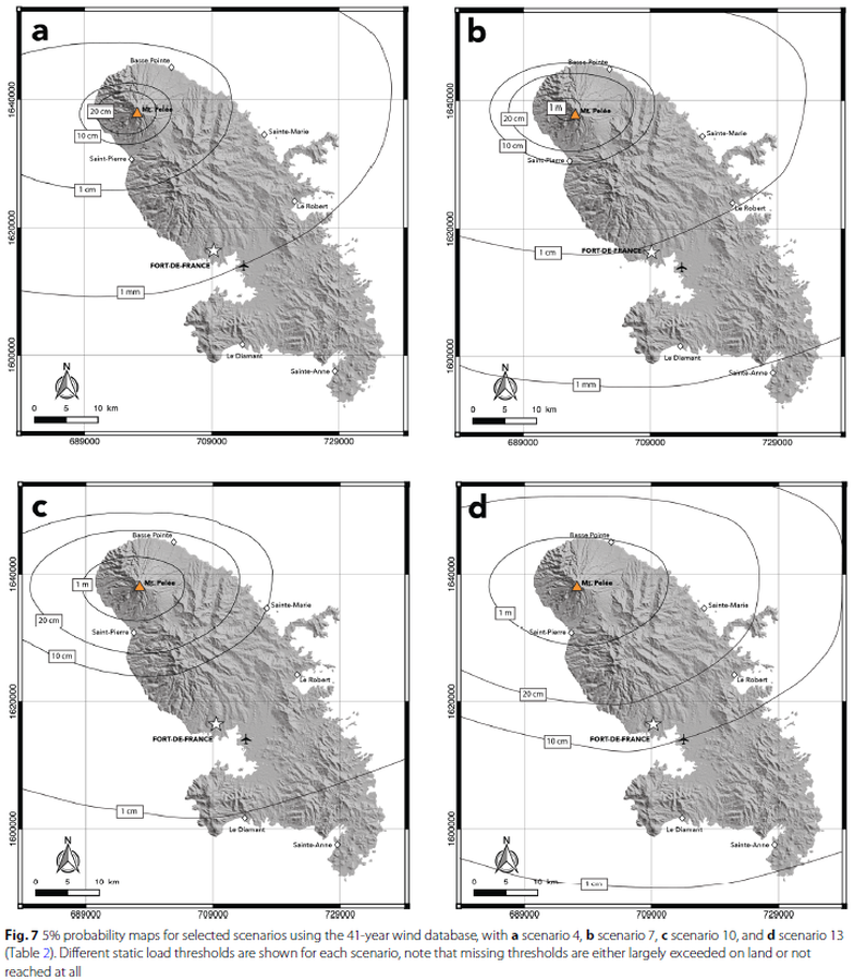
Figure in a journal article
5% probability maps for selected scenarios
Figure 7 in: Michaud-Dubuy, A., Carazzo, G., & Kaminski, E. (2021). Volcanic hazard assessment for tephra fallout in Martinique. Journal of Applied Volcanology, 10(1), 1-20. https://doi.org/10.1186/s13617-021-00106-7.
Official, Map in an information statement
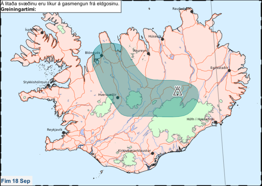
Á litaða svæðinu eru líkur á gasmengun frá eldgosinu. Fim 18 Sep.
(In the colored area there is a likelihood of gas pollution from the eruption. Thu 18 Sep.)
Iceland Meteorological Office (IMO). (2014). Á litaða svæðinu eru líkur á gasmengun frá eldgosinu. Fim 18 Sep.
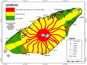
Figure in a journal article
Ambae
Cronin, S.J., Gaylord, D.R., Charley, D., Alloway, B.V., Wallez, S., & Esau, J.W. (2004). Participatory methods of incorporating scientific with traditional knowledge for volcanic hazard management on Ambae Island, Vanuatu. Bulletin of volcanology, 66(7), p. 652-668. https://doi.org/10.1007/s00445-004-0347-9. (Reprinted in: Cronin, S. J., & Németh, K., Stewart, R.B. (2006). Volcanic hazards planning on rifting island and fissure volcanoes. Joint Conference of the Geological Society of New Zealand and the New Zealand Geophysical Society.)
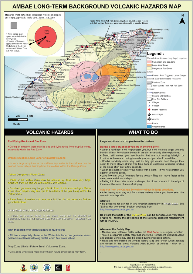
Official, Map sheet or poster
Ambae Long-Term Background Volcanic Hazards Map
Vanuatu Meteorology & Geo-Hazards Department. (2019). Ambae Long-Term Background Volcanic Hazards Map. Government of Vanuatu, Vanuatu Meteorology & Geo-Hazards Department, Vanuatu National Disaster Risk Management Office, New Zealand Foreign Affairs & Trade Aid Programme, GNS Science.
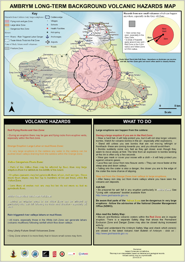
Official, Map sheet or poster
Ambrym Long-Term Background Volcanic Hazards Map
Vanuatu Meteorology & Geo-Hazards Department. (2016). Ambrym Long-Term Background Volcanic Hazards Map. Government of Vanuatu, Vanuatu Meteorology & Geo-Hazards Department, Vanuatu National Disaster Risk Management Office, New Zealand Foreign Affairs & Trade Aid Programme, GNS Science, The Vanuatu Red Cross Society, Croix Rouge Francaise, USAID.
Official, Flyer, brochure, short fact-sheet, or handout
Aogashima Volcanic Alert Levels
Japan Meteorological Agency. (2018). Aogashima Volcanic Alert Levels. Volcano Monitoring and Warning Center, Volcano Division, Earthquake and Volcano Department.
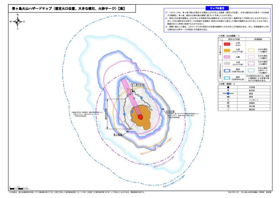
Official, Map sheet or poster
Aogashima volcanic hazard map (assumed crater position, volcanic blocks, pyroclastic surge)
Aogashima Volcano Disaster Prevention Council. (2017). Aogashima volcanic hazard map. Disaster Prevention Division, Bureau of General Affairs, Tokyo Metropolitan Government.
Official, Map sheet or poster
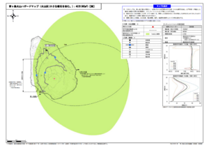
Aogashima volcano hazard map (volcanic ash (including volcanic lapilli): 4 million m³ DRE)
Aogashima Volcano Disaster Prevention Council. (2017). Aogashima volcanic hazard map. Disaster Prevention Division, Bureau of General Affairs, Tokyo Metropolitan Government.
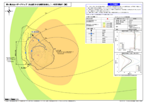
Official, Map sheet or poster
Aogashima volcano hazard map (volcanic ash (including volcanic lapilli): 400,000 m³ DRE)
Aogashima Volcano Disaster Prevention Council. (2017). Aogashima volcanic hazard map. Disaster Prevention Division, Bureau of General Affairs, Tokyo Metropolitan Government.
Official, Figure in hazard assessment
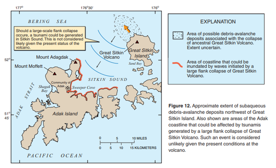
Approximate extent of subaqueous debris-avalanche deposits northwest of Great Sitkin Island. Also shown are areas of Adak coastline that could be affected by tsunamis generated by a large flank collapse of Great Sitkin Volcano.
Figure 12 in: Waythomas, C.F., Miller, T.P. & Nye, C.J. (2003). Preliminary volcano-hazard assessment for Great Sitkin Volcano, Alaska. U.S. Geological Survey, Open-File Report 03-112, 25 p., 1 plate. https://doi.org/10.3133/ofr03112