
Advanced Search for Maps
Showing 221-230 of 2217
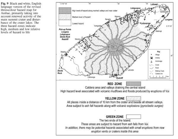
Figure in a journal article
Black and white, English language version of the revised three-colour hazard map for Ambae, primarily taking into account renewed activity of the main summit crater and disturbance of the crater lakes
Figure 9 in: Cronin, S.J., Gaylord, D.R., Charley, D., Alloway, B.V., Wallez, S., & Esau, J.W. (2004). Participatory methods of incorporating scientific with traditional knowledge for volcanic hazard management on Ambae Island, Vanuatu. Bulletin of volcanology, 66(7), p. 652-668. https://doi.org/10.1007/s00445-004-0347-9
Official, Map in an information statement
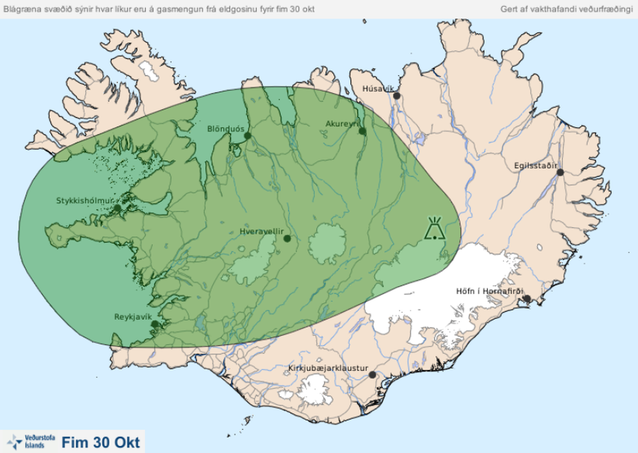
Blágræna svæðið sýnir hvar líkur eru á gasmengun frá eldgosinu fyrir fim 30 okt
(The blue-green area shows the probability of gas pollution from the volcanic eruption before Oct. 30)
Iceland Meteorological Office (IMO). (2014). Blágræna svæðið sýnir hvar líkur eru á gasmengun frá eldgosinu fyrir fim 30 okt
Official, Map in an information statement
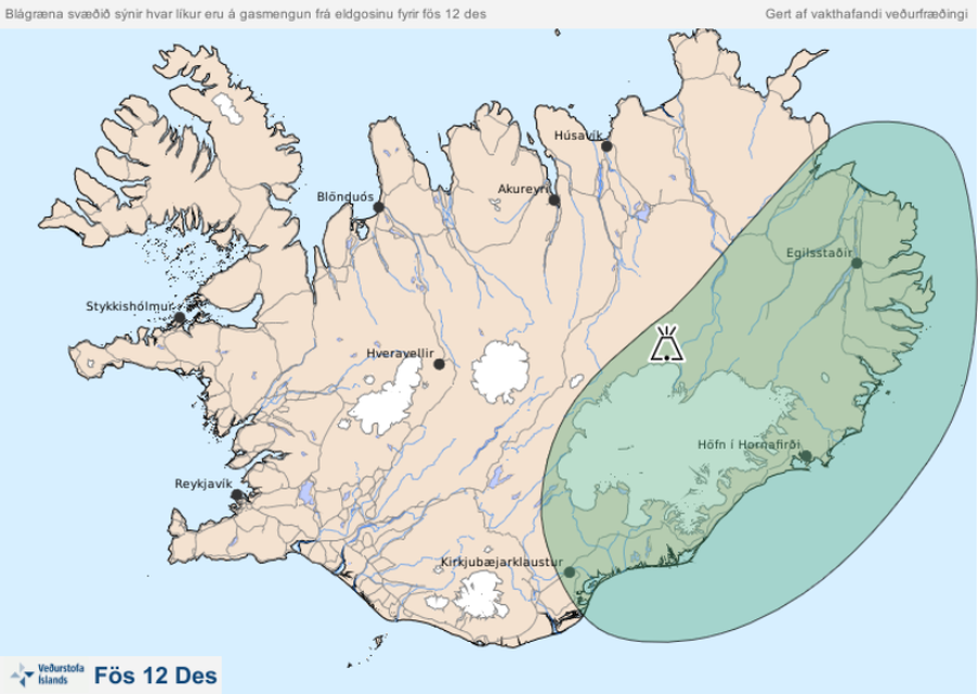
Blágræna svæðið sýnir hvar líkur eru á gasmengun frá eldgosinu fyrir fös 12 des
(The blue-green area shows the probability of gas pollution from the eruption before Fri Dec 12)
Iceland Meteorological Office (IMO). (2014). Blágræna svæðið sýnir hvar líkur eru á gasmengun frá eldgosinu fyrir fös 12 des
Official, Map in an information statement
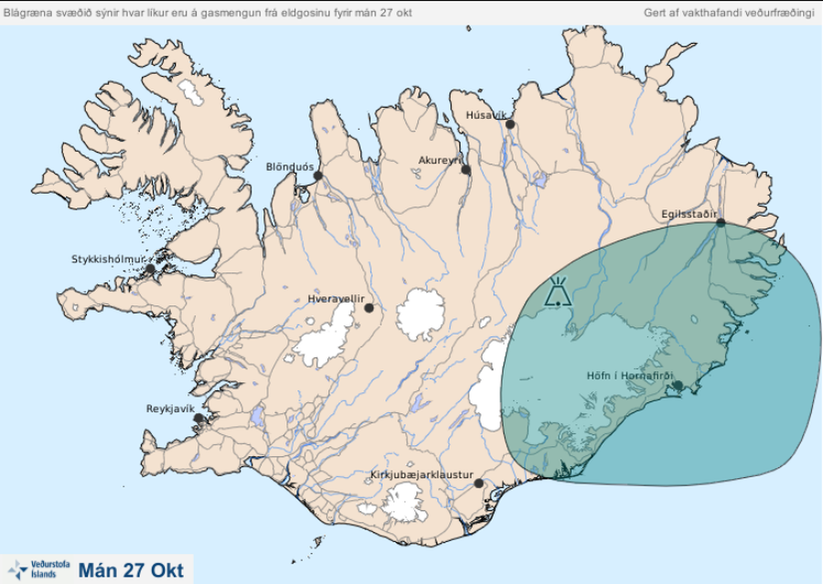
Blágræna svæðið sýnir hvar líkur eru á gasmengun frá eldgosinu fyrir mán 27 okt
(The blue-green area shows the likelihood of gas pollution from the eruption before Mon Oct 27)
Iceland Meteorological Office (IMO). (2014). Blágræna svæðið sýnir hvar líkur eru á gasmengun frá eldgosinu fyrir mán 27 okt
Official, Map in an information statement
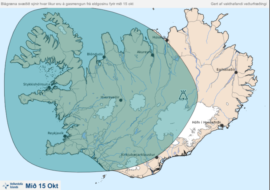
Blágræna svæðið sýnir hvar líkur eru á gasmengun frá eldgosinu fyrir mið 15 okt.
(The blue-green area shows the probability of gas pollution from the volcanic eruption by mid-15 oct.)
Iceland Meteorological Office (IMO). (2014). Blágræna svæðið sýnir hvar líkur eru á gasmengun frá eldgosinu fyrir mið 15 okt.
Official, Map in an information statement
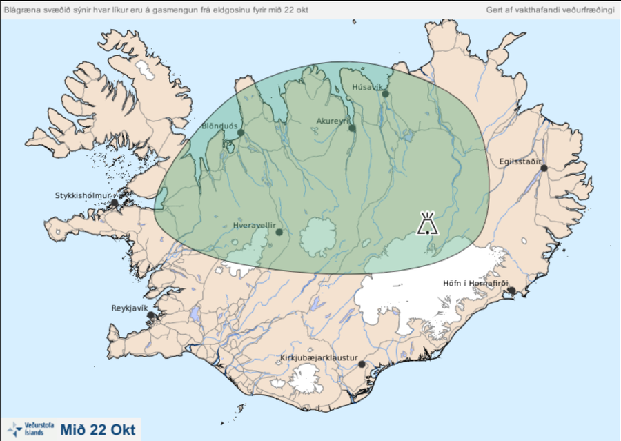
Blágræna svæðið sýnir hvar líkur eru á gasmengun frá eldgosinu fyrir mið 22 okt.
(The blue-green area shows the probability of gas pollution from the eruption by mid-22 October.)
Iceland Meteorological Office (IMO). (2014). Blágræna svæðið sýnir hvar líkur eru á gasmengun frá eldgosinu fyrir mið 22 okt.
Official, Map in an information statement
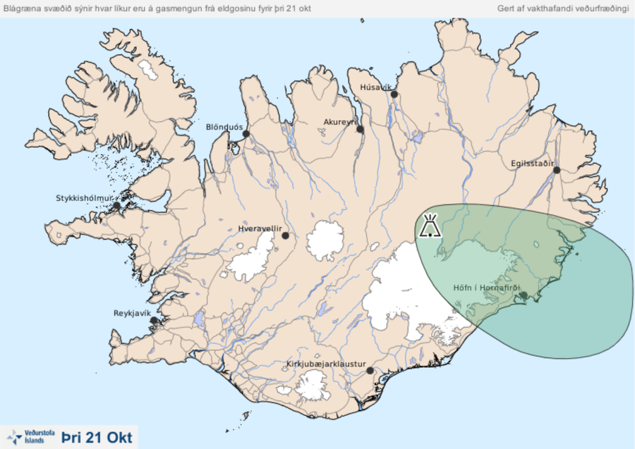
Blágræna svæðið sýnir hvar líkur eru á gasmengun frá eldgosinu fyrir mið þri 21 okt.
(The blue-green area shows the probability of gas pollution from the volcanic eruption by Mon Oct 21.)
Iceland Meteorological Office (IMO). (2014). Blágræna svæðið sýnir hvar líkur eru á gasmengun frá eldgosinu fyrir mið þri 21 okt.
Official, Map in an information statement
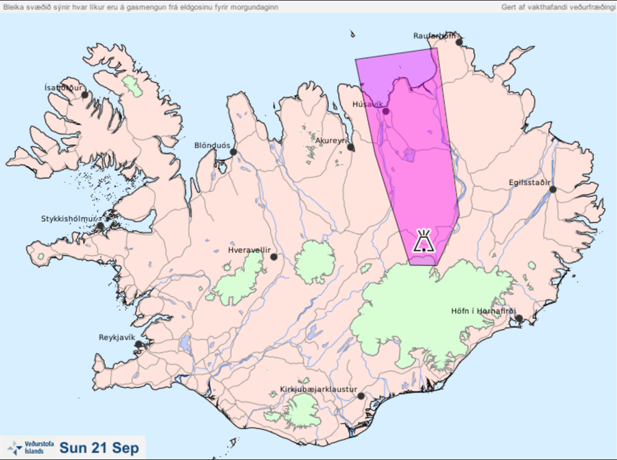
Bleika svæðið sýnir hvar líkur eru á gasmengun frá eldgosinu fyrir morgundaginn Sun 21 Sep
(The pale area shows the probability of gas pollution from the eruption before tomorrow Sun 21 Sep)
Iceland Meteorological Office (IMO). (2014). Bleika svæðið sýnir hvar líkur eru á gasmengun frá eldgosinu fyrir morgundaginn Sun 21 Sep
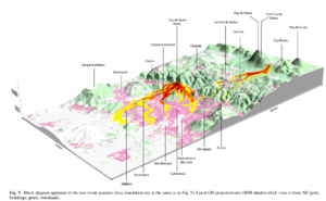
Figure in a journal article
Block diagram appraisal of the two event scenario
Figure 9 in: Latutrie, B., Andredakis, I., De Groeve, T., Harris, A. J. L., Langlois, E., de Vries, B. V. W., Saubin, E., Bilotta, G., Cappello, A., Crisci, G.M., D'ambrosio, D., Del Negro, C., Favalli, M., Fujita, E., Iovine, G., Kelfoun, K., Rongo, R., Spataro, W., Tarquini, S., Coppola, D., Ganci, G., Marchese, F., Pergola, N., & Tramutoli, V. (2016). Testing a geographical information system for damage and evacuation assessment during an effusive volcanic crisis. In: Harris, A.J.L., De Groeve, T., & Carn, S.A. (Eds.) Detecting, Modelling and Responding to Effusive Eruptions. Geological Society, London, Special Publications, 426(1), p. 649-672. https://doi.org/10.1144/SP426.19
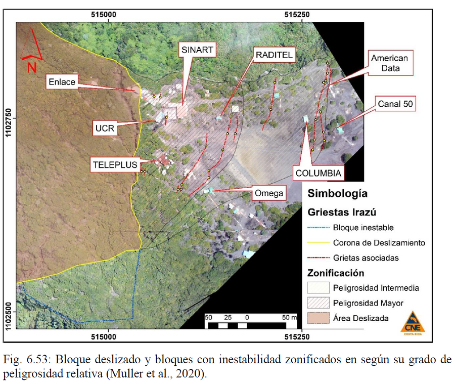
Official, Figure in hazard assessment
Bloque deslizado y bloques con inestabilidad zonificados en según su grado de peligrosidad relativa
(Sliding block and blocks with instability zoned according to their degree of relative danger)
Figure 6.53 in: Alvarado, G.E., Campos-Durán, D., Brenes-André, J., Alpízar, Y., Núñez, S., Esquivel, L., Sibaja, J.P. & Fallas, B. (2021). Peligro Volcánico del Irazú, Costa Rica. Comisión Nacional de Prevención de Riesgos y Atención de Emergencias (CNE). Deciembre 2021. (Modified from: Muller et al., 2020).