
Advanced Search for Maps
Showing 11-20 of 153
Official, Map in a booklet, long fact-sheet, or handbook
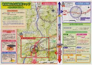
Akita-Yakeyama Volcanic Disaster Prevention Map
Akita Prefecture. (2002). Akita-Yakeyama Volcanic Disaster Prevention Map.
Official, Map in an information statement
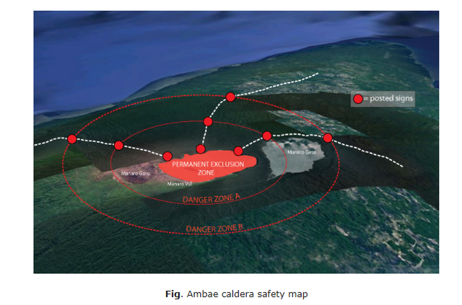
Ambae caldera safety map
Figure 1 in: Vanuatu Meteorology & Geo-Hazards Department. (2020). Vanuatu Volcano Alert Bulletin No. 4 - Ambae Activity, Thursday May 28th 2020.

Official, Sign or billboard
Area closed. Do not enter. Increased risk of eruption.
Department of Conservation. (2020). Area closed. Do not enter. Increased risk of eruption. December 2020 R183230.
Official, Flyer, brochure, short fact-sheet, or handout
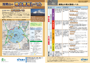
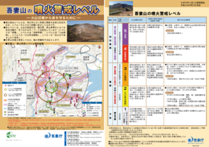
Asamayama Volcanic Alert Levels
Japan Meteorological Agency. (2016). Asamayama Volcanic Alert Levels. Volcano Monitoring and Warning Center, Volcano Division, Earthquake and Volcano Department.
Official, Flyer, brochure, short fact-sheet, or handout
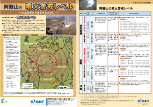
Asosan Volcanic Alert Levels
Japan Meteorological Agency. (2019). Asosan Volcanic Alert Levels. Volcano Monitoring and Warning Center, Volcano Division, Earthquake and Volcano Department.
Official, Flyer, brochure, short fact-sheet, or handout
Azumayama Volcanic Alert Levels
Japan Meteorological Agency. (2019). Azumayama Volcanic Alert Levels. Volcano Monitoring and Warning Center, Volcano Division, Earthquake and Volcano Department.
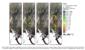
Figure in a journal article
Ballistic vulnerability or probability of casualty assuming an eruption during the time of exposure, along the Tongariro Alpine Crossing
Figure 12 in: Fitzgerald, R. H., Tsunematsu, K., Kennedy, B. M., Breard, E. C. P., Lube, G., Wilson, T. M., Jolly, A.D., Pawson, J., Rosenburg, M.D., & Cronin, S. J. (2014). The application of a calibrated 3D ballistic trajectory model to ballistic hazard assessments at Upper Te Maari, Tongariro. Journal of volcanology and geothermal research, 286, p. 248-262. https://doi.org/10.1016/j.jvolgeores.2014.04.006
Official, Flyer, brochure, short fact-sheet, or handout
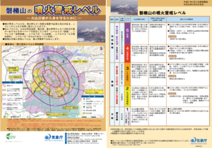
Bandaisan Volcanic Alert Levels
Japan Meteorological Agency. (2019). Bandaisan Volcanic Alert Levels. Volcano Monitoring and Warning Center, Volcano Division, Earthquake and Volcano Department.
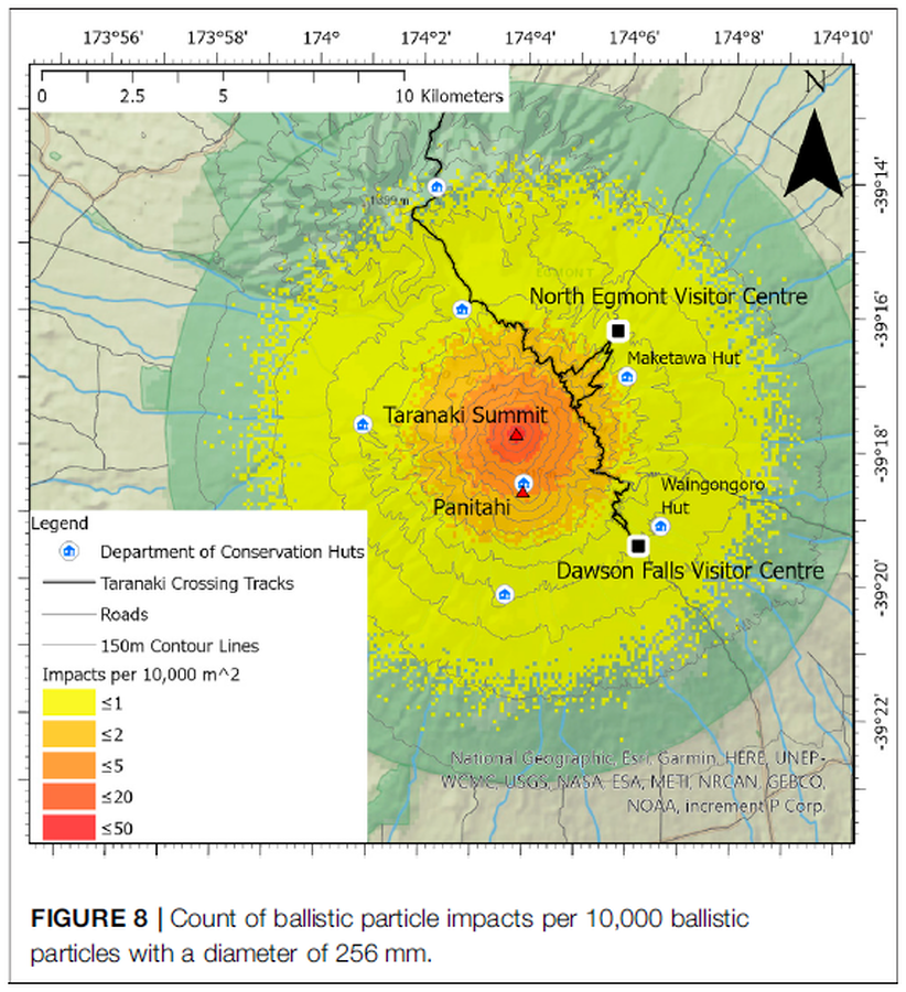
Figure in a journal article
Count of ballistic particle impacts per 10,000 ballistic particles with a diameter of 256 mm
Figure 8 in: Mead, S., Procter, J., Bebbington, M., & Rodriguez-Gomez, C. (2022). Probabilistic Volcanic Hazard Assessment for National Park Infrastructure Proximal to Taranaki Volcano (New Zealand). Frontiers in Earth Science, 435. https://doi.org/10.3389/feart.2022.832531
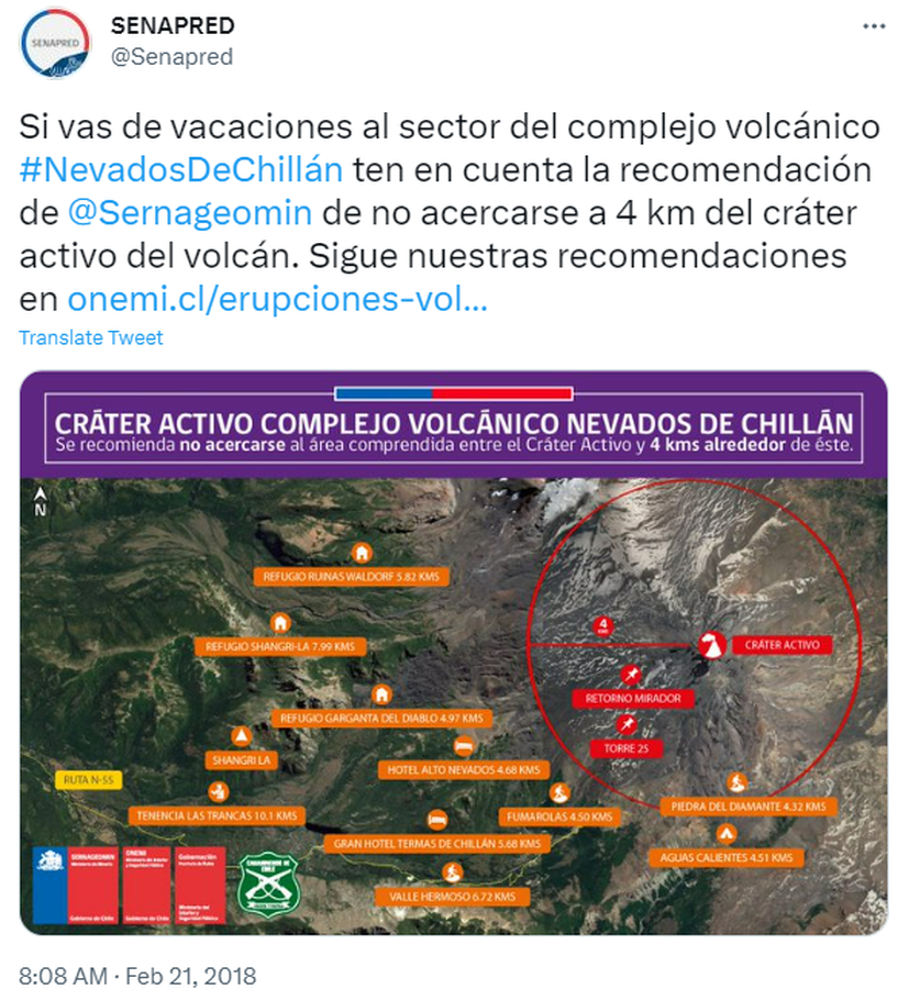
Official, Map in an information statement
Cráter Activo Complejo Volcánico Nevados de Chillán
(Nevados de Chillán Active Crater Complex )
Servicio Nacional de Geología y Minería (SERNAGEOMIN) & Oficina Nacional de Emergencia del Ministerio del Interior y Seguridad Pública (ONEMI). (2018). Cráter Activo Complejo Volcánico Nevados de Chillán. Twitter. https://twitter.com/Senapred/status/966343871520215040