
Advanced Search for Maps
Showing 61-70 of 153
Official, Map sheet or poster
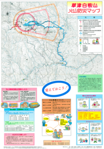
Kusatsu-Shiranesan Volcano Disaster Preventions Map
Kusatsu-Shirane Volcano Eruption Hazard Area Prediction Map Preparation Review Committee. (1995). Kusatsu-Shiranesan Volcano Disaster Preventions Map. Kusatsu Town, Marikoi Village, Naganomachi, and Rokugo Village.
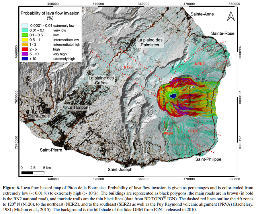
Figure in a journal article
Lava flow hazard map of Piton de la Fournaise
Figure 6 in: Chevrel, M. O., Favalli, M., Villeneuve, N., Harris, A. J., Fornaciai, A., Richter, N., Derrien, A., Di Muro, A., & Peltier, A. (2021). Lava flow hazard map of Piton de la Fournaise volcano. Natural Hazards and Earth System Sciences, 21(8), 2355-2377. https://doi.org/10.5194/nhess-21-2355-2021, 2021

Official, Sign or billboard
Map of areas not recommended not to enter or camp - Ruapehu Volcanic Risk
Department of Conservation. (2020). Map of areas not recommended not to enter or camp - Ruapehu Volcanic Risk. September 2020 R183230.
Official, Insert/poster-size map with accompanying report
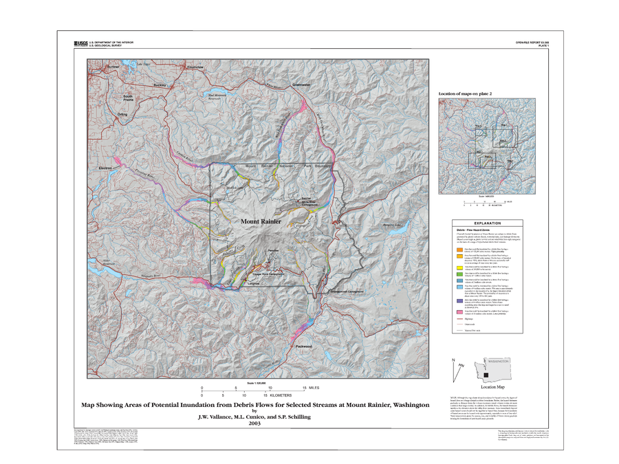
Map Showing Areas of Potential Inundation from Debris Flows for Selected Streams at Mount Rainier, Washington
Plate 1 in: Vallance, J.W., Cunico, M.L. & Schilling, S.P. (2003). Debris-flow hazards caused by hydrologic events at Mount Rainier, Washington. U.S. Geological Survey, Open-File Report 03-368, 4 p., 2 plates. https://doi.org/10.3133/ofr03368
Official, Insert/poster-size map with accompanying report
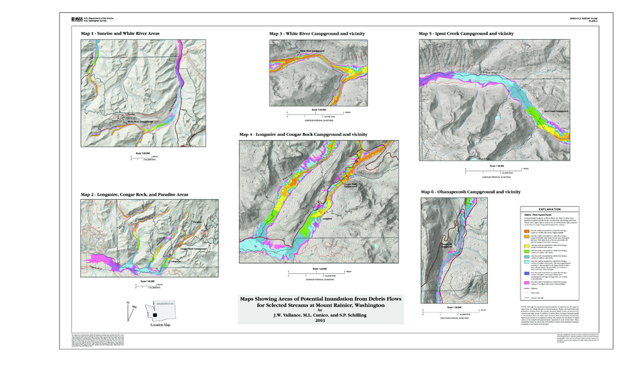
Map Showing Areas of Potential Inundation from Debris Flows for Selected Streams at Mount Rainier, Washington
Plate 2 in: Vallance, J.W., Cunico, M.L. & Schilling, S.P. (2003). Debris-flow hazards caused by hydrologic events at Mount Rainier, Washington. U.S. Geological Survey, Open-File Report 03-368, 4 p., 2 plates. https://doi.org/10.3133/ofr03368
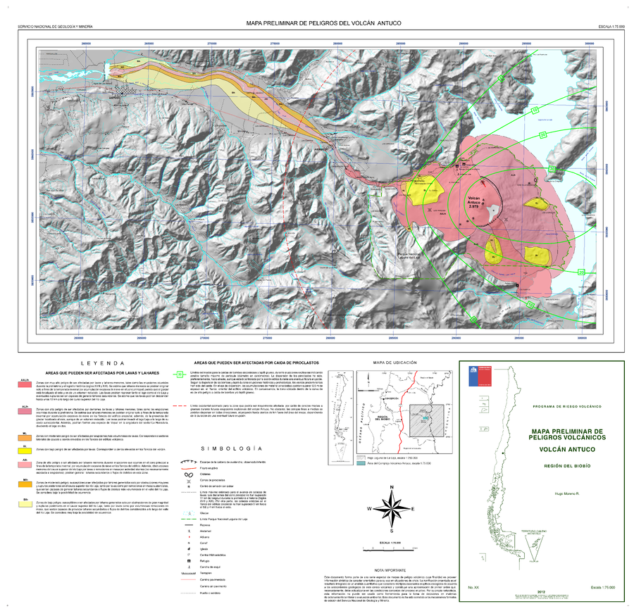
Official, Map sheet or poster
Mapa Preliminar de Peligros del Volcán Antuco
(Preliminary Hazard Map of Antuco Volcano)
Moreno, H. (2012). Mapa Preliminar de Peligros del Volcán Antuco Región del Biobio. Servicio Nacional de Geología y Minería (SERNAGEOMIN), mapa escala 1:75,000. Santiago.
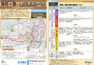
Official, Flyer, brochure, short fact-sheet, or handout
Midagahara Volcanic Alert Levels
Japan Meteorological Agency. (2019). Midagahara Volcanic Alert Levels. Volcano Monitoring and Warning Center, Volcano Division, Earthquake and Volcano Department.
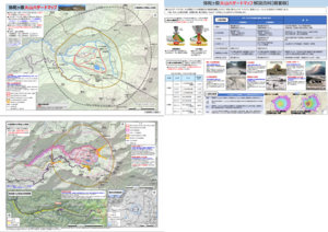
Official, Map sheet or poster
Midagahara Volcanic Hazard Map
Midagahara Volcano Disaster Prevention Council. (2018). Midagahara Volcanic Hazard Map. Toyama Prefecture Disaster Prevention Crisis and Science Division.
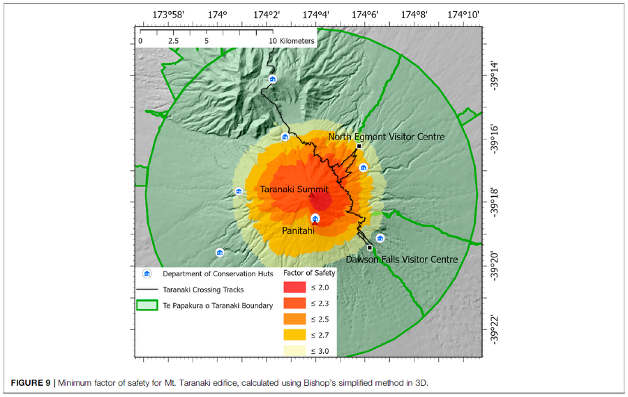
Figure in a journal article
Minimum factor of safety for Mt. Taranaki edifice
Figure 9 in: Mead, S., Procter, J., Bebbington, M., & Rodriguez-Gomez, C. (2022). Probabilistic Volcanic Hazard Assessment for National Park Infrastructure Proximal to Taranaki Volcano (New Zealand). Frontiers in Earth Science, 435. https://doi.org/10.3389/feart.2022.832531
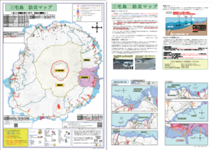
Official, Map sheet or poster
Miyakejima Disaster Prevention Map
Myake Village. (2012). Miyakejima Disaster Prevention Map.