
Advanced Search for Maps
Showing 21-30 of 63

Official, Map in a booklet, long fact-sheet, or handbook
Hazard zones for lava flows on Kilauea
Page 24 in: U.S. Geological Survey (USGS). (1997). Volcanic and Seismic Hazards on the Island of Hawaii. U.S. Geological Survey, Unumbered Series, 48 p. https://doi.org/10.3133/7000036 (Simplified from: Wright 1992)
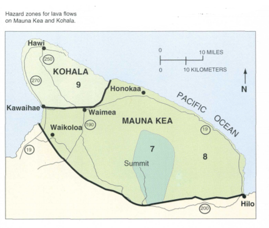
Official, Map in a booklet, long fact-sheet, or handbook
Hazard zones for lava flows on Mauna Kea and Kohala
Page 32 in: U.S. Geological Survey (USGS). (1997). Volcanic and Seismic Hazards on the Island of Hawaii. U.S. Geological Survey, Unumbered Series, 48 p. https://doi.org/10.3133/7000036 (Simplified from: Wright 1992)
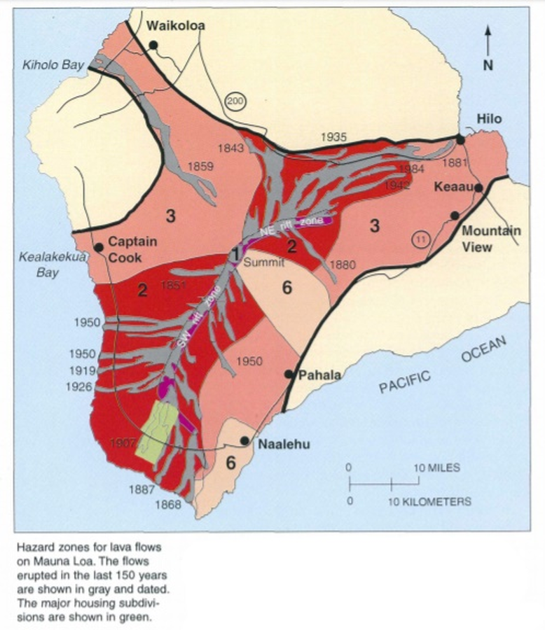
Official, Map in a booklet, long fact-sheet, or handbook
Hazard zones for lava flows on Mauna Loa
Page 28 in: U.S. Geological Survey (USGS). (1997). Volcanic and Seismic Hazards on the Island of Hawaii. U.S. Geological Survey, Unumbered Series, 48 p. https://doi.org/10.3133/7000036 (Simplified from: Wright 1992)
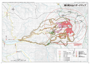
Official, Map in a booklet, long fact-sheet, or handbook
Higashikawa Town Volcano Hazard Map
Higashikawa Town Hall. (2020). Higashikawa Town Disaster Prevention Hazard Map. Hokkaido Map Co., Ltd. 30 p.
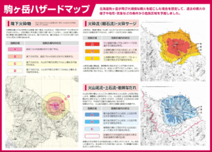
Official, Map in a booklet, long fact-sheet, or handbook
Komagatake Hazard Map
Nanae Town. Nanae Town Disaster Prevention Guide Map.
Official, Map in a booklet, long fact-sheet, or handbook
Kuttara Volcanic Disaster Prevention Map
Page 5-6 in: Noboribetsu City. (2014). Noboribetsu City Disaster Prevention Map. 47 p.
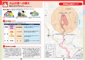
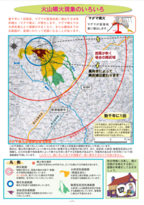
Official, Map in a booklet, long fact-sheet, or handbook
Large-scale eruption (assuming billions of cubic meters of magma eruption) pyroclastic fall
Page 13 in: Towada Volcanic Hazards Mitigation Committee. (2018). Towada Volcano Hazard Expected Impact Area Map. Omori Prefecture Disaster Risk Management Division, Akita Prefecture Disaster Prevention Division, Nagano City General Affairs Division, Kosaka Town General Affairs Division.
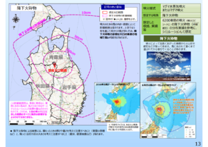
Official, Map in a booklet, long fact-sheet, or handbook
Large-scale eruption (assuming billions of cubic meters of magma eruption) pyroclastic flow/pyroclastic surge
Page 12 in: Towada Volcanic Hazards Mitigation Committee. (2018). Towada Volcano Hazard Expected Impact Area Map. Omori Prefecture Disaster Risk Management Division, Akita Prefecture Disaster Prevention Division, Nagano City General Affairs Division, Kosaka Town General Affairs Division.
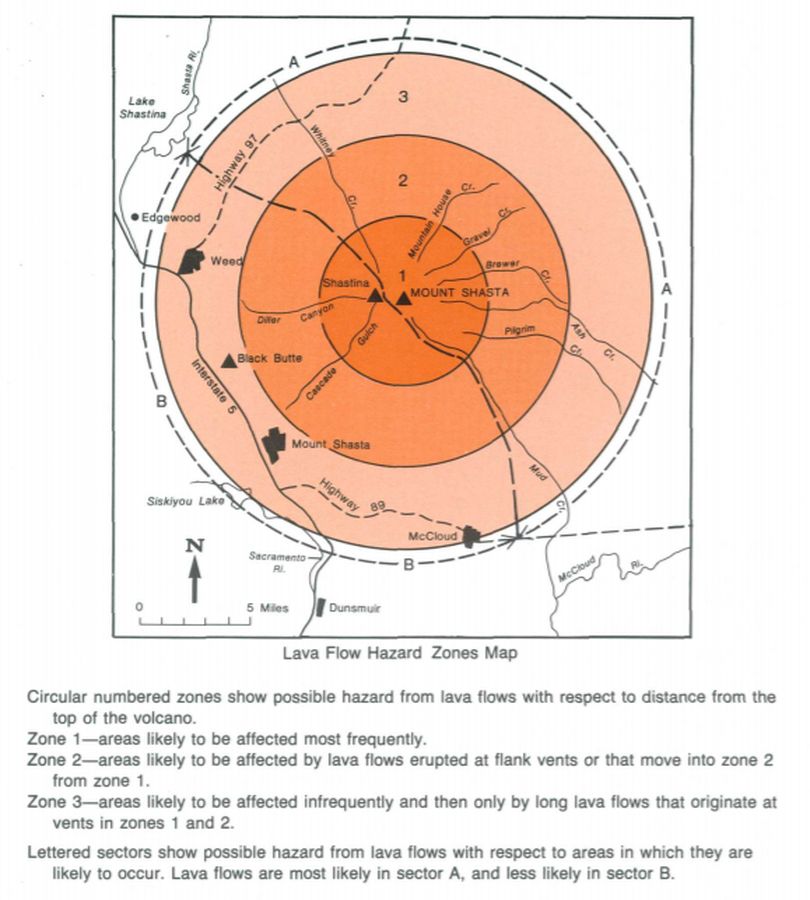
Official, Map in a booklet, long fact-sheet, or handbook
Lava Flow Hazard Zones Map
Page 17 in: Crandell, D.R. & Nichols, D.R. (1989). Volcanic hazards at Mount Shasta, California. U.S. Geological Survey, General Information Product, 22 p. https://doi.org/10.3133/70039409
Official, Map in a booklet, long fact-sheet, or handbook
Magma eruption hazard map
Page 7 in: Nasudake Volcano Disaster Prevention Council. (2014). Nasudake Volcano Disaster Prevention Handbook.