
Advanced Search for Maps
Showing 51-60 of 63
Official, Map in a booklet, long fact-sheet, or handbook
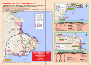
Traffic regulations and evacuation routes (When volcanic alert level 5 [5-3] (evacuation) is announced)
Page 9-10 in: Hakodate City. (2016). Disaster Prevention Handbook of Esan. 12 p.

Official, Map in a booklet, long fact-sheet, or handbook
Traffic regulations and evacuation routes (when volcanicn alert level 2 (regulation around crater) is announced)
Page 6 in: Hakodate City. (2016). Disaster Prevention Handbook of Esan. 12 p.
Official, Map in a booklet, long fact-sheet, or handbook
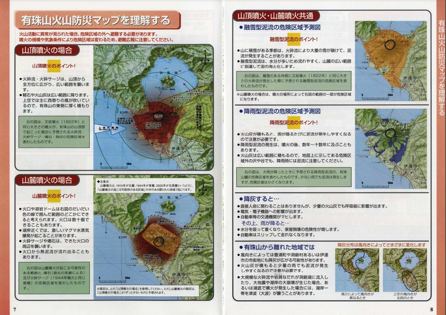
Usu Volcano Disaster Prevention Map
Hokkaido Disaster Prevention Committee. (2003). Usu Mountain Area Disaster Prevention Guidebook. Date City, Toyako Town, Sobetsu City, and Toyoura Town.
Official, Map in a booklet, long fact-sheet, or handbook
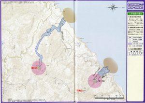
Volcanic disaster prevention map - Shiretoko-Iozan
Page 37-38 in: Shari Town. (2011). Disaster Prevention Map.
Official, Map in a booklet, long fact-sheet, or handbook
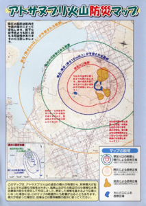
Volcanic disaster prevention map of Atosanupuri volcano
Teshikaga Town. (2001). Volcanic Disaster Prevention Map of Atosanupuri Volcano.
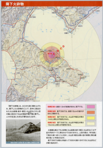
Official, Map in a booklet, long fact-sheet, or handbook
Volcanic eruption hazard area prediction map: Pyroclastic fall
Page 10 in: Volcano Disaster Management Councils of Mt.Komagatake. (2010). Volcanic disaster prevention handbook of Mt.Komagatake
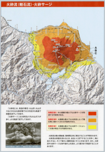
Official, Map in a booklet, long fact-sheet, or handbook
Volcanic eruption hazard area prediction map: Pyroclastic flow (pumice flow)/pyroclastic surge
Page 11 in: Volcano Disaster Management Councils of Mt. Komagatake. (2010). Volcanic disaster prevention handbook of Mt.Komagatake
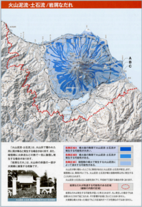
Official, Map in a booklet, long fact-sheet, or handbook
Volcanic eruption hazard area prediction map: Volcanic mudlfow, debris flow/debris avalanche
Page 12 in: Volcano Disaster Management Councils of Mt. Komagatake. (2010). Volcanic disaster prevention handbook of Mt.Komagatake

Official, Map in a booklet, long fact-sheet, or handbook
Volcanic hazard map of Meakandake - If Largest Eruption Occurs
Page 10-11 in: Volcano Disaster Management Councils of Meakandake. (2012). Meakandake Volcanic Disaster Prevention Guidebook. Kushiro City.
Official, Map in a booklet, long fact-sheet, or handbook
Volcanic hazard map of Meakandake - If Small Eruption Occurs
Page 8-9 in: Volcano Disaster Management Councils of Meakandake. (2012). Meakandake Volcanic Disaster Prevention Guidebook. Kushiro City.