
Advanced Search for Maps
Showing 21-30 of 77
Official, Figure on website
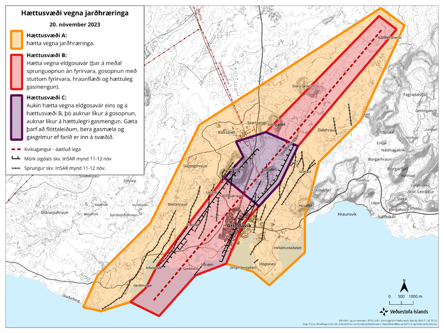
Hættusvæði vegna jarðhræringa, 20. nóvember 2023
(Earthquake hazard zone, November 20, 2023)
Icelandic Meteorological Office (IMO). (2023). Hættusvæði vegna jarðhræringa, 20. nóvember 2023.
Official, Figure on website
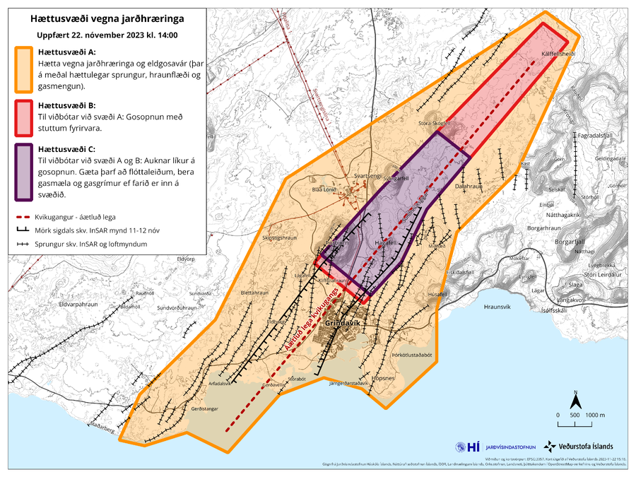
Hættusvæði vegna jarðhræringa, Uppfært 22. nóvember 2023 kl. 14:00
(Danger zone due to earthquakes, Updated November 22, 2023 at 14:00)
Icelandic Meteorological Office (IMO). (2023). Hættusvæði vegna jarðhræringa, 20. nóvember 2023.
Official, Figure on website
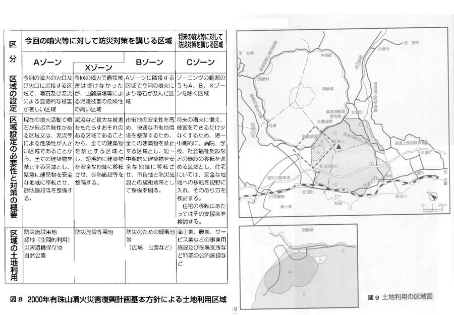
Land use area map. Land use areas according to the basic policy of the 2000 Mt. Usu eruption disaster recovery plan.
Figure 8-9 in: Nakao, M. (2005). Eruption of Mt Usu, March 31 st 2000, at Mt Usu in Hokkaido. In: Failure Knowledge Database, 100 Selected Cases. http://www.shippai.org/fkd/en/cfen/CA1000619.html. Reprinted from: The Hokkaido Shimbun Press. (2002) 2000-Nen Usu-Zan Funka (The 2000 Mt. Usu Eruption). The Hokkaido Shimbun Press.

Official, Figure on website
Map showing caldera features and caldera-related hazards at Medicine Lake volcano
U.S. Geological Survey (USGS). (2008). Map showing caldera features and caldera-related hazards at Medicine Lake volcano. U.S. Geological Survey. Medicine Lake Hazards. https://www.usgs.gov/volcanoes/medicine-lake/hazards (Modified from: Scientitic Investigations Report 2007-5174-A)
Official, Figure on website
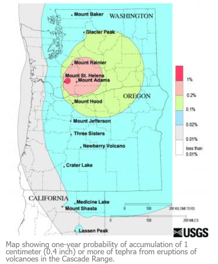
Map showing one-year probability of accumulation of 1 centimeter (0.4 inch) or more of tephra from eruptions of volcanoes in the Cascade Range.
Nathensen, M. (2013). Map showing one-year probability of accumulation of 1 centimeter (0.4 inch) or more of tephra from eruptions of volcanoes in the Cascade Range. U.S. Geological Survey. Mount Bachelor Hazards. https://www.usgs.gov/volcanoes/mount-bachelor/hazards
Official, Figure on website
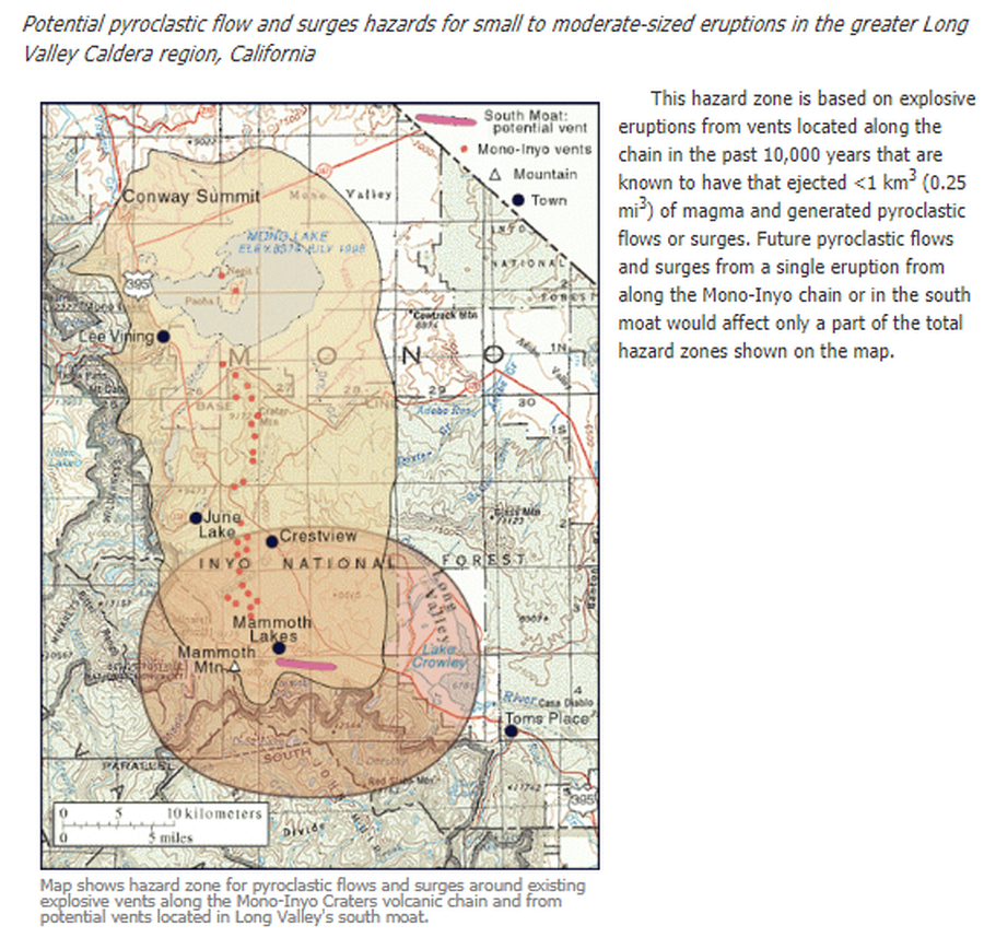
Map shows hazard zone for pyroclastic flows and surges around existing explosive vents along the Mono-Inyo Craters volcanic chain and from potential vents located in Long Valley's south moat
U.S. Geological Survey (USGS). (2012). Map shows hazard zone for pyroclastic flows and surges around existing explosive vents along the Mono-Inyo Craters volcanic chain and from potential vents located in Long Valley's south moat. U.S. Geological Survey. Long Valley Caldera Hazards, Pyroclastic Flow and Surge Hazard Zones from Potential Vents in Long Valley Caldera, California. https://www.usgs.gov/volcanoes/long-valley-caldera/pyroclastic-flow-and-surge-hazard-zones-potential-vents-long-valley
Official, Figure on website
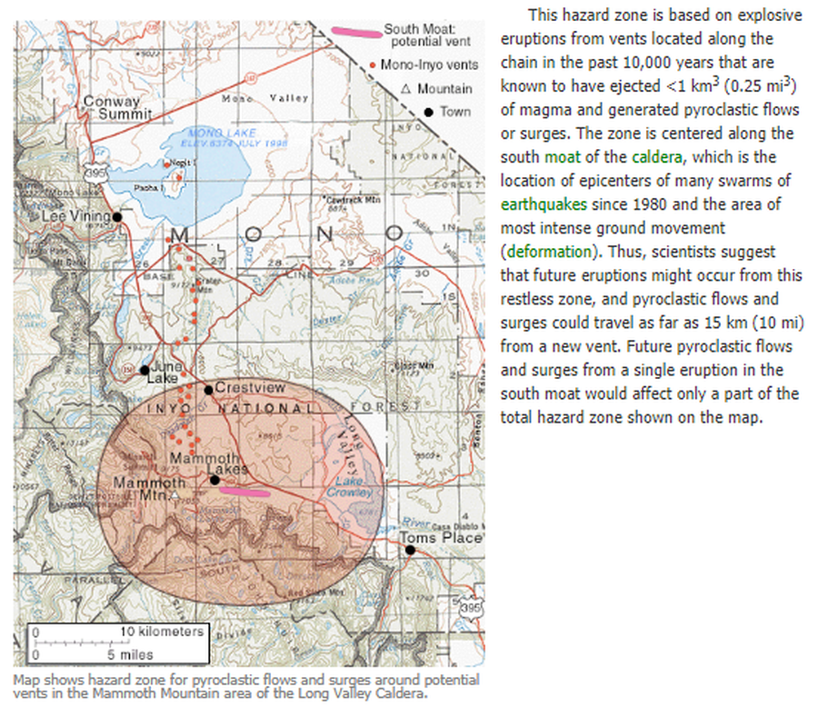
Map shows hazard zone for pyroclastic flows and surges around potential vents in the Mammoth Mountain area of the Long Valley Caldera
U.S. Geological Survey (USGS). (2012). Map shows hazard zone for pyroclastic flows and surges around potential vents in the Mammoth Mountain area of the Long Valley Caldera. U.S. Geological Survey. Long Valley Caldera Hazards, Pyroclastic Flow and Surge Hazard Zones from Potential Vents in Long Valley Caldera, California. https://www.usgs.gov/volcanoes/long-valley-caldera/pyroclastic-flow-and-surge-hazard-zones-potential-vents-long-valley
Official, Figure on website
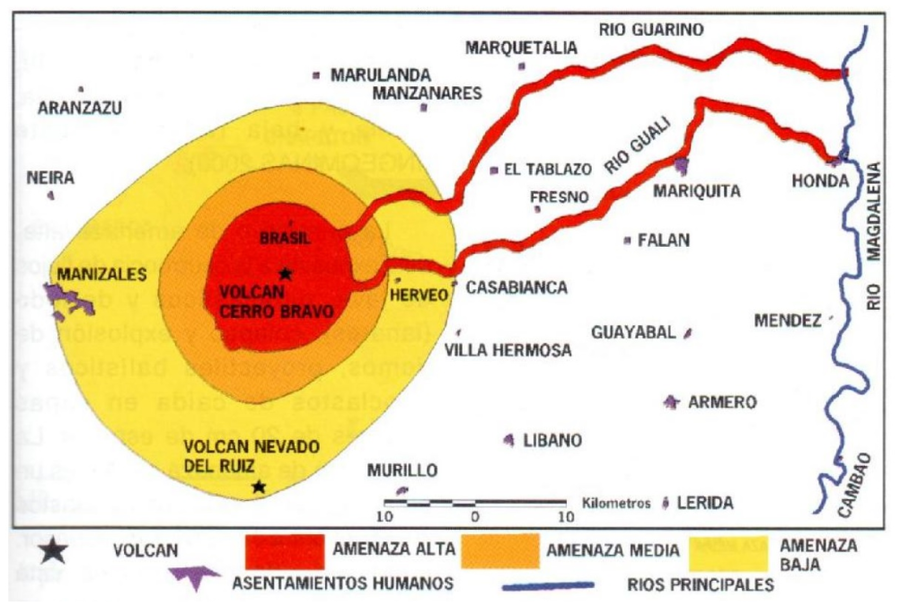
Mapa de Amenaza Potencial Volcán Cerro Bravo
(Cerro Bravo Volcano Potential Hazard Map)
Servicio Geológico Colombiano (SGC). (Year Unknown). Mapa de amenaza potencial volcán Cerro Bravo. Volcán Cerro Bravo, Mapa de Amenaza. https://www2.sgc.gov.co/sgc/volcanes/VolcanCerroBravo/Paginas/mapa-de-amanaza.aspx
Official, Figure on website
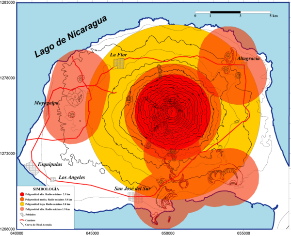
Mapa de Balísticos
(Map of Ballistics)
Navarro Collado, M. & Delgado Granados, H. (2002). Mapa de Balísticos. Instituto Nicaragüense de Estudios Territoriales (INETER) & Universidad Nacional Autónoma de México (UNAM). Mapas de Amenaza - Volcán Concepción. https://webserver2.ineter.gob.ni/geofisica/vol/concepcion/mapas_amenaza.html
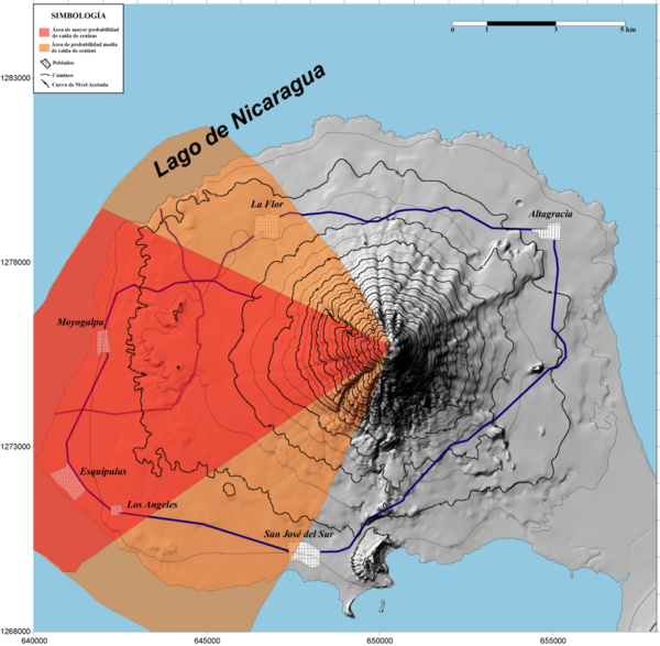
Official, Figure on website
Mapa de Caída de Cenizas
(Map of Ashfall)
Navarro Collado, M. & Delgado Granados, H. (2002). Mapa de Caída de Cenizas. Instituto Nicaragüense de Estudios Territoriales (INETER) & Universidad Nacional Autónoma de México (UNAM). Mapas de Amenaza - Volcán Concepción. https://webserver2.ineter.gob.ni/geofisica/vol/concepcion/mapas_amenaza.html