
Advanced Search for Maps
Showing 41-50 of 77
Soufrière St. Vincent, Saint Vincent and the Grenadines
Official, Figure on website
Overland Community Multi-Hazard Map
The University of the West Indies Seismic Research Centre (UWI-SRC) and National Emergency Management Organization (NEMO). (2021). Overland Community Multi-Hazard Map. https://uwiseismic.com/wp-content/uploads/2021/10/Overland-Hazard-Map-scaled.jpg
Soufrière St. Vincent, Saint Vincent and the Grenadines
Official, Figure on website
Owia/Point Community Multi-Hazard Map
The University of the West Indies Seismic Research Centre (UWI-SRC) and National Emergency Management Organization (NEMO). (2021). Owia/Point Community Multi-Hazard Map. https://uwiseismic.com/wp-content/uploads/2021/10/Owia-Point-Hazard-Map-scaled.jpg
Official, Figure on website
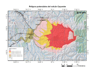
Peligros potenciales del volcán Cayambe
(Potential hazards of Cayambe volcano)
Instituto Geofísico de la Escuela Politecnica Nacional (IG-EPN). (2022). Peligros potenciales del volcán Cayambe. Complejo Volcánico Cayambe. https://www.igepn.edu.ec/amenaza-volcanica/mapa-amenaza-cayambe

Official, Figure on website
Peligros potenciales del volcán Cotopaxi
(Potential hazards of Cotopaxi volcano)
Instituto Geofísico de la Escuela Politecnica Nacional (IG-EPN). (2022). Peligros potenciales del volcán Cotopaxi. Volcán Cotopaxi. https://www.igepn.edu.ec/amenaza-volcanica/mapa-amenaza-cotopaxi
Official, Figure on website
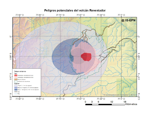
Peligros potenciales del volcán Reventador
(Potential hazards of Reventador volcano)
Instituto Geofísico de la Escuela Politecnica Nacional (IG-EPN). (2022). Peligros potenciales del volcán Reventador. Volcán El Reventador. https://www.igepn.edu.ec/amenaza-volcanica/mapa-amenaza-reventador
Official, Figure on website
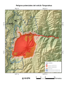
Peligros potenciales del Volcán Tungurahua
(Potential hazards of Tungurahua volcano)
Instituto Geofísico de la Escuela Politecnica Nacional (IG-EPN). (2022). Peligros potenciales del volcán Tungurahua. Volcán Tungurahua. https://www.igepn.edu.ec/amenaza-volcanica/mapa-amenaza-tungurahua
Official, Figure on website
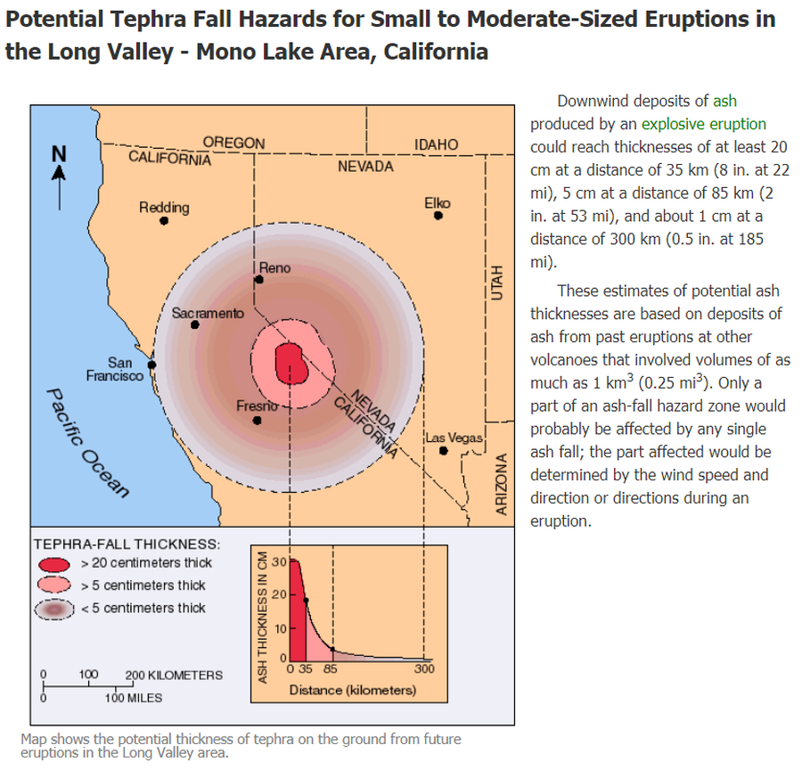
Potential Tephra Fall Hazards for Small to Moderate-Sized Eruptions in the Long Valley - Mono Lake Area, California
U.S. Geological Survey (USGS). (2012). Potential Tephra Fall Hazards for Small to Moderate-Sized Eruptions in the Long Valley - Mono Lake Area, California. U.S. Geological Survey. Long Valley Caldera, Volcano Hazards in the Long Valley - Mono Lake Area, California. https://www.usgs.gov/volcanoes/long-valley-caldera/volcano-hazards-long-valley-mono-lake-area-california
Soufrière St. Vincent, Saint Vincent and the Grenadines
Official, Figure on website
Rose Hall Community Multi-Hazard Map
The University of the West Indies Seismic Research Centre (UWI-SRC) and National Emergency Management Organization (NEMO). (2021). Rose Hall Community Multi-Hazard Map. https://uwiseismic.com/wp-content/uploads/2021/10/Rose-Hall_Hazard-Map-scaled.jpg
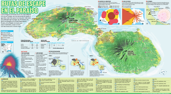
Official, Figure on website
Rutas de Escape en el Paraíso
(Escape Routes in Paraíso)
Wilder Pérez, R. & Luis González. (Year Unknown). Rutas de Escape en el Paraíso. La Prensa. https://webserver2.ineter.gob.ni/geofisica/vol/concepcion/doc/rutas-evacuacion.htm
Soufrière St. Vincent, Saint Vincent and the Grenadines
Official, Figure on website
Sandy Bay Community Multi-Hazard Map
The University of the West Indies Seismic Research Centre (UWI-SRC) and National Emergency Management Organization (NEMO). (2021). Sandy Bay Community Multi-Hazard Map. https://uwiseismic.com/wp-content/uploads/2021/10/Sandy-Bay_Hazard-Map-scaled.jpg