
Advanced Search for Maps
Showing 11-20 of 77
Soufrière St. Vincent, Saint Vincent and the Grenadines
Official, Figure on website
Georgetown Community Multi-Hazard Map
The University of the West Indies Seismic Research Centre (UWI-SRC) and National Emergency Management Organization (NEMO). (2021). Georgetown Community Multi-Hazard Map. https://uwiseismic.com/wp-content/uploads/2021/10/Georgetown-Hazard-Map-scaled.jpg
Official, Figure on website
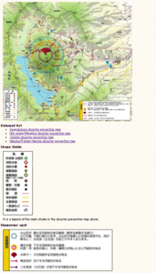
Hakone-machi volcanic disaster prevention map whole area
Hakone-machi Town. (2004). Entire volcano disaster prevention map. Hakone Volcano Disaster Prevention Map. https://www.town.hakone.kanagawa.jp/index.cfm/10,1218,46,167,html
Official, Figure on website
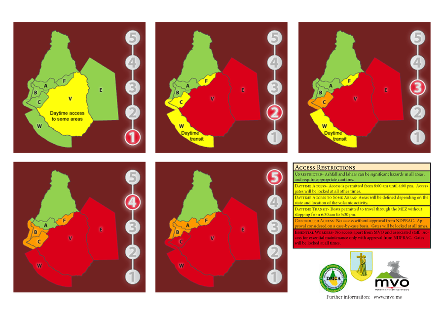
Hazard Level System
Montserrat Volcano Observatory (MVO). (Year Unknown). Hazard Level System. Soufrière Hills Volcano, Monsterrat, Hazards Level System.
Official, Figure on website
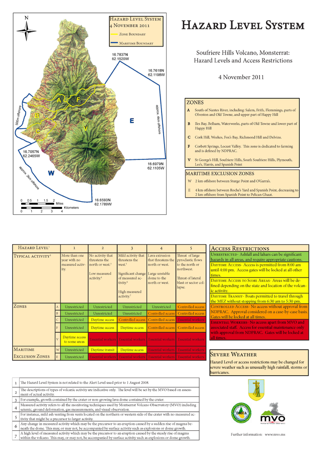
Hazard Level System Soufriere Hills Volcano, Monsterrat: Hazard Levels and Access Restrictions 4 November 2011
Montserrat Volcano Observatory (MVO). (2011) Hazard Level System. Soufriere Hills Volcano, Monsterrat: Hazard Levels and Access Restrictions 4 November 2011. http://www.mvo.ms/pub/Hazard_Level_System/HLS-20111104.pdf

Official, Figure on website
Hazard Level: 1
Montserrat Volcano Observatory (MVO). (Year Unknown). Hazard Level. Retrieved 29 March, 2022, from http://www.mvo.ms/
Official, Figure on website
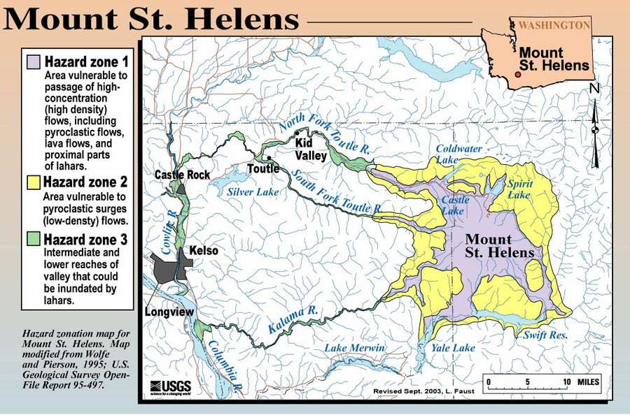
Hazard Zonation Map for Mount St. Helens
Faust, L. (2003). Hazard zonation map for Mount St. Helens. U.S. Geological Survey. (Simplified from: Wolfe & Pierson 1995) (Reprinted in: Bluth, G. (Year Unknown). Mt. St. Helens Activity Update (+ 2004 events). Michigan Technological University, GE4150 Lecture. https://pages.mtu.edu/~gbluth/Teaching/GE4150/lecture_pdfs/L11_msh_seismic.pdf#page=2)
Official (foreign agency), Figure on website
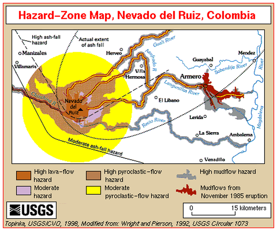
Hazard-Zone Map, Nevado del Ruiz, Colombia
Topinka, L. (1998). Hazard-Zone Map, Nevado del Ruiz, Colombia. U.S. Geological Survey. http://vulcan.wr.usgs.gov/Imgs/Gif/Ruiz/Maps/map_ruiz_hazard_zones.gif (Modified from: Wright et al. 1992)
Official, Figure on website
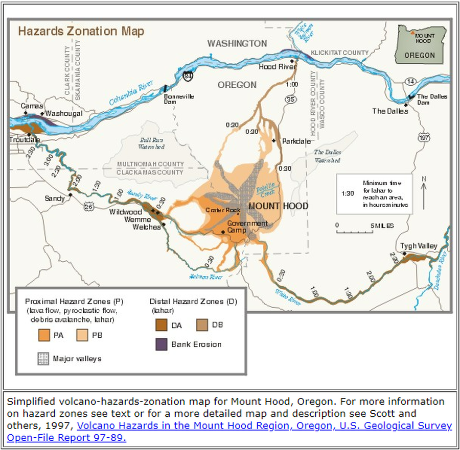
Hazards Zonation Map
Gardner, C.A., Scott, W.E., Major, J.J., & Pierson, T.C. (2000). Hazards Zonation Map. Mount Hood—History and Hazards of Oregon's Most Recently Active Volcano. U.S. Geological Survey, Fact Sheet 060-00 (Online Version 1.0). https://doi.org/10.3133/fs06000
Official, Figure on website
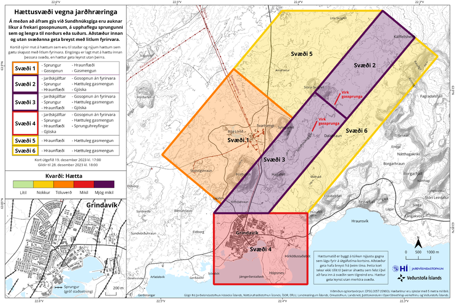
Hættusvæði vegna jarðhræringa
(Danger zone due to earthquakes)
Icelandic Meteorological Office (IMO). (2023). Hættusvæði vegna jarðhræringa, 19. desember 2023.
Official, Figure on website
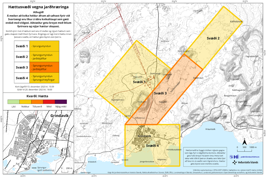
Hættusvæði vegna jarðhræringa
(Danger zone due to earthquakes)
Icelandic Meteorological Office (IMO). (2023). Hættusvæði vegna jarðhræringa, 13. desember 2023.