
Advanced Search for Maps
Showing 61-70 of 77
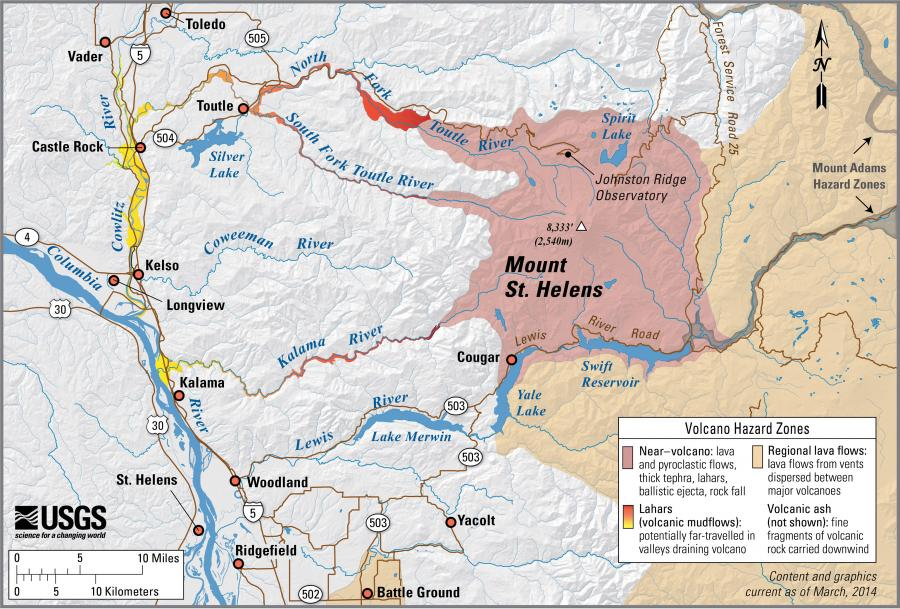
Official, Figure on website
Simplified volcano hazards map of Mount St. Helens, Washington
Wolfe, E.W., Pierson, T.C., Driedger, C.L., Scott, W.E., Iverson, R.M., Ramsey, D.W., & Faust, L.M. (2014). Simplified volcano hazards map of Mount St. Helens, Washington. U.S. Geological Survey. Mount St. Helens, Washington Simplified Hazards Map. https://www.usgs.gov/media/images/mount-st-helens-washington-simplified-hazards-map (Modified from: U.S. Geological Survey, Open-File Report 95-497)

Official, Figure on website
Simplified volcano hazards map of Newberry Volcano, Oregon
Sherrod, D.R., Mastin, L.G., Scott, W.E., Schilling, S.P., Driedger, C.L., Iverson, R.M., Ramsey, D.W., & Faust, L.M. (2014). Simplified volcano hazards map of Newberry Volcano, Oregon. U.S. Geological Survey. Newberry Volcano, OR simplified hazards map. https://www.usgs.gov/media/images/newberry-volcano-or-simplified-hazards-map (Modified from: U.S. Geological Survey, Open-File Report 97-513)
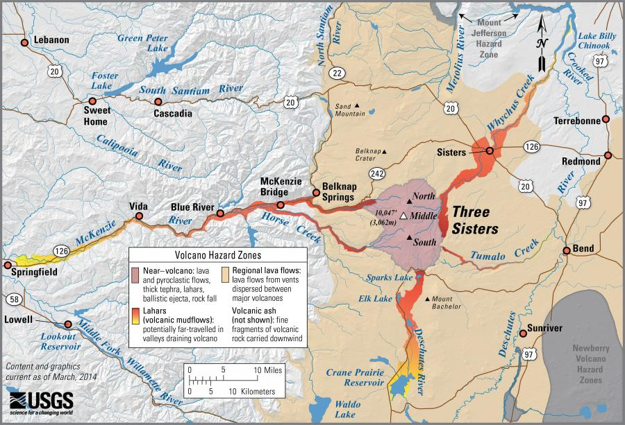
Official, Figure on website
Simplified volcano hazards map of Three Sisters, Oregon
Scott, W.E., Iverson, R.M., Schilling, S.P., Fisher, B.J., Driedger, C.L., Ramsey, D.W., & Faust, L.M. (2014). Simplified volcano hazards map of Three Sisters, Oregon. U.S. Geological Survey. Three Sisters, OR Simplified Hazards Map. https://www.usgs.gov/media/images/three-sisters-or-simplified-hazards-map (Modified from: U.S. Geological Survey, Open-File Report 99-437)
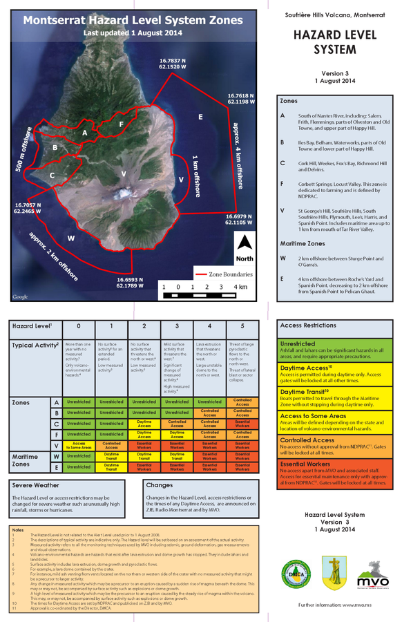
Official, Figure on website
Soufriere Hills Volcano, Monsterrat. Hazards Level System. Version 3, 1 August 2014
Montserrat Volcano Observatory (MVO). (2014). Soufrière Hills Volcano, Monsterrat. Hazard Level System. Version 3, 1 August 2014. http://www.mvo.ms/pub/Hazard_Level_System/HLS-20140801.pdf
Soufrière St. Vincent, Saint Vincent and the Grenadines
Official, Figure on website
Spring Village Community Multi-Hazard Map
The University of the West Indies Seismic Research Centre (UWI-SRC) and National Emergency Management Organization (NEMO). (2021). Spring Village Community Multi-Hazard Map. https://uwiseismic.com/wp-content/uploads/2021/10/Spring-Village-Hazard-Map-scaled.jpg
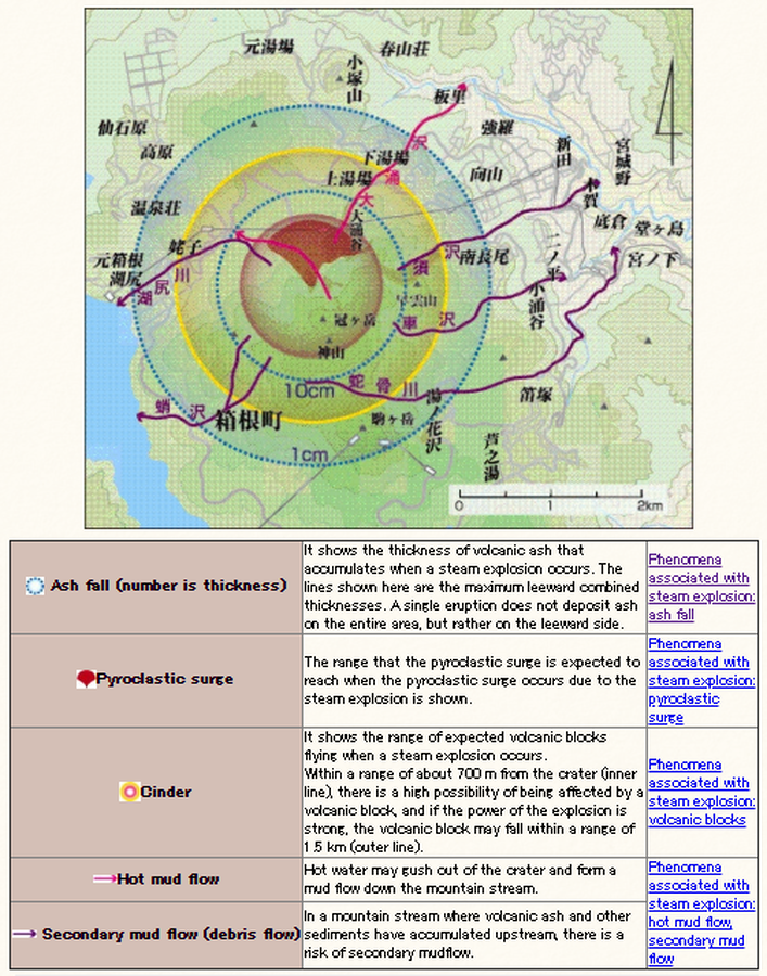
Official, Figure on website
Steam explosion
Hakone-machi Town. (2004). When volcanic activity increases. Hakone Volcano Disaster Prevention Map. https://www.town.hakone.kanagawa.jp/index.cfm/10,1214,46,167,html

Official, Figure on website
Tephra fall probabilities based on 10 historical Grímsvötn eruptions
Guðmundsson, M.T. & Larsen, G. (2019). Grímsvötn. In: Oladottir, B., Larsen, G. & Guðmundsson, M. T. Catalogue of Icelandic Volcanoes. Iceland Meteorological Office (IMO), Univeristy of Iceland, and Civil Protection Department of the National Commissioner of the Iceland Police (CPD-NCIP). https://icelandicvolcanos.is//index.html (Simplified from: Thorarinsson 1974, Gudmundsson et al. 2004, Oddsson et al. 2012, Gudmundsson et al. 2013)
Official, Figure on website
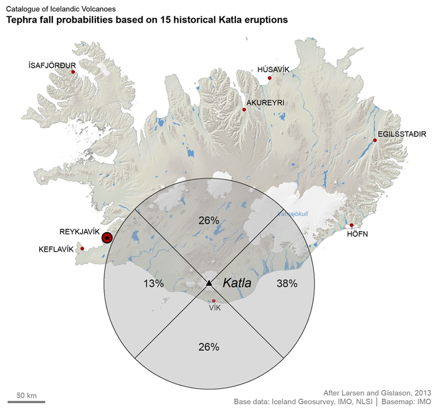
Tephra fall probabilities based on 15 historical Katla eruptions
Larsen, G. & Guðmundsson, M.T. (2019). Katla. In: Oladottir, B., Larsen, G. & Guðmundsson, M. T. Catalogue of Icelandic Volcanoes. Iceland Meteorological Office (IMO), Univeristy of Iceland, and Civil Protection Department of the National Commissioner of the Iceland Police (CPD-NCIP). https://icelandicvolcanos.is//index.html (Simplified from: Larsen & Gíslason 2013)
Official, Figure on website
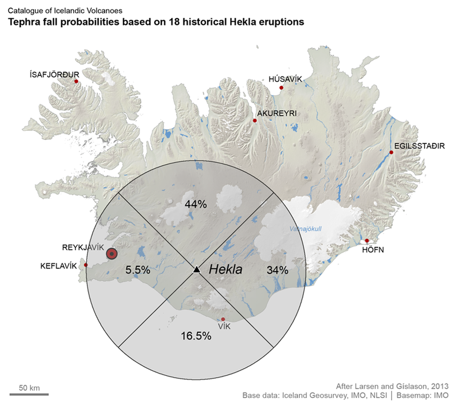
Tephra fall probabilities based on 18 historical Hekla eruptions
Larsen, G. & Thordarson, T. (2019). Hekla. In: Oladottir, B., Larsen, G. & Guðmundsson, M. T. Catalogue of Icelandic Volcanoes. Iceland Meteorological Office (IMO), Univeristy of Iceland, and Civil Protection Department of the National Commissioner of the Iceland Police (CPD-NCIP). https://icelandicvolcanos.is//index.html (Simplified from: Larsen & Gíslason 2013)
Official, Figure on website
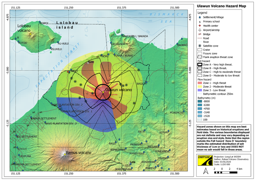
Ulawun Volcano Hazard Map
Rabaul Volcano Observatory (RVO). (2020). Ulawun Volcanic Hazard Map. Department of Mineral Policy and Geohazards Management (DMPGM).