
Advanced Search for Maps
Showing 21-30 of 354

Official, Map sheet or poster
Bulusan Volcano Pyroclastic Flow Hazard Map
Philippine Institute of Volcanology and Seismology (PHIVOLCS). (2000). Bulusan Volcano Pyroclastic Flow Hazard Map.
Official, Map sheet or poster
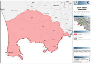
Campi Flegrei "Zona Rossa"
(Campi Flegrei "Red Zone")
Dipartimento della Protezione Civile. (2014). Campi Flegrei "Zona Rossa" - Aggiornamento Pianificazione Nazionale di Emergenza per Rischio Vulcanico.
Official, Map sheet or poster
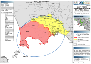
Campi Flegrei Mappa di Delimitazione della "Zona Gialla"
(Campi Flegrei Delimitation Map of the "Yellow Zone")
Dipartimento della Protezione Civile. (2015). Campi Flegrei Mappa di Delimitazione della "Zona Gialla" - Aggiornamento Pianificazione Nazionale di Emergenza per Rischio Vulcanico.
Official, Map sheet or poster
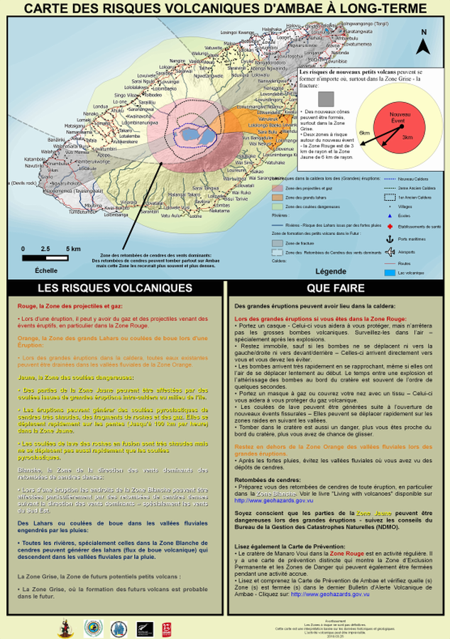
Carte des Risques Volcaniques d'Ambae à Long-terme
(Ambae Long-Term Background Volcanic Hazards Map)
Vanuatu Meteorology & Geo-Hazards Department. (2019). Carte des Risques Volcaniques d'Ambae à Long-terme. Government of Vanuatu, Vanuatu Meteorology & Geo-Hazards Department, Vanuatu National Disaster Risk Management Office, New Zealand Foreign Affairs & Trade Aid Programme, GNS Science.
Official, Map sheet or poster
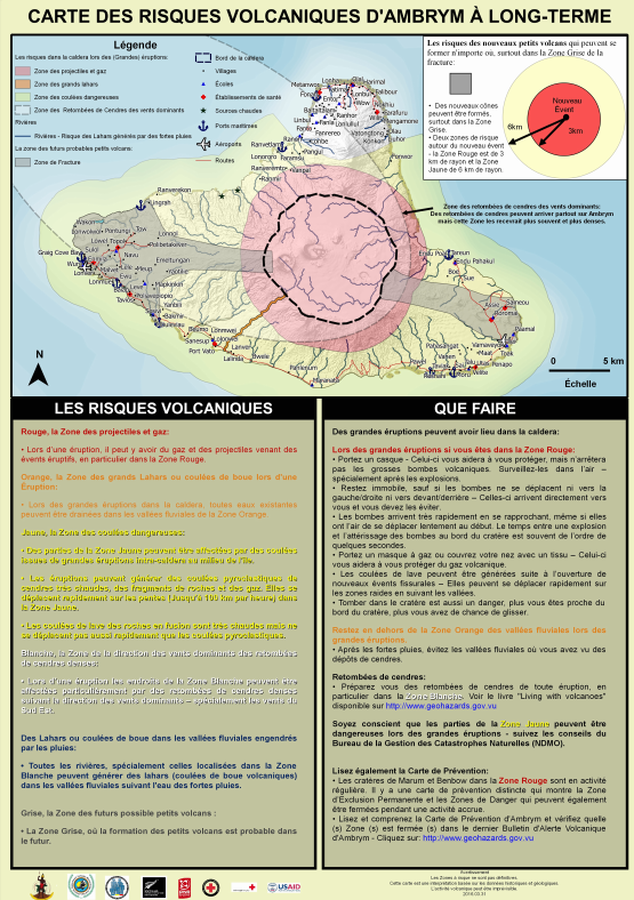
Carte des Risques Volcaniques d'Ambrym à Long-terme
(Ambrym Long-Term Background Volcanic Hazards Map)
Vanuatu Meteorology & Geo-Hazards Department. (2016). Carte des Risques Volcaniques d'Ambrym à Long-terme. Government of Vanuatu, Vanuatu Meteorology & Geo-Hazards Department, Vanuatu National Disaster Risk Management Office, New Zealand Foreign Affairs & Trade Aid Programme, GNS Science, The Vanuatu Red Cross Society, Croix Rouge Francaise, USAID.
Official, Map sheet or poster
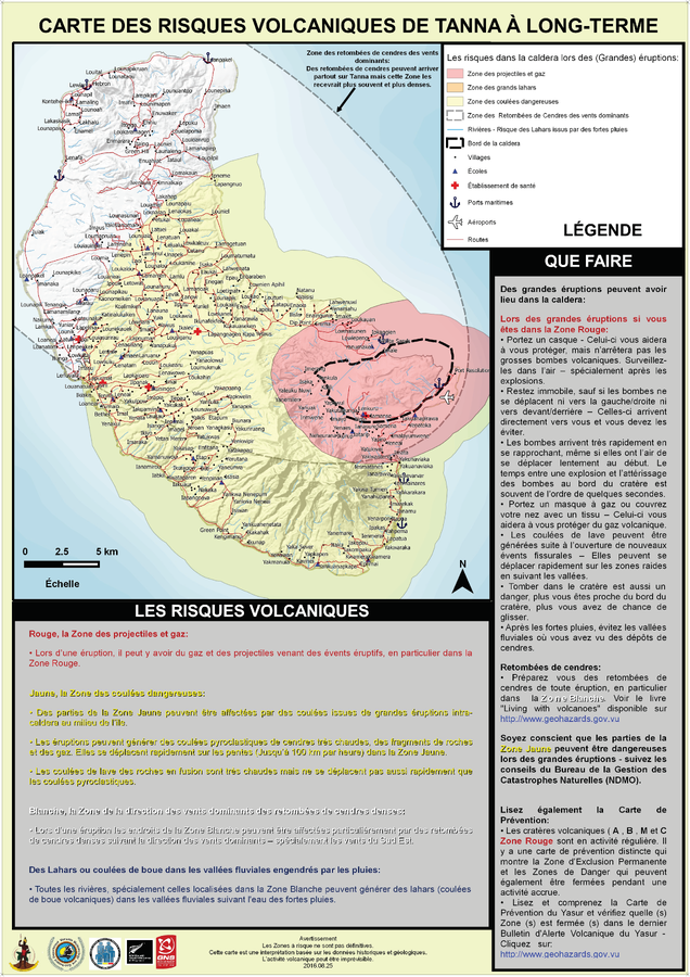
Carte des Risques Volcaniques de Tanna à Long-Terme
(Tanna Long-Term Background Volcanic Hazards Map)
Vanuatu Meteorology & Geo-Hazards Department. (2016). Carte des Risques Volcaniques de Tanna à Long-Terme. Government of Vanuatu, Vanuatu Meteorology & Geo-Hazards Department, Vanuatu National Disaster Risk Management Office, New Zealand Foreign Affairs & Trade Aid Programme, GNS Science.
Official, Map sheet or poster
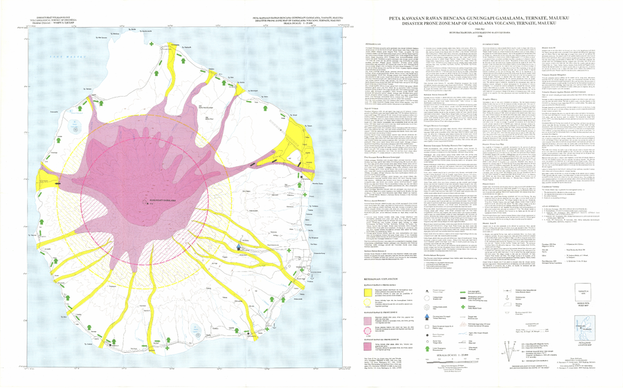
Disaster Prone Zone Map of Gamalama Volcano, Ternate, Maluku
Bacharudin, R., Martono, A., & Djuhara, A. (1996). Disaster Prone Zone Map of Gamalama Volcano, Ternate, Maluku. Volcanological Survey of Indonesia (VSI).
Official, Map sheet or poster
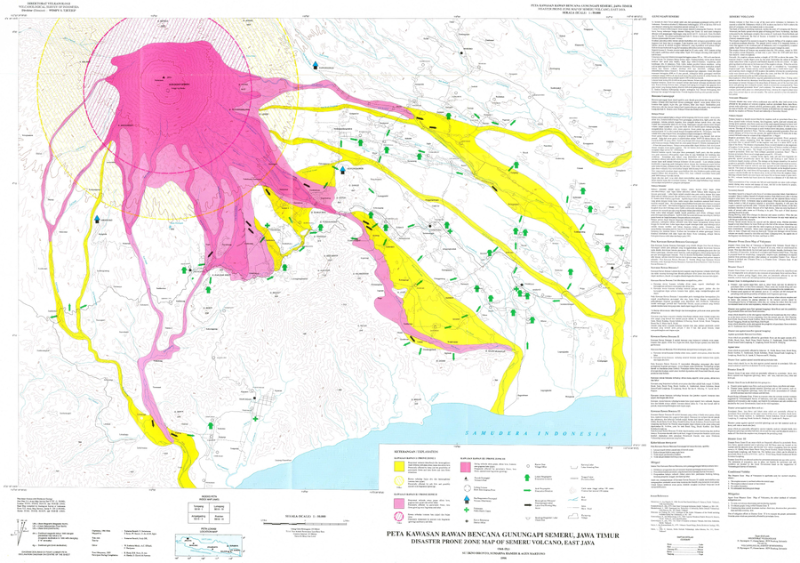
Disaster Prone Zone Map of Semeru Volcano, East Java
Bronto, S., Hamidi, S., & Martono, A. (1996). Disaster Prone Zone Map of Semeru Volcano, East Java. Volcanological Survey of Indonesia (VSI).
Official, Map sheet or poster
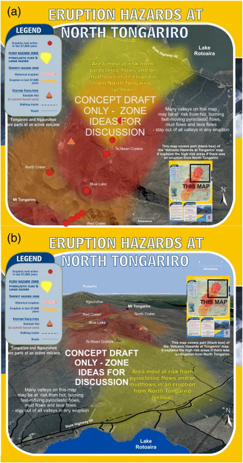
Eruption Hazards at North Tongariro
GNS Science (compiler). (2012). Te Maari Eruption Phenomena. Version 0.1, 6 August 2012. (Reprinted in: Leonard, G. S., Stewart, C., Wilson, T. M., Procter, J. N., Scott, B. J., Keys, H. J., Jolly, G.E., Wardman, J.B., Cronin. S.J. & McBride, S. K. (2014). Integrating multidisciplinary science, modelling and impact data into evolving, syn-event volcanic hazard mapping and communication: a case study from the 2012 Tongariro eruption crisis, New Zealand. Journal of Volcanology and Geothermal Research, 286, p. 208-232. https://doi.org/10.1016/j.jvolgeores.2014.08.018)
Official, Map sheet or poster
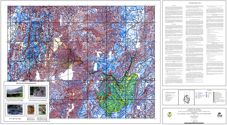
Evaluación de la Amenaza Potencial del Volcán Cerro Machín
(Assessment of Potential Hazards of Cerro Machín Volcano)
Méndez, R.A., Cortés, G.P., & Cepeda, H. (2002). Evaluación de la Amenaza Potencial del Volcán Cerro Machín. Instituto de Investigación e Información Geocientífica, Minero - Ambiental y Nuclear (INGEOMINAS). mapa escala 1:150,213. Bogotá with accompanying text: INGEOMINAS (Instituto de Investigación e Información Geocientífica, Minero, Ambiental Y Nuclear). (2003) Memoria explicativa del Mapa de Amenaza Volcánica del Cerro Machín. Bogotá.